Butun axtardiqlarinizi tapmaq ucun buraya: DAXIL OLUN
  Mp4 Mp3 Axtar Yukle
  Video Axtar Yukle
  Shekil Axtar Yukle
  Informasiya Melumat Axtar
  Hazir Inshalar Toplusu
  AZERI CHAT + Tanishliq
  1-11 Sinif Derslikler Yukle
  Saglamliq Tibbi Melumat
  Whatsapp Plus Yukle(Yeni)

  • Ana səhifə
  • Təsadüfi
  • Yaxınlıqdakılar
  • Daxil ol
  • Nizamlamalar
İndi ianə et Əgər Vikipediya sizin üçün faydalıdırsa, bu gün ianə edin.

Fayl:Map of territorial growth 1775.jpg

  • Fayl
  • Müzakirə
  • Lokal izah əlavə et
  • Fayl
  • Faylın tarixçəsi
  • Faylın istifadəsi
  • Faylın qlobal istifadəsi
  • Metaməlumatlar
Fayl:Map of territorial growth 1775.jpg
Sınaq göstərişi ölçüsü: 456 × 600 piksel. Digər ölçülər: 182 × 240 piksel | 570 × 750 piksel.

Faylın orijinalı (570 × 750 piksel, fayl həcmi: 172 KB, MIME növü: image/jpeg)

Bu fayl Vikianbarda yerləşir. Açıqlama səhifəsindəki məlumatlar aşağıda göstərilib.
Vikianbar azad lisenziyalı media anbarıdır. Siz də töhfə verə bilərsiniz.
File:Map of territorial growth 1775.svg is a vector version of this file. It should be used in place of this JPG file when not inferior.

File:Map of territorial growth 1775.jpg → File:Map of territorial growth 1775.svg

For more information, see Help:SVG.

In other languages
Alemannisch ∙ العربية ∙ беларуская (тарашкевіца) ∙ български ∙ বাংলা ∙ català ∙ нохчийн ∙ čeština ∙ dansk ∙ Deutsch ∙ Ελληνικά ∙ English ∙ British English ∙ Esperanto ∙ español ∙ eesti ∙ euskara ∙ فارسی ∙ suomi ∙ français ∙ Frysk ∙ galego ∙ Alemannisch ∙ עברית ∙ हिन्दी ∙ hrvatski ∙ magyar ∙ հայերեն ∙ Bahasa Indonesia ∙ Ido ∙ italiano ∙ 日本語 ∙ ქართული ∙ 한국어 ∙ lietuvių ∙ македонски ∙ മലയാളം ∙ Bahasa Melayu ∙ norsk bokmål ∙ Plattdüütsch ∙ Nederlands ∙ norsk nynorsk ∙ norsk ∙ occitan ∙ polski ∙ prūsiskan ∙ português ∙ português do Brasil ∙ română ∙ русский ∙ sicilianu ∙ Scots ∙ slovenčina ∙ slovenščina ∙ српски / srpski ∙ svenska ∙ தமிழ் ∙ ไทย ∙ Türkçe ∙ татарча / tatarça ∙ українська ∙ vèneto ∙ Tiếng Việt ∙ 中文 ∙ 中文(中国大陆) ∙ 中文(简体) ∙ 中文(繁體) ∙ 中文(马来西亚) ∙ 中文(新加坡) ∙ 中文(臺灣) ∙ +/−
New SVG image


Xülasə

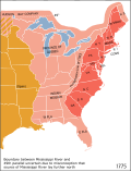
İzahMap of territorial growth 1775.jpg
Deutsch: Östliches Nordamerika im Jahre 1775 mit der vom Königreich Großbritannien kontrollierten Provinz Quebec und den dreizehn Kolonien an der Küste sowie dem von diesen durch die Proklamationslinie von 1763 abgeschiedene Indian Reserve (siehe auch: Britische Kolonisierung Amerikas).
English: Eastern North America in 1775: The map shows part of the British Province of Quebec, the British thirteen colonies on the Atlantic coast, the interior Indian Reserve, and parts of New Spain. Some colonies claimed land further west, but only the areas shown in red were legally open to settlement by European-Americans, due to the Royal Proclamation of 1763). East Florida and West Florida had been acquired by Britain from Spain, and did not join the American Revolution the next year.
Italiano: Nel 1775, l'Inghilterra aveva il dominio sulle zone indicate in rosso e rosa sulla mappa e la Spagna su quelle arancione. La zona rossa è quella relativa alle 13 colonie aperte agli insediamenti dopo la proclamazione del 1763.
Tarix 1775
Mənbə National Atlas of the United States via en.wikipedia
Müəllif see below
İcazə
(Faylın təkrar istifadəsi)
Public domainPublic domainfalsefalse
Public domain
This map was obtained from an edition of the National Atlas of the United States. Like almost all works of the U.S. federal government, works from the National Atlas are in the public domain in the United States.
Online access: NationalAtlas.gov | 1970 print edition: Library of Congress, Perry-Castañeda Library

čeština | Deutsch | English | français | Bahasa Indonesia | italiano | македонски | മലയാളം | sicilianu | 中文 | 中文(简体)‎ | 中文(繁體)‎ | +/−

Digər versiyalar

[]

  • català
    català
  • English
    English
  • English (JPG)
    English (JPG)
  • English (similar version)
    English (similar version)
  • español
    español

Başlıqlar

Bu faylın nəyi təmsil etdiyinə dair bir sətirlik izahat əlavə et

Bu faylda təsvir olunan elementlər

təsvir edir

copyright status ingilis

ictimai mülkiyyət

yurisdiksiyasındadır: Amerika Birləşmiş Ştatları
təyinetmə üsulu: work of the federal government of the United States ingilis

yaranma tarixi

1775

Faylın tarixçəsi

Faylın əvvəlki versiyasını görmək üçün gün/tarix bölməsindəki tarixlərə klikləyin.

Tarix/VaxtMiniatürÖlçülərİstifadəçiŞərh
hal-hazırkı03:07, 30 mart 201303:07, 30 mart 2013 tarixindəki versiyanın miniatür görüntüsü570 × 750 (172 KB)Ras67cropped
04:44, 3 dekabr 200604:44, 3 dekabr 2006 tarixindəki versiyanın miniatür görüntüsü620 × 800 (122 KB)Dedee73The first 13 american colonies
21:13, 6 iyun 200521:13, 6 iyun 2005 tarixindəki versiyanın miniatür görüntüsü620 × 800 (122 KB)KoomaMap of territorial growth, 1775. From en.wiki. {{PD-USGov-Atlas}} Category:American Revolution

Faylın istifadəsi

Aşağıdakı səhifə bu faylı istifadə edir:

  • ABŞ tarixi (1776–1789)

Faylın qlobal istifadəsi

Bu fayl aşağıdakı vikilərdə istifadə olunur:

  • ar.wikipedia.org layihəsində istifadəsi
    • أمريكا الشمالية البريطانية
  • bg.wikipedia.org layihəsində istifadəsi
    • История на САЩ
    • 13 (число)
  • bn.wikipedia.org layihəsində istifadəsi
    • মার্কিন যুক্তরাষ্ট্রের ইতিহাস (১৭৭৬–১৭৮৯)
  • da.wikipedia.org layihəsində istifadəsi
    • USA's historie (1776-1789)
    • 13 oprindelige kolonier
  • el.wikipedia.org layihəsində istifadəsi
    • Ιστορία των Ηνωμένων Πολιτειών Αμερικής
    • Χρήστης:Hellenic Rebel/πρόχειρο
    • Βρετανική Βόρεια Αμερική
  • en.wikipedia.org layihəsində istifadəsi
    • American cuisine
    • Empire
    • British North America
    • History of the United States (1776–1789)
    • Timeline of the American Revolution
    • Public Land Survey System
    • History of Pennsylvania
    • Constitutional history of Canada
    • Cultural assimilation of Native Americans
    • User:Notuncurious/Working/tmp3
    • User:Notuncurious/Working/tmp6
    • Aboriginal title in the United States
    • Aboriginal title statutes in the Thirteen Colonies
    • User:Purplebackpack89/SimpleWikipediaHoftheUS
    • Talk:United States Declaration of Independence/Archive 8
    • George Washington's political evolution
    • User:Lodzdeena/ABŞ tarixi (1776–1789)
    • User:Lodzdeena/test
    • User:Falcaorib/Canada, United States and Mexico
  • en.wikibooks.org layihəsində istifadəsi
    • US History/Road to Revolution
    • US History/Print version
  • en.wikiversity.org layihəsində istifadəsi
    • History of Quebec and Canada/Study Guide/Royal Proclamation
  • fa.wikipedia.org layihəsində istifadəsi
    • مستعمرات سیزده‌گانه
  • fr.wikipedia.org layihəsində istifadəsi
    • 1763
    • Portail:Révolution américaine
    • Chronologie de la révolution américaine
    • Province de Géorgie
    • Portail:Révolution américaine/Image sélectionnée
    • Portail:Révolution américaine/Image sélectionnée/4
  • fr.wikisource.org layihəsində istifadəsi
    • Portail:États-Unis
    • Portail:États-Unis/Littérature
  • gl.wikipedia.org layihəsində istifadəsi
    • Revolución Americana
  • he.wikipedia.org layihəsində istifadəsi
    • שלוש עשרה המושבות
    • ההכרזה המלכותית של 1763
    • חוזה פריז (1763)
    • פורטל:צרפת/היום בהיסטוריה/פברואר
    • פורטל:צרפת/היום בהיסטוריה/10 בפברואר
    • צפון אמריקה הבריטית
  • hu.wikipedia.org layihəsində istifadəsi
    • Amerikai függetlenségi háború
    • Szerkesztő:Kisb92/proba
    • Szerkesztő:Kisb92/video

Bu faylın qlobal istifadəsinə baxın.

Metaməlumatlar

Bu faylda fotoaparat və ya skanerlə əlavə olunmuş məlumatlar var. Əgər fayl sonradan olunubsa, bəzi parametrlər bu şəkildə göstərilənlərdən fərqli ola bilər.

OrientasiyaNormal
Üfüqi xətt72,009 dpi
Şaquli xətt72,009 dpi
Proqram təminatıAdobe Photoshop
Faylın dəyişməsi tarixi və vaxtı04:02, 30 mart 2013
Rəng sahəsisRGB
Mənbə — "https://az.wikipedia.org/wiki/Fayl:Map_of_territorial_growth_1775.jpg"
Informasiya Melumat Axtar