
Sınaq göstərişi ölçüsü: 535 × 600 piksel. Digər ölçülər: 214 × 240 piksel | 428 × 480 piksel | 685 × 768 piksel | 1.257 × 1.409 piksel.
Faylın orijinalı (1.257 × 1.409 piksel, fayl həcmi: 691 KB, MIME növü: image/png)
Bu fayl Vikianbarda yerləşir. Açıqlama səhifəsindəki məlumatlar aşağıda göstərilib. Vikianbar azad lisenziyalı media anbarıdır. Siz də töhfə verə bilərsiniz. |
Xülasə
| İzah |
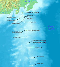
English: High quality map of the Izu Islands. This is the English (Romaji) version with Japanese names. Created with DEMIS World Map Server.
日本語: 日本語:高品質の地図、伊豆諸島。 |
| Tarix | |
| Mənbə | Öz işi |
| Müəllif | Artanisen |
| Digər versiyalar |
|

Lisenziya
This image is in the public domain because it came from the site https://www.demis.nl/products/web-map-server/examples/ and was released by the copyright holder. Permission is granted to copy, distribute and/or modify this map since it is based on free of copyright images from: www.demis.nl. See also approval email on de.wp and its clarification.
|
| This work has been released into the public domain by its copyright holder, www.demis.nl. This applies worldwide. In some countries this may not be legally possible; if so: www.demis.nl grants anyone the right to use this work for any purpose, without any conditions, unless such conditions are required by law.
|
This map image could be re-created using vector graphics as an SVG file. This has several advantages; see Commons:Media for cleanup for more information. If an SVG form of this image is available, please upload it and afterwards replace this template with
{{vector version available|new image name}}.It is recommended to name the SVG file “Map of Izu Islands.svg”—then the template Vector version available (or Vva) does not need the new image name parameter. |
Faylın tarixçəsi
Faylın əvvəlki versiyasını görmək üçün gün/tarix bölməsindəki tarixlərə klikləyin.
| Tarix/Vaxt | Miniatür | Ölçülər | İstifadəçi | Şərh | |
|---|---|---|---|---|---|
| hal-hazırkı | 01:04, 24 dekabr 2021 | | 1.257 × 1.409 (691 KB) | Artanisen | Reverted to version as of 10:15, 2 October 2019 (UTC) reverted to names in English only, because there is a separate Japanese map |
| 07:22, 21 oktyabr 2019 |  | 1.257 × 1.409 (771 KB) | Artanisen | Added Japanese kanji of the island names and thinner black lines. | |
| 10:15, 2 oktyabr 2019 |  | 1.257 × 1.409 (691 KB) | Artanisen | English: High quality map of the Izu Islands. Created with DEMIS World Map Server. 日本語:高品質の地図、伊豆諸島。 | |
| 14:51, 5 oktyabr 2006 |  | 300 × 400 (32 KB) | Tdk~commonswiki | Map of Izu Islands. Created with DEMIS World Map Server.{{demis-pd}} |
Faylın istifadəsi
Aşağıdakı səhifə bu faylı istifadə edir:
Faylın qlobal istifadəsi
Bu fayl aşağıdakı vikilərdə istifadə olunur:
- ar.wikipedia.org layihəsində istifadəsi
- ast.wikipedia.org layihəsində istifadəsi
- bn.wikipedia.org layihəsində istifadəsi
- ca.wikipedia.org layihəsində istifadəsi
- ceb.wikipedia.org layihəsində istifadəsi
- ckb.wikipedia.org layihəsində istifadəsi
- cs.wikipedia.org layihəsində istifadəsi
- da.wikipedia.org layihəsində istifadəsi
- dtp.wikipedia.org layihəsində istifadəsi
- el.wikipedia.org layihəsində istifadəsi
- en.wikipedia.org layihəsində istifadəsi
- Geography of Japan
- Tokyo
- List of islands of Japan
- Devil's Sea
- Izu Islands
- Nii-jima
- Kōzu-shima
- Portal:Japan
- Shikine-jima
- Izu Ōshima
- Mikura-jima
- Lot's Wife (crag)
- Aogashima
- Tori-shima (Izu Islands)
- Hachijō-kojima
- Smith Island (Japan)
- Inamba-jima
- Udone-shima
- Ōnohara Islands
- Bayonnaise Rocks
- Hachijō language
- Jinai-tō
- List of governors of the Nanpō Islands
- Seven Islands of Izu
- en.wikibooks.org layihəsində istifadəsi
- en.wikivoyage.org layihəsində istifadəsi
- eo.wikipedia.org layihəsində istifadəsi
- es.wikipedia.org layihəsində istifadəsi
Bu faylın qlobal istifadəsinə baxın.