
Sınaq göstərişi ölçüsü: 600 × 600 piksel. Digər ölçülər: 240 × 240 piksel | 480 × 480 piksel | 768 × 768 piksel | 1.024 × 1.024 piksel | 2.048 × 2.048 piksel | 4.055 × 4.055 piksel.
Faylın orijinalı (4.055 × 4.055 piksel, fayl həcmi: 15,2 MB, MIME növü: image/jpeg)
Bu fayl Vikianbarda yerləşir. Açıqlama səhifəsindəki məlumatlar aşağıda göstərilib. Vikianbar azad lisenziyalı media anbarıdır. Siz də töhfə verə bilərsiniz. |
Xülasə
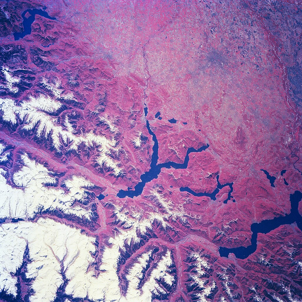
| İzah | Several elongated lakes (dark features) are identifiable in this southerly view of the Italian-Swiss border. The elongated lakes are the creation of alpine (or valley) glaciers that moved generally southward through this section of the Italian Alps over 12000 years ago. From west to east the four larger lakes are Maggiore (lower right corner), Lugana, Como, and d'Iseo (upper left corner). Smaller lakes (also dark features) are visible at the southern end of Lake Como (center of image) and Lake Maggiore. Subtle faults that are perpendicular to the southern end of the lakes can be traced east to west across the landscape at the base of the Italian Alps. Glaciated, U-shaped valleys are discernible north and northeast of the lakes. The color infrared helps to identify the densely vegetated mountain slopes where the forested land (green vegetation) is shown as concentrations of reddish patterns. The relatively flat plains of the highly industrialized and agriculturally productive Po River Valley (upper third of image) presents a dramatically different looking terrain than the snow covered mountainous region of northern Italy. |
| Tarix | Winter/Spring 1997 |
| Mənbə | Here |
| Müəllif | Image Science and Analysis Laboratory, NASA-Johnson Space Center. 18 Mar. 2005. "Earth from Space - Image Information." |
This image or video was catalogued by one of the centers of the United States National Aeronautics and Space Administration (NASA) under Photo ID: NM23-776-834. This tag does not indicate the copyright status of the attached work. A normal copyright tag is still required. See Commons:Licensing. Other languages:
|
Lisenziya
| This file is in the public domain in the United States because it was solely created by NASA. NASA copyright policy states that "NASA material is not protected by copyright unless noted". (See Template:PD-USGov, NASA copyright policy page or JPL Image Use Policy.) | ||
 |
Warnings:
|
Faylın tarixçəsi
Faylın əvvəlki versiyasını görmək üçün gün/tarix bölməsindəki tarixlərə klikləyin.
| Tarix/Vaxt | Miniatür | Ölçülər | İstifadəçi | Şərh | |
|---|---|---|---|---|---|
| hal-hazırkı | 21:18, 24 iyul 2023 | | 4.055 × 4.055 (15,2 MB) | Don-vip | |
| 19:05, 5 avqust 2006 |  | 639 × 639 (391 KB) | Lange~commonswiki | {{Information |Description= Several elongated lakes (dark features) are identifiable in this southerly view of the Italian-Swiss border. The elongated lakes are the creation of alpine (or valley) glaciers that moved generally southward through this sectio |
Faylın istifadəsi
Aşağıdakı səhifə bu faylı istifadə edir:
Faylın qlobal istifadəsi
Bu fayl aşağıdakı vikilərdə istifadə olunur:
- ar.wikipedia.org layihəsində istifadəsi
- arz.wikipedia.org layihəsində istifadəsi
- ast.wikipedia.org layihəsində istifadəsi
- be.wikipedia.org layihəsində istifadəsi
- bg.wikipedia.org layihəsində istifadəsi
- ca.wikipedia.org layihəsində istifadəsi
- cy.wikipedia.org layihəsində istifadəsi
- de.wikivoyage.org layihəsində istifadəsi
- diq.wikipedia.org layihəsində istifadəsi
- el.wikipedia.org layihəsində istifadəsi
- fi.wikipedia.org layihəsində istifadəsi
- fr.wikipedia.org layihəsində istifadəsi
- fr.wikivoyage.org layihəsində istifadəsi
- ga.wikipedia.org layihəsində istifadəsi
- gd.wikipedia.org layihəsində istifadəsi
- gl.wikipedia.org layihəsində istifadəsi
- he.wikipedia.org layihəsində istifadəsi
- hy.wikipedia.org layihəsində istifadəsi
- ia.wikipedia.org layihəsində istifadəsi
- id.wikipedia.org layihəsində istifadəsi
- ilo.wikipedia.org layihəsində istifadəsi
- it.wikipedia.org layihəsində istifadəsi
- ka.wikipedia.org layihəsində istifadəsi
- ku.wikipedia.org layihəsində istifadəsi
- la.wikipedia.org layihəsində istifadəsi
- mzn.wikipedia.org layihəsində istifadəsi
- nn.wikipedia.org layihəsində istifadəsi
- no.wikipedia.org layihəsində istifadəsi
- oc.wikipedia.org layihəsində istifadəsi
- pl.wikipedia.org layihəsində istifadəsi
- ro.wikipedia.org layihəsində istifadəsi
- ru.wikipedia.org layihəsində istifadəsi
- ru.wikinews.org layihəsində istifadəsi
- sl.wikipedia.org layihəsində istifadəsi
- sr.wikipedia.org layihəsində istifadəsi
- tt.wikipedia.org layihəsində istifadəsi
- vec.wikipedia.org layihəsində istifadəsi
- vi.wikipedia.org layihəsində istifadəsi
- www.wikidata.org layihəsində istifadəsi