Butun axtardiqlarinizi tapmaq ucun buraya: DAXIL OLUN
  Mp4 Mp3 Axtar Yukle
  Video Axtar Yukle
  Shekil Axtar Yukle
  Informasiya Melumat Axtar
  Hazir Inshalar Toplusu
  AZERI CHAT + Tanishliq
  1-11 Sinif Derslikler Yukle
  Saglamliq Tibbi Melumat
  Whatsapp Plus Yukle(Yeni)

  • Ana səhifə
  • Təsadüfi
  • Yaxınlıqdakılar
  • Daxil ol
  • Nizamlamalar
İndi ianə et Əgər Vikipediya sizin üçün faydalıdırsa, bu gün ianə edin.

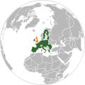
Fayl:Location map of the United Kingdom and the European Union.svg

  • Fayl
  • Müzakirə
  • Vikianbar üzərindən baxış
  • Lokal izah əlavə et
  • Fayl
  • Faylın tarixçəsi
  • Faylın istifadəsi
  • Faylın qlobal istifadəsi
  • Metaməlumatlar
Fayl:Location map of the United Kingdom and the European Union.svg
Bu SVG-faylın PNG formatındakı bu görünüşünün ölçüsü: 587 × 600 piksel. Digər ölçülər: 235 × 240 piksel | 470 × 480 piksel | 752 × 768 piksel | 1.002 × 1.024 piksel | 2.004 × 2.048 piksel | 593 × 606 piksel.
Faylın orijinalı (SVG faylı, nominal olaraq 593 × 606 piksel, faylın ölçüsü: 708 KB)
Bu fayl Vikianbarda yerləşir. Açıqlama səhifəsindəki məlumatlar aşağıda göstərilib.
Vikianbar azad lisenziyalı media anbarıdır. Siz də töhfə verə bilərsiniz.

Xülasə

İzahLocation map of the United Kingdom and the European Union.svg
Deutsch: Lage des Vereinigten Königreichs in der Europäischen Union 2016.
English: Location of the United Kingdom and the European Union
 
United Kingdom
 
EU member states
 
Other countries
Tarix 11 yanvar 2016
Mənbə This file was derived from: EU Single Market.svg: 
Müəllif Furfur
İcazə
(Faylın təkrar istifadəsi)
Public domainPublic domainfalsefalse
Public domain This map is ineligible for copyright and therefore in the public domain, because it consists entirely of information that is common property and contains no original authorship. For more information, see Commons:Threshold of originality § Maps.

English | Español | Galego | Română | slovenščina | العربية | 简体中文 | 繁體中文 | +/−

SVG genesis
InfoField
 
The SVG code is valid.
 
This map was created with Inkscape.
Valide/Erzeugt mit
InfoField

Başlıqlar

Bu faylın nəyi təmsil etdiyinə dair bir sətirlik izahat əlavə et
The UK (orange) and the European Union (blue)
Storbrittanien och EU
Localização do Reino Unido na União Europeia
Birleşik Krallık (turuncu) ve Avrupa Birliği (mavi)
Het VK (oranje) en de Europese Unie (blauw)
پادشاهی متحده (نارنجی) و اتحادیهٔ اروپا (آبی)

Bu faylda təsvir olunan elementlər

təsvir edir

Birləşmiş Krallıq

Avropa İttifaqı

yaranma tarixi

11 yanvar 2016

media type ingilis

image/svg+xml

Faylın tarixçəsi

Faylın əvvəlki versiyasını görmək üçün gün/tarix bölməsindəki tarixlərə klikləyin.

(ən yeni | ən əvvəlki) Göstər (10 daha yeni | 10 daha köhnə) (10 | 20 | 50 | 100 | 250 | 500).
Tarix/VaxtMiniatürÖlçülərİstifadəçiŞərh
hal-hazırkı10:10, 27 dekabr 202210:10, 27 dekabr 2022 tarixindəki versiyanın miniatür görüntüsü593 × 606 (708 KB)IktsokhCorrection of borders
03:03, 27 mart 201903:03, 27 mart 2019 tarixindəki versiyanın miniatür görüntüsü593 × 606 (702 KB)Nice4WhatReverted to version as of 08:03, 28 August 2016 (UTC) Northern Cyprus is shown as part as Cyprus in all other EU maps
16:55, 2 fevral 201716:55, 2 fevral 2017 tarixindəki versiyanın miniatür görüntüsü593 × 606 (704 KB)RaviCShaded regions with partial EU treaty application (Customs Union) per https://www.gov.uk/government/uploads/system/uploads/attachment_data/file/588948/The_United_Kingdoms_exit_from_and_partnership_with_the_EU_Web.pdf
05:52, 29 avqust 201605:52, 29 avqust 2016 tarixindəki versiyanın miniatür görüntüsü593 × 606 (704 KB)TurnlessReverted to version as of 12:49, 25 June 2016 (UTC) COM:OVERWRITE violation, you can create a new map if you'd like.
08:03, 28 avqust 201608:03, 28 avqust 2016 tarixindəki versiyanın miniatür görüntüsü593 × 606 (702 KB)BazonkaNorthern Cyprus is de jure part of the EU
12:49, 25 iyun 201612:49, 25 iyun 2016 tarixindəki versiyanın miniatür görüntüsü593 × 606 (704 KB)SteinsplitterReverted to version as of 17:57, 18 June 2016 (UTC): COM:OVERWRITE violation
12:08, 25 iyun 201612:08, 25 iyun 2016 tarixindəki versiyanın miniatür görüntüsü792 × 792 (2,87 MB)ThiefOfBagdadFull EU view
17:57, 18 iyun 201617:57, 18 iyun 2016 tarixindəki versiyanın miniatür görüntüsü593 × 606 (704 KB)RaviC+ Gib
05:37, 16 iyun 201605:37, 16 iyun 2016 tarixindəki versiyanın miniatür görüntüsü593 × 606 (703 KB)TurnlessUpdate layout
10:30, 27 may 201610:30, 27 may 2016 tarixindəki versiyanın miniatür görüntüsü632 × 637 (765 KB)Furfurnew color, better visibility
(ən yeni | ən əvvəlki) Göstər (10 daha yeni | 10 daha köhnə) (10 | 20 | 50 | 100 | 250 | 500).

Faylın istifadəsi

Aşağıdakı səhifə bu faylı istifadə edir:

  • Böyük Britaniyanın Avropa İttifaqından çıxışı

Faylın qlobal istifadəsi

Bu fayl aşağıdakı vikilərdə istifadə olunur:

  • af.wikipedia.org layihəsində istifadəsi
    • 2016
    • Brexit
  • ar.wikipedia.org layihəsində istifadəsi
    • مفاوضات خروج المملكة المتحدة من الاتحاد الأوروبي
    • اتفاقية بريكست
    • اتفاق التجارة والتعاون بين الاتحاد الأوروبي والمملكة المتحدة
    • المفاوضات التجارية بين المملكة المتحدة والاتحاد الأوروبي
  • ast.wikipedia.org layihəsində istifadəsi
    • Salida del Reinu Xuníu de la Xunión Europea
  • bar.wikipedia.org layihəsində istifadəsi
    • 2016
  • ba.wikipedia.org layihəsində istifadəsi
    • Европа тарихы
  • be.wikipedia.org layihəsində istifadəsi
    • Выхад Вялікабрытаніі з Еўрапейскага саюза
  • bg.wikipedia.org layihəsində istifadəsi
    • Председателство на Съвета на ЕС
    • Излизане на Великобритания от Европейския съюз
  • bh.wikipedia.org layihəsində istifadəsi
    • ब्रेक्जिट
  • bn.wikipedia.org layihəsində istifadəsi
    • ব্রেক্সিট
  • br.wikipedia.org layihəsində istifadəsi
    • Brexit
  • bs.wikipedia.org layihəsində istifadəsi
    • Brexit
  • cs.wikipedia.org layihəsində istifadəsi
    • Dohoda mezi EU a Spojeným královstvím o obchodu a spolupráci
  • cy.wikipedia.org layihəsində istifadəsi
    • Brexit
    • Ôl-Brexit a'r cynlluniau i adael yr Undeb Ewropeaidd
  • da.wikipedia.org layihəsində istifadəsi
    • Folkeafstemningen om Storbritanniens EU-medlemskab 2016
  • de.wikipedia.org layihəsində istifadəsi
    • 2016
    • Benutzer:Kallewirsch
    • EU-Austritt des Vereinigten Königreichs
    • Benutzer:Tmid
    • Benutzer:Anton-kurt/Schaufenster 2016
    • Wikipedia:Hauptseite/Archiv/24. Juni 2016
    • Wikipedia:Hauptseite/Archiv/3. November 2016
    • März 2017
    • Wikipedia:Hauptseite/Archiv/29. März 2017
    • Wikipedia:Kartenwerkstatt/Archiv/2017-04
    • Wikipedia:Hauptseite/Archiv/20. Juni 2017
    • Wikipedia:Hauptseite/Archiv/15. November 2018
    • Wikipedia:Hauptseite/Archiv/25. November 2018
    • Wikipedia:Hauptseite/Archiv/26. November 2018
    • EU-Mitgliedschaft des Vereinigten Königreichs
    • Wikipedia:Kurier/Ausgabe 2 2020
    • Handels- und Kooperationsabkommen zwischen der Europäischen Union und dem Vereinigten Königreich
    • Benutzer:Gabas/Meistaufgerufene Artikel
  • din.wikipedia.org layihəsində istifadəsi
    • Brɛ̈kdhït
  • diq.wikipedia.org layihəsində istifadəsi
    • Brexit
  • en.wikipedia.org layihəsində istifadəsi
    • User:ArcMachaon/sandbox
    • Brexit
    • Wikipedia:In the news/Candidates/June 2016
    • Template talk:United Kingdom in the European Union
    • Wikipedia:Top 25 Report/June 19 to 25, 2016
    • Wikipedia:Wikipedia Signpost/2016-07-04/Traffic report
    • Wikipedia:Wikipedia Signpost/Single/2016-07-04
    • Wikipedia:Top 25 Report/June 26 to July 2, 2016
    • Talk:Brexit/Archive 1
    • Brexit negotiations

Bu faylın qlobal istifadəsinə baxın.

Metaməlumatlar

Bu faylda fotoaparat və ya skanerlə əlavə olunmuş məlumatlar var. Əgər fayl sonradan olunubsa, bəzi parametrlər bu şəkildə göstərilənlərdən fərqli ola bilər.

Qısa başlıqCountries of Europe
Şəkil başlığıA blank Map of Europe. Every country has an id which is its ISO-3166-1-ALPHA2 code in lower case.
Members of the EU have a class="eu", countries in europe (which I found turkey to be but russia not) have a class="europe".
Certain countries are further subdivided the United Kingdom has gb-gbn for Great Britain and gb-nir for Northern Ireland. Russia is divided into ru-kgd for the Kaliningrad Oblast and ru-main for the Main body of Russia. There is the additional grouping #xb for the "British Islands" (the UK with its Crown Dependencies - Jersey, Guernsey and the Isle of Man) and the Kingdom of Denmark (Denmark, Faroe Islands, Greenland)

Contributors.
Original Image: (http://commons.wikimedia.org/wiki/Image:Europe_countries.svg) Júlio Reis (http://commons.wikimedia.org/wiki/User:Tintazul).
Recolouring and tagging with country codes: Marian "maix" Sigler (http://commons.wikimedia.org/wiki/User:Maix)
Improved geographical features: http://commons.wikimedia.org/wiki/User:W!B:
Updated to reflect dissolution of Serbia & Montenegro: http://commons.wikimedia.org/wiki/User:Zirland
Updated to include British Crown Dependencies as seperate entities and regroup them as "British Islands", with some simplifications to the XML and CSS: James Hardy (http://commons.wikimedia.org/wiki/User:MrWeeble)
Validated (http://commons.wikimedia.org/wiki/User:CarolSpears)
Changed the country code of Serbia to RS per http://en.wikipedia.org/wiki/Serbian_country_codes and the file http://www.iso.org/iso/iso3166_en_code_lists.txt (http://commons.wikimedia.org/wiki/User:TimothyBourke)
Uploaded on behalf of User:Checkit, direct complaints to him plox: 'Moved countries out of the "outlines" group, removed "outlines" style class, remove separate style information for Russia' (http://commons.wikimedia.org/wiki/User:Collard)
Updated various coastlines and boarders and added various islands not previously shown (details follow). Added Kosovo, Northern Cyprus, Crimea, Abkhazia, South Ossetia, Transnistria and Nagorno-Karabakh as disputed territories. Moved major lakes to their own object and added more. List of updated boarders/coastlines: British Isles (+ added Isle of Wight, Skye, various smaller islands), the Netherlands, Germany, Austria, Hungary, Czech Republic, Denmark, Sweden, Finland, Poland, Kaliningrad Oblast of the Russian Federation (and minor tweaks to Lithuania), Estonia, Ukraine, Moldova (minor), Romania, Bulgaria, Turkey, Greece, F.Y.R. Macedonia, Serbia, Bosnia and Herzegovina, Montenegro, Albania, Croatia, Italy (mainland and Sicily), Malta (http://commons.wikimedia.org/wiki/User:Alphathon).
Added Bornholm (http://commons.wikimedia.org/wiki/User:Heb)

Released under CreativeCommons Attribution ShareAlike (http://creativecommons.org/licenses/by-sa/2.5/).
Genişlik593
Hündürlük606
Mənbə — "https://az.wikipedia.org/wiki/Fayl:Location_map_of_the_United_Kingdom_and_the_European_Union.svg"
Informasiya Melumat Axtar