
Bu SVG-faylın PNG formatındakı bu görünüşünün ölçüsü: 485 × 340 piksel. Digər ölçülər: 320 × 224 piksel | 640 × 449 piksel | 1.024 × 718 piksel | 1.280 × 897 piksel | 2.560 × 1.795 piksel.
Faylın orijinalı (SVG faylı, nominal olaraq 485 × 340 piksel, faylın ölçüsü: 1,23 MB)
Bu fayl Vikianbarda yerləşir. Açıqlama səhifəsindəki məlumatlar aşağıda göstərilib. Vikianbar azad lisenziyalı media anbarıdır. Siz də töhfə verə bilərsiniz. |
Xülasə


.svg)
.svg)
.svg)
.svg)
.svg)


.svg)
.svg)
.svg)


.png)
.png)


.svg)


.svg)

.svg)


.svg)
.svg)
.svg)
.svg)


.svg)
.png)


.svg)


.svg)
.svg)


.svg)


.svg)


.svg)
.svg)
.svg)
.svg)
.svg)
.svg)
.svg)
.svg)
_cropped.svg)
.svg)
.svg)
.svg)
.svg)
.svg)
.svg)
.svg)
.svg)
.svg)
.svg)
.svg)
.svg)
.svg)
.svg)
.svg)
.svg)
.svg)
.svg)
.svg)
.svg)
.svg)
.svg)
.svg)
.svg)
.svg)
.svg)
.svg)
.svg)
.svg)
.svg)
.svg)
.svg)
.svg)
.svg)
.svg)
.svg)
.svg)
.svg)
.svg)
.svg)
.svg)
.svg)
.svg)
.svg)
.svg)
Lisenziya
Bu fayl Creative Commons Attribution-Share Alike 4.0 Beynəlxalq lisenziyası altında yayımlanır.
- Siz heç bir məhdudiyyət olmadan:
- paylaşa bilərsiniz – əsəri köçürə, paylaya və ötürə bilərsiniz
- remiks edə bilərsiniz – əsəri adaptasiya edə bilərsiniz
- Aşağıdakı şərtlərə əməl etməklə:
- istinad vermək – Müvafiq istinad verməli, lisenziyaya keçid əlavə etməli və dəyişikliklər edilib-edilmədiyini bildirməlisiniz . Siz bunu istənilən şəkildə edə bilərsiniz, lakin lisenziya verənin sizə şəxsən icazə verdiyini göstərən formada yox.
- bənzər paylaşma – Əsəri remix edirsinizsə, dəyişdirirsinizsə və ya üzərində iş aparırsınızsa, öz töhfələrinizi orijinalda olduğu kimi eyni və ya uyğun lisenziya altında yayımlamalısınız.
Faylın tarixçəsi
Faylın əvvəlki versiyasını görmək üçün gün/tarix bölməsindəki tarixlərə klikləyin.
| Tarix/Vaxt | Miniatür | Ölçülər | İstifadəçi | Şərh | |
|---|---|---|---|---|---|
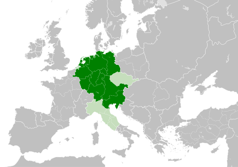
| hal-hazırkı | 11:49, 4 may 2021 | | 485 × 340 (1,23 MB) | E-960 | Tribute was paid under Mieszko I, by the year 1000 Bolesław I the Brave stopped paying it |
| 13:14, 23 may 2016 |  | 485 × 340 (1,23 MB) | Der Golem | Duchy of Bohemia was part of the Holy Roman Empire, but not within the Kingdom of Germany | |
| 20:19, 22 may 2016 |  | 485 × 340 (1,23 MB) | Alphathon | == {{int:filedesc}} == {{Inkscape}} {{Information |Description={{en|A map of the Kingdom of Germany within the Holy Roman Empire and within Europe circa 1004 CE, after the incorporation of the [[:en:Duchy of Bohemia|Duchy of... |
Faylın istifadəsi
Aşağıdakı səhifə bu faylı istifadə edir:
Faylın qlobal istifadəsi
Bu fayl aşağıdakı vikilərdə istifadə olunur:
- arz.wikipedia.org layihəsində istifadəsi
- ba.wikipedia.org layihəsində istifadəsi
- be.wikipedia.org layihəsində istifadəsi
- ca.wikipedia.org layihəsində istifadəsi
- cs.wikipedia.org layihəsində istifadəsi
- en.wikipedia.org layihəsində istifadəsi
- eo.wikipedia.org layihəsində istifadəsi
- es.wikipedia.org layihəsində istifadəsi
- et.wikipedia.org layihəsində istifadəsi
- eu.wikipedia.org layihəsində istifadəsi
- fr.wikipedia.org layihəsində istifadəsi
- id.wikipedia.org layihəsində istifadəsi
- ja.wikipedia.org layihəsində istifadəsi
- ko.wikipedia.org layihəsində istifadəsi
- la.wikipedia.org layihəsində istifadəsi
- lv.wikipedia.org layihəsində istifadəsi
- pl.wikipedia.org layihəsində istifadəsi
- ru.wikipedia.org layihəsində istifadəsi
- uk.wikipedia.org layihəsində istifadəsi
- www.wikidata.org layihəsində istifadəsi
.svg)