
Bu fayl Vikianbarda yerləşir. Açıqlama səhifəsindəki məlumatlar aşağıda göstərilib. Vikianbar azad lisenziyalı media anbarıdır. Siz də töhfə verə bilərsiniz. |
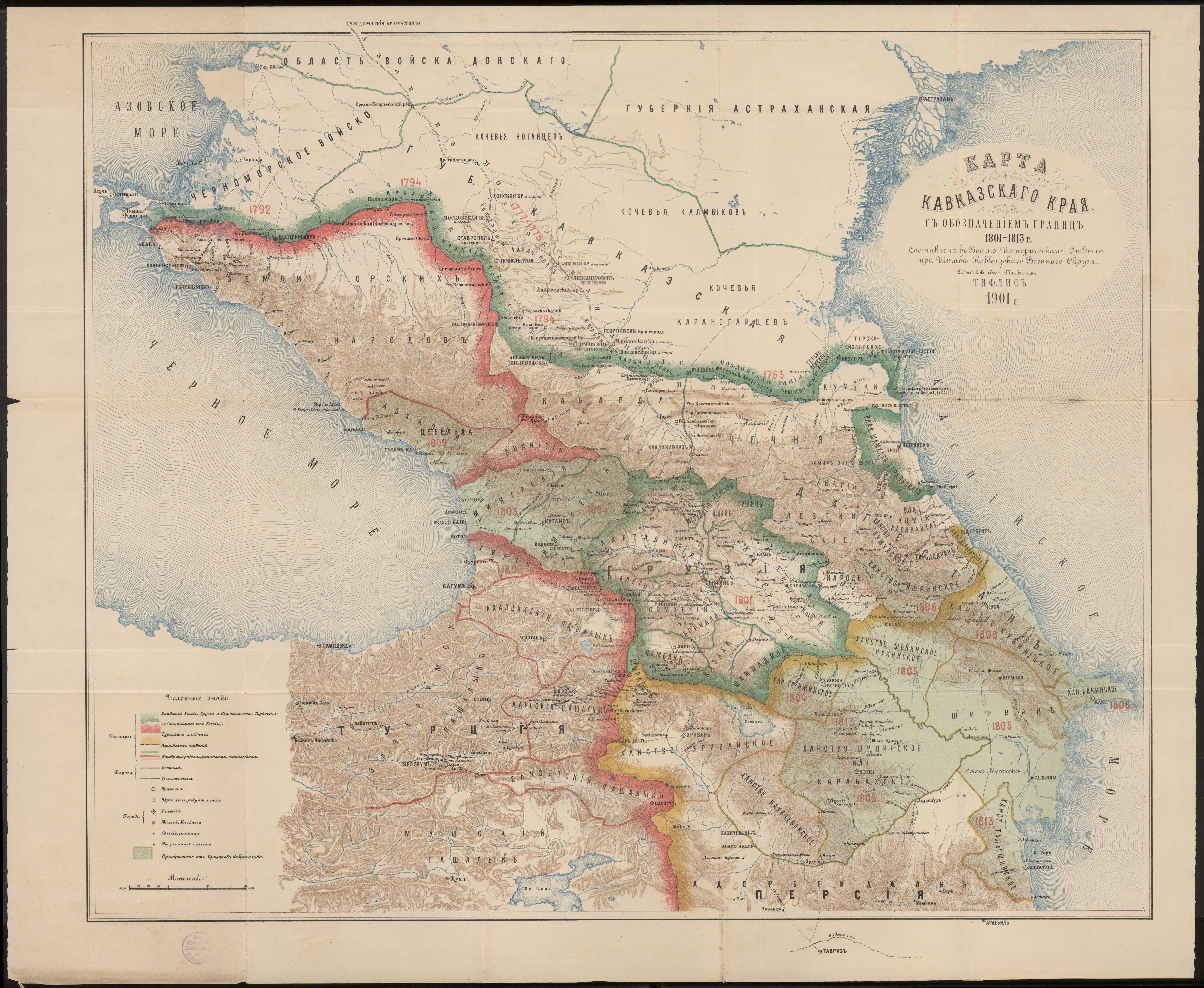
| İzah |
English: Khanate of Baku in the Map of Caucasus with the borders. |
| Tarix | |
| Mənbə | Карта Кавказского края с обозначением границ 1801-1813 г. Составлена в военно-историческом отделе при штабе Кавказского военного округа подполковником Томкиевым. Тифлис 1901 г. |
| Müəllif | Владимир Ильич Томкеев |
This work was published on territory of the Russian Empire (Russian Republic) except for territories of the Grand Duchy of Finland and Congress Poland before 7 November 1917 and wasn't re-published for 30 days following initial publications on the territory of Soviet Russia or any other countries.
The Russian Federation (early Soviet Russia, RSFSR) is the historical heir but not legal successor of the Russian Empire, and the Russian Empire was not party to the Berne Convention (it was not country of Union for the protection of the rights of authors in their literary and artistic works), so according to article 5 of the Convention this work has no country of origin except:
¹ - Author who is not a national of a country of the Union but who has his habitual residence in a country of the Union, be assimilated to national of that country. If applicable, {{PD-Russia-expired}} should be used instead of this tag. This work is in the public domain in the United States because it was published (or registered with the U.S. Copyright Office) before January 1, 1930. |
 |
Faylın tarixçəsi
Faylın əvvəlki versiyasını görmək üçün gün/tarix bölməsindəki tarixlərə klikləyin.
| Tarix/Vaxt | Miniatür | Ölçülər | İstifadəçi | Şərh | |
|---|---|---|---|---|---|
| hal-hazırkı | 20:14, 1 may 2020 | | 3.000 × 3.819 (3,26 MB) | Sword313 | Uploaded a work by Владимир Ильич Томкеев from [http://xn--b1aaibpv0aet4h1a.xn--p1ai/forums/uploads/gallery/album_19/gallery_4_19_4287845.jpg Карта Кавказского края с обозначением границ 1801-1813 г. Составлена в военно-историческом отделе при штабе Кавказского военного округа подполковником Томкиевым. Тифлис 1901 г.] with UploadWizard |
Faylın istifadəsi
Bu faylı istifadə edən səhifə yoxdur (digər layihələrdəki səhifələr göstərilmir).
Faylın qlobal istifadəsi
Bu fayl aşağıdakı vikilərdə istifadə olunur:
- ca.wikipedia.org layihəsində istifadəsi
- fa.wikipedia.org layihəsində istifadəsi
- fr.wikipedia.org layihəsində istifadəsi
- hy.wikipedia.org layihəsində istifadəsi
- it.wikipedia.org layihəsində istifadəsi
- nl.wikipedia.org layihəsində istifadəsi
- pt.wikipedia.org layihəsində istifadəsi
- ru.wikipedia.org layihəsində istifadəsi
- tr.wikipedia.org layihəsində istifadəsi
- uk.wikipedia.org layihəsində istifadəsi
- www.wikidata.org layihəsində istifadəsi