Butun axtardiqlarinizi tapmaq ucun buraya: DAXIL OLUN
  Mp4 Mp3 Axtar Yukle
  Video Axtar Yukle
  Shekil Axtar Yukle
  Informasiya Melumat Axtar
  Hazir Inshalar Toplusu
  AZERI CHAT + Tanishliq
  1-11 Sinif Derslikler Yukle
  Saglamliq Tibbi Melumat
  Whatsapp Plus Yukle(Yeni)

  • Ana səhifə
  • Təsadüfi
  • Yaxınlıqdakılar
  • Daxil ol
  • Nizamlamalar
İndi ianə et Əgər Vikipediya sizin üçün faydalıdırsa, bu gün ianə edin.

Fayl:ISS012-E-15982 - View of Italy.jpg

  • Fayl
  • Müzakirə
  • Vikianbar üzərindən baxış
  • Lokal izah əlavə et
  • Fayl
  • Faylın tarixçəsi
  • Faylın istifadəsi
  • Faylın qlobal istifadəsi
Fayl:ISS012-E-15982 - View of Italy.jpg
Sınaq göstərişi ölçüsü: 397 × 599 piksel. Digər ölçülər: 159 × 240 piksel | 318 × 480 piksel | 1.008 × 1.520 piksel.
Faylın orijinalı (1.008 × 1.520 piksel, fayl həcmi: 214 KB, MIME növü: image/jpeg)
Bu fayl Vikianbarda yerləşir. Açıqlama səhifəsindəki məlumatlar aşağıda göstərilib.
Vikianbar azad lisenziyalı media anbarıdır. Siz də töhfə verə bilərsiniz.

Xülasə

İzahISS012-E-15982 - View of Italy.jpg
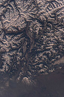
English: View of Italy taken during ISS Expedition 12.
Tarix 24 yanvar 2006, 12:46:01
Mənbə JSC Gateway to Astronaut Photography of Earth
Müəllif Earth Science and Remote Sensing Unit, Lyndon B. Johnson Space Center
Mission
InfoField
ISS012
Roll
InfoField
E
Frame
InfoField
15982
Geographic area
InfoField
Italy
Features
InfoField
ITALIAN ALPS, SNOWY, sunny PEAKS, main chain of the Alps in winter sun, Schnalskamm, Meran and Zillertaler Alpen region.
Cloud percentage
InfoField
10%
Altitude
InfoField
183 nautical miles (339 km)
Look angle
InfoField
22
Look direction
InfoField
SW
Sun Azimuth
InfoField
200°
Sun Elevation
InfoField
21°
Camera
InfoField
Kodak DCS760c Electronic Still Camera
Focal length
InfoField
50 mm
Camera location47° 36′ N, 11° 36′ E Edit this at Structured Data on Commons Kartographer map based on OpenStreetMap.View this and other nearby images on: OpenStreetMapinfo 47.600000; 11.600000
Object location46° 30′ N, 11° 00′ E Edit this at Structured Data on Commons Kartographer map based on OpenStreetMap.View this and other nearby images on: OpenStreetMapinfo 46.500000; 11.000000


This image or video was catalogued by Johnson Space Center of the United States National Aeronautics and Space Administration (NASA) under Photo ID: ISS012-E-15982.

This tag does not indicate the copyright status of the attached work. A normal copyright tag is still required. See Commons:Licensing.
Other languages:

Afrikaans ∙ العربية ∙ беларуская (тарашкевіца) ∙ български ∙ Bahaso Jambi ∙ català ∙ čeština ∙ dansk ∙ Deutsch ∙ English ∙ español ∙ فارسی ∙ français ∙ galego ∙ magyar ∙ հայերեն ∙ Bahasa Indonesia ∙ italiano ∙ 日本語 ∙ македонски ∙ മലയാളം ∙ Nederlands ∙ polski ∙ português ∙ русский ∙ sicilianu ∙ slovenščina ∙ Türkçe ∙ українська ∙ 简体中文 ∙ 繁體中文 ∙ +/−

Lisenziya

Public domainPublic domainfalsefalse
Public domain This file is in the public domain in the United States because it was solely created by NASA. NASA copyright policy states that "NASA material is not protected by copyright unless noted". (See Template:PD-USGov, NASA copyright policy page or JPL Image Use Policy.)
Warnings:
  • Use of NASA logos, insignia and emblems is restricted per U.S. law 14 CFR 1221.
  • The NASA website hosts a large number of images from the Soviet/Russian space agency, and other non-American space agencies. These are not necessarily in the public domain.
  • Materials based on Hubble Space Telescope data may be copyrighted if they are not explicitly produced by the STScI.[1] See also {{PD-Hubble}} and {{Cc-Hubble}}.
  • The SOHO (ESA & NASA) joint project implies that all materials created by its probe are copyrighted and require permission for commercial non-educational use. [2]
  • Images featured on the Astronomy Picture of the Day (APOD) web site may be copyrighted. [3]
  • The National Space Science Data Center (NSSDC) site has been known to host copyrighted content. Its photo gallery FAQ states that all of the images in the photo gallery are in the public domain "Unless otherwise noted."
Annotations
InfoField
This image is annotated: View the annotations at Commons
457
614
56
132
1008
1520

Überetsch

388
434
66
63
1008
1520

Meran

508
594
51
43
1008
1520

Bozen

485
312
122
244
1008
1520

Sarntaler Alpen

376
376
48
33
1008
1520

Kolbenspitze massif

84
485
279
58
1008
1520

Vinschgau (valley and region)

703
46
244
132
1008
1520

rötliche Wintersonne
(Januar)
mit harten Bergschatten in den Alpentälern
der Zillertaler Alpen

33
292
262
89
1008
1520

main chain of the Alps,
mountain chain Schnalskamm
(Oetztal Alps) in winter

744
140
129
74
1008
1520

Zillertaler Hauptkamm
(part of main chain of The Alps)

211
1330
698
122
1008
1520

North Italy (Italia)

406
576
66
226
1008
1520

Mendelkamm chain
(former glacier region)

744
459
226
190
1008
1520

Dolomiti mountains

399
929
66
63
1008
1520

Trento - Trient

221
1127
38
183
1008
1520

Lago di Garda

363
883
33
38
1008
1520

Paganella

Başlıqlar

Bu faylın nəyi təmsil etdiyinə dair bir sətirlik izahat əlavə et
View of Italy taken during ISS Expedition 12

Bu faylda təsvir olunan elementlər

təsvir edir

əhəmiyyətli hadisə

Expedition 12 ingilis

yaradıcı

Vikidata elementi olmayan bir neçə dəyər

obyektin rolu: fotoqraf
member of the crew of ingilis: Expedition 12 ingilis

copyright status ingilis

ictimai mülkiyyət

təyinetmə üsulu: work of the federal government of the United States ingilis

anlayışın sinfi

fotoqrafiya

kataloq kodu

ISS012-E-15982

kataloq: Media catalogue of the Johnson Space Center ingilis

yaranma tarixi

24 yanvar 2006

yaradılma yeri

Beynəlxalq Kosmik Stansiya

location of the point of view ingilis

Beynəlxalq Kosmik Stansiya

dəniz səviyyəsindən yüksəkliyi

183 dəniz mili

source of file ingilis

file available on the internet ingilis

URL-də təsvir edilmişdir: https://eol.jsc.nasa.gov/SearchPhotos/photo.pl?mission=ISS012&roll=E&frame=15982
istifadəçi: NASA

coordinates of depicted place ingilis

46°30'N, 11°0'E

coordinates of the point of view ingilis

47°36'N, 11°36'E

media type ingilis

image/jpeg

Faylın tarixçəsi

Faylın əvvəlki versiyasını görmək üçün gün/tarix bölməsindəki tarixlərə klikləyin.

Tarix/VaxtMiniatürÖlçülərİstifadəçiŞərh
hal-hazırkı17:10, 7 noyabr 202217:10, 7 noyabr 2022 tarixindəki versiyanın miniatür görüntüsü1.008 × 1.520 (214 KB)SteinsplitterBotBot: Image rotated by 270°
22:35, 27 sentyabr 202222:35, 27 sentyabr 2022 tarixindəki versiyanın miniatür görüntüsü1.520 × 1.008 (212 KB)AskeBot

Faylın istifadəsi

Aşağıdakı səhifə bu faylı istifadə edir:

  • Trentino-Alto Adice

Faylın qlobal istifadəsi

Bu fayl aşağıdakı vikilərdə istifadə olunur:

  • ar.wikipedia.org layihəsində istifadəsi
    • ترينتينو ألتو أديجي
  • ast.wikipedia.org layihəsində istifadəsi
    • Trentino-Alto Adige
  • be.wikipedia.org layihəsində istifadəsi
    • Трэнціна — Альта-Адыджэ
  • ca.wikipedia.org layihəsində istifadəsi
    • Trentino - Tirol del Sud
  • cy.wikipedia.org layihəsində istifadəsi
    • Trentino-Alto Adige
  • de.wikivoyage.org layihəsində istifadəsi
    • Trentino-Südtirol
    • Oberitalien
  • diq.wikipedia.org layihəsində istifadəsi
    • Trentino-Alto Adice
  • el.wikipedia.org layihəsində istifadəsi
    • Τρεντίνο-Άλτο Άντιτζε
  • fi.wikipedia.org layihəsində istifadəsi
    • Trentino-Etelä-Tiroli
  • fr.wikivoyage.org layihəsində istifadəsi
    • Trentin-Haut-Adige
  • ga.wikipedia.org layihəsində istifadəsi
    • Trentino-Tirol Theas
  • gd.wikipedia.org layihəsində istifadəsi
    • Trentino-Alto Adige/Südtirol
  • gl.wikipedia.org layihəsində istifadəsi
    • Trentino-Tirol do Sur
  • ia.wikipedia.org layihəsində istifadəsi
    • Trentino-Alto Adige
  • id.wikipedia.org layihəsində istifadəsi
    • Trentino-Tirol Selatan
  • ka.wikipedia.org layihəsində istifadəsi
    • ტრენტინო-ალტო-ადიჯე
  • ku.wikipedia.org layihəsində istifadəsi
    • Trentino-Alto Adige/Südtirol
  • lb.wikipedia.org layihəsində istifadəsi
    • Trentino-Südtiroul
  • lmo.wikipedia.org layihəsində istifadəsi
    • Trentin-Süd Tirol
  • mzn.wikipedia.org layihəsində istifadəsi
    • ترنتینو آلتو آدیجه
  • nn.wikipedia.org layihəsində istifadəsi
    • Trentino-Alto Adige
  • no.wikipedia.org layihəsində istifadəsi
    • Trentino-Syd-Tirol
  • oc.wikipedia.org layihəsində istifadəsi
    • Trentin-Aut Adige
  • pl.wikipedia.org layihəsində istifadəsi
    • Trydent-Górna Adyga
  • ps.wikipedia.org layihəsində istifadəsi
    • ترنتینو التو ادیجه
  • ro.wikipedia.org layihəsində istifadəsi
    • Trentino-Tirolul de Sud
  • ru.wikipedia.org layihəsində istifadəsi
    • Трентино-Альто-Адидже
  • ru.wikinews.org layihəsində istifadəsi
    • Категория:Трентино-Альто-Адидже
  • sr.wikipedia.org layihəsində istifadəsi
    • Трентино-Јужни Тирол
  • tt.wikipedia.org layihəsində istifadəsi
    • Трентино-Альто-Адиҗе
  • uk.wikipedia.org layihəsində istifadəsi
    • Трентіно-Альто-Адідже
  • vec.wikipedia.org layihəsində istifadəsi
    • Trentin-Alto Àdeze
  • vi.wikipedia.org layihəsində istifadəsi
    • Trentino-Nam Tirol
  • www.wikidata.org layihəsində istifadəsi
    • Q1237
Mənbə — "https://az.wikipedia.org/wiki/Fayl:ISS012-E-15982_-_View_of_Italy.jpg"
Informasiya Melumat Axtar