Butun axtardiqlarinizi tapmaq ucun buraya: DAXIL OLUN
  Mp4 Mp3 Axtar Yukle
  Video Axtar Yukle
  Shekil Axtar Yukle
  Informasiya Melumat Axtar
  Hazir Inshalar Toplusu
  AZERI CHAT + Tanishliq
  1-11 Sinif Derslikler Yukle
  Saglamliq Tibbi Melumat
  Whatsapp Plus Yukle(Yeni)

  • Ana səhifə
  • Təsadüfi
  • Yaxınlıqdakılar
  • Daxil ol
  • Nizamlamalar
İndi ianə et Əgər Vikipediya sizin üçün faydalıdırsa, bu gün ianə edin.

Fayl:Hudson bay explorer.png

  • Fayl
  • Müzakirə
  • Vikianbar üzərindən baxış
  • Lokal izah əlavə et
  • Fayl
  • Faylın tarixçəsi
  • Faylın istifadəsi
  • Faylın qlobal istifadəsi
Fayl:Hudson bay explorer.png
Daha yüksək versiyası yoxdur.
Hudson_bay_explorer.png (550 × 442 piksel, fayl həcmi: 449 KB, MIME növü: image/png)
Bu fayl Vikianbarda yerləşir. Açıqlama səhifəsindəki məlumatlar aşağıda göstərilib.
Vikianbar azad lisenziyalı media anbarıdır. Siz də töhfə verə bilərsiniz.
İzahHudson bay explorer.png
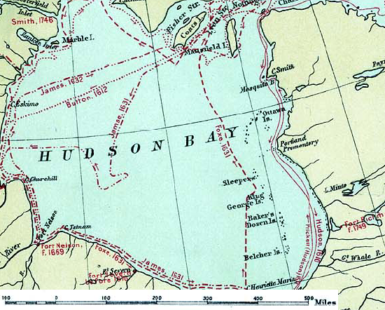
English: Map of the routes of the main European explorers in Hudson Bay, Canada.
Tarix 1906
Mənbə Excerpted from 1st Edition, 1906, Atlas of Canada - Routes of Explorers,1497 to 1905.
Müəllif Department of the Interior, Ottawa
İcazə
(Faylın təkrar istifadəsi)

Crown copyright expired.

Public domainPublic domainfalsefalse
Public domain
This Canadian work is in the public domain in Canada because its copyright has expired due to one of the following:
1. It was subject to Crown copyright and was first published more than 50 years ago, or

it was not subject to Crown copyright, and

2. it is a photograph that was created prior to January 1, 1949, or
3. the creator died prior to January 1, 1972.

You must also include a United States public domain tag to indicate why this work is in the public domain in the United States.
 Note that this work might not be in the public domain in countries that do not apply the rule of the shorter term and have copyright terms longer than life of the author plus 50 years. In particular, Mexico is 100 years, Jamaica is 95 years, Colombia is 80 years, Guatemala and Samoa are 75 years, Switzerland and the United States are 70 years, and Venezuela is 60 years.

العربية ∙ বাংলা ∙ čeština ∙ Deutsch ∙ English ∙ español ∙ suomi ∙ français ∙ italiano ∙ 日本語 ∙ 한국어 ∙ македонски ∙ മലയാളം ∙ Nederlands ∙ português ∙ português do Brasil ∙ sicilianu ∙ slovenščina ∙ 简体中文 ∙ 繁體中文 ∙ +/−

Public domainPublic domainfalsefalse
Public domain
This work is in the public domain in the United States because it was published (or registered with the U.S. Copyright Office) before January 1, 1930.

Public domain works must be out of copyright in both the United States and in the source country of the work in order to be hosted on the Commons. If the work is not a U.S. work, the file must have an additional copyright tag indicating the copyright status in the source country.
Note: This tag should not be used for sound recordings.PD-1923Public domain in the United States//commons.wikimedia.org/wiki/File:Hudson_bay_explorer.png

Orijinal yükləmə gündəliyi

The original description page was here. All following user names refer to en.wikipedia.
  • 2007-01-26 22:28 CyclePat 550×442×8 (459278 bytes) ==Description== This map shows the routes followed by the principal explorers of what is now Canada, from 1497 up to 1905. The map also shows the location of forts with the date of their establishment. It was created using [[:image:Canada, Routes of Explo

Başlıqlar

Bu faylın nəyi təmsil etdiyinə dair bir sətirlik izahat əlavə et

Bu faylda təsvir olunan elementlər

təsvir edir

copyright status ingilis

ictimai mülkiyyət

yaranma tarixi

1906

media type ingilis

image/png

Faylın tarixçəsi

Faylın əvvəlki versiyasını görmək üçün gün/tarix bölməsindəki tarixlərə klikləyin.

Tarix/VaxtMiniatürÖlçülərİstifadəçiŞərh
hal-hazırkı11:41, 10 iyul 200811:41, 10 iyul 2008 tarixindəki versiyanın miniatür görüntüsü550 × 442 (449 KB)Urdangaray{{Information |Description={{en|thumb|400px|right|Canada, Routes of Explorers,1497 to 1905 This map shows the routes followed by the principal explorers of what is now Canada, from 1497 up to 190

Faylın istifadəsi

Aşağıdakı səhifə bu faylı istifadə edir:

  • Hudzon körfəzi

Faylın qlobal istifadəsi

Bu fayl aşağıdakı vikilərdə istifadə olunur:

  • arz.wikipedia.org layihəsində istifadəsi
    • خليج هادسون
  • ast.wikipedia.org layihəsində istifadəsi
    • Badea de Hudson
  • bg.wikipedia.org layihəsində istifadəsi
    • Хъдсън (залив)
  • ca.wikipedia.org layihəsində istifadəsi
    • Badia de Hudson
    • Thomas Button
  • cv.wikipedia.org layihəsində istifadəsi
    • Гудзон кӳлмекĕ
  • de.wikipedia.org layihəsində istifadəsi
    • Ottawa Islands
  • en.wikipedia.org layihəsində istifadəsi
    • Hudson Bay
    • Ottawa Islands
    • Portal:Maps/Maps/Nautical
    • Portal:Maps/Maps/Nautical/7
  • es.wikipedia.org layihəsində istifadəsi
    • Bahía de Hudson
    • Thomas Button
    • Anexo:Cronología de la exploración y colonización de América del Norte
  • hi.wikipedia.org layihəsində istifadəsi
    • हडसन खाड़ी
  • nn.wikipedia.org layihəsində istifadəsi
    • Hudsonbukta
  • ru.wikipedia.org layihəsində istifadəsi
    • Гудзонов залив
    • Баттон, Томас
  • zh.wikipedia.org layihəsində istifadəsi
    • 哈得孙湾
Mənbə — "https://az.wikipedia.org/wiki/Fayl:Hudson_bay_explorer.png"
Informasiya Melumat Axtar