Bu fayl Vikianbarda yerləşir. Açıqlama səhifəsindəki məlumatlar aşağıda göstərilib. Vikianbar azad lisenziyalı media anbarıdır. Siz də töhfə verə bilərsiniz. |
Xülasə
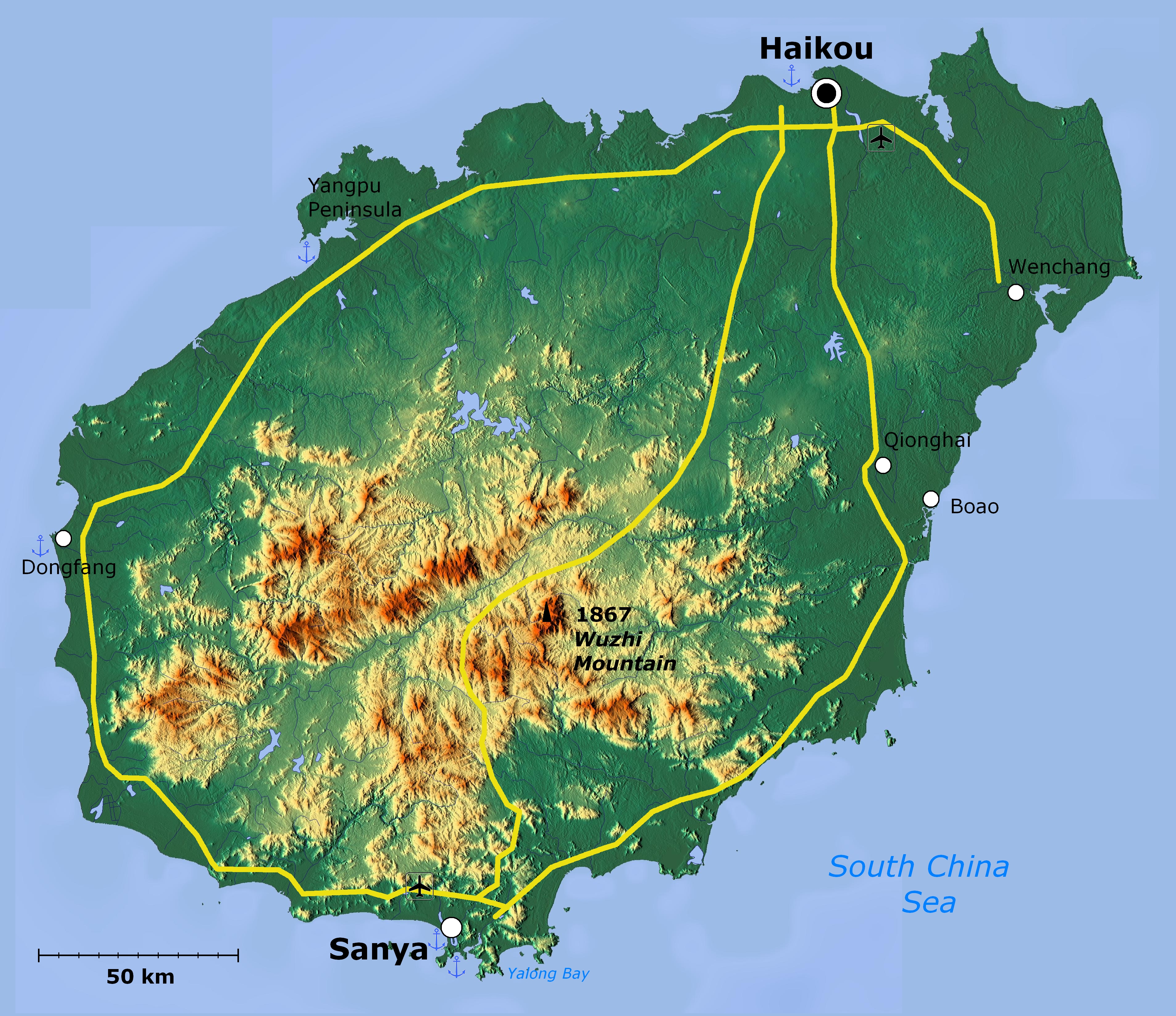
| İzah | Topographical map of Hainan Island — in Hainan Province, Southeast China. | ||
| Tarix | |||
| Mənbə | http://www.maps-for-free.com/ | ||
| Müəllif |
|
||
| İcazə (Faylın təkrar istifadəsi) |
http://www.maps-for-free.com/html/about.html
|
||
| Digər versiyalar |
This map image could be re-created using vector graphics as an SVG file. This has several advantages; see Commons:Media for cleanup for more information. If an SVG form of this image is available, please upload it and afterwards replace this template with
{{vector version available|new image name}}.It is recommended to name the SVG file “Hainan Island topographical.svg”—then the template Vector version available (or Vva) does not need the new image name parameter. |
Lisenziya
This screenshot either does not contain copyright-eligible parts or visuals of copyrighted software, or the author has released it under a free license (which should be indicated beneath this notice), and as such follows the licensing guidelines for screenshots of Wikimedia Commons. You may use it freely according to its particular license. Free software license:

|
Bu sənədi GNU Azad Sənədləşdirmə Lisenziyası, Versiya 1.2 və ya Azad Proqram Fondu tərəfindən nəşr olunan hər hansı sonrakı versiya şərtlərinə əsasən dəyişməz bölmələr, ön qapaq mətnləri və arxa qapaq mətnləri olmadan köçürmək, yayımlamaq və / və ya dəyişdirmək üçün icazə verilir; Lisenziyanın bir nüsxəsi GNU Azad Sənədləşdirmə Lisenziyası adlı hissəyə daxil edilmişdir. |
Note: if the screenshot shows any work that is not a direct result of the program code itself, such as a text or graphics that are not part of the program, the license for that work must be indicated separately.
Faylın tarixçəsi
Faylın əvvəlki versiyasını görmək üçün gün/tarix bölməsindəki tarixlərə klikləyin.
| Tarix/Vaxt | Miniatür | Ölçülər | İstifadəçi | Şərh | |
|---|---|---|---|---|---|
| hal-hazırkı | 02:39, 19 aprel 2011 | | 3.809 × 3.290 (6,14 MB) | Viriditas | Upload new version modified by Anna Frodesiak |
| 01:13, 2 aprel 2011 |  | 3.809 × 3.290 (6,34 MB) | Guerillero | {{convert to SVG|map}} {{Information |Description=Hainan Island, China - topographical map |Source=http://www.maps-for-free.com/ |Date=2011-04-02 |Author=Modified by Anna Frodesiak |Permission=http://www.maps-for-free.com/html/about.html |other_versions= |
Faylın istifadəsi
Aşağıdakı səhifə bu faylı istifadə edir:
Faylın qlobal istifadəsi
Bu fayl aşağıdakı vikilərdə istifadə olunur:
- af.wikipedia.org layihəsində istifadəsi
- ar.wikipedia.org layihəsində istifadəsi
- be.wikipedia.org layihəsində istifadəsi
- en.wikipedia.org layihəsində istifadəsi
- et.wikipedia.org layihəsində istifadəsi
- fi.wikipedia.org layihəsində istifadəsi
- hy.wikipedia.org layihəsində istifadəsi
- ja.wikipedia.org layihəsində istifadəsi
- mn.wikipedia.org layihəsində istifadəsi
- ru.wikipedia.org layihəsində istifadəsi
- ru.wiktionary.org layihəsində istifadəsi
- vi.wikipedia.org layihəsində istifadəsi
- zh-min-nan.wikipedia.org layihəsində istifadəsi
- Hái-lâm-séng
- Hái-kháu-chhī
- Sam-a-chhī
- Bûn-chhiong-chhī
- Ngó͘-chí-san-chhī
- Sam-soa-chhī
- Tam-chiu-chhī
- Khêng-hái-chhī
- Bān-lêng-chhī
- Tang-hng-chhī
- Tēng-an-koān
- Pang-bô͘:Hái-lâm ê hêng-chèng-khu
- Lîm-ko-koān
- Têng-māi-koān
- Tūn-chhiong-koān
- Chhiong-kang Lê-cho̍k Chū-tī-koān
- Pe̍k-soa Lê-cho̍k Chū-tī-koān
- Khêng-tiong Lê-cho̍k Biâu-cho̍k Chū-tī-koān
- Lêng-chúi Lê-cho̍k Chū-tī-koān
- Pó-têng Lê-cho̍k Biâu-cho̍k Chū-tī-koān
- Lo̍k-tong Lê-cho̍k Chū-tī-koān
- Bí-lân-khu
- Khêng-san-khu
- Liông-hoâ-khu (Hái-kháu)
- Siù-eng-khu
- Kiat-iông-khu
- Hái-tông-khu
- Thian-gâi-khu
- Gâi-chiu-khu
- zh.wikipedia.org layihəsində istifadəsi
Bu faylın qlobal istifadəsinə baxın.