Butun axtardiqlarinizi tapmaq ucun buraya: DAXIL OLUN
  Mp4 Mp3 Axtar Yukle
  Video Axtar Yukle
  Shekil Axtar Yukle
  Informasiya Melumat Axtar
  Hazir Inshalar Toplusu
  AZERI CHAT + Tanishliq
  1-11 Sinif Derslikler Yukle
  Saglamliq Tibbi Melumat
  Whatsapp Plus Yukle(Yeni)

  • Ana səhifə
  • Təsadüfi
  • Yaxınlıqdakılar
  • Daxil ol
  • Nizamlamalar
İndi ianə et Əgər Vikipediya sizin üçün faydalıdırsa, bu gün ianə edin.

Fayl:Godavari satellite view.jpg

  • Fayl
  • Müzakirə
  • Vikianbar üzərindən baxış
  • Lokal izah əlavə et
  • Fayl
  • Faylın tarixçəsi
  • Faylın istifadəsi
  • Faylın qlobal istifadəsi
  • Metaməlumatlar
Fayl:Godavari satellite view.jpg
Sınaq göstərişi ölçüsü: 600 × 600 piksel. Digər ölçülər: 240 × 240 piksel | 480 × 480 piksel | 768 × 768 piksel | 1.024 × 1.024 piksel | 2.048 × 2.048 piksel | 5.248 × 5.248 piksel.
Faylın orijinalı (5.248 × 5.248 piksel, fayl həcmi: 8,05 MB, MIME növü: image/jpeg)
Bu fayl Vikianbarda yerləşir. Açıqlama səhifəsindəki məlumatlar aşağıda göstərilib.
Vikianbar azad lisenziyalı media anbarıdır. Siz də töhfə verə bilərsiniz.

Xülasə

İzahGodavari satellite view.jpg
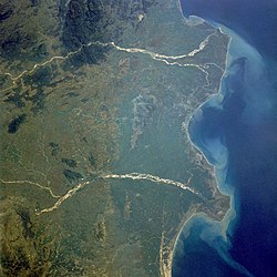
Français : les deltas de la Godavari et de la Krishna.
English: Godavari and Krishna River Deltas in South India — the mouths of the Godavari River (northeast; upper in image) and the Krishna River (southwest, lower in image) empty into the Bay of Bengal in this low-oblique, northwest-looking photograph (October 1989).
  • The two rivers have several common characteristics—they are quite wide and have conspicuous deltas, both have heavy discharges of water during the monsoon season (June to early September) followed by low discharges during the dry season (October through late May), both discharge sediment into the Bay of Bengal, and both are sacred rivers of the Hindu religion.
  • The Godavari River — 900 miles (1450 kilometers) long, rises in the Western Ghats and flows across the Deccan Plateau toward the Bay of Bengal in eastern India. Below the city of Rajahmundry, the river divides into two streams that form the huge delta named Pasarlapudi, which is the site of some of the earliest European settlements in India.
  • The Krishna River — more than 800 miles (1290 kilometers) long, also rises in the Western Ghats only 40 miles (64 kilometers) from the Arabian Sea. The river also traverses the Deccan Plateau and empties into the Bay of Bengal southwest of the Godavari River Delta.
Tarix oktyabr 1989
Mənbə

http://earth.jsc.nasa.gov/scripts/sseop/photo.pl?mission=STS034&roll=77&frame=29

  • Transferred from fr.wikipedia to Commons by Korrigan using CommonsHelper.
Müəllif Earth Sciences and Image Analysis, NASA-Johnson Space Center. 16 Sep. 2004. "Earth from Space"
This image or video was catalogued by one of the centers of the United States National Aeronautics and Space Administration (NASA) under Photo ID: STS034-077-029.

This tag does not indicate the copyright status of the attached work. A normal copyright tag is still required. See Commons:Licensing.
Other languages:

Afrikaans ∙ العربية ∙ беларуская (тарашкевіца) ∙ български ∙ Bahaso Jambi ∙ català ∙ čeština ∙ dansk ∙ Deutsch ∙ English ∙ español ∙ فارسی ∙ français ∙ galego ∙ magyar ∙ հայերեն ∙ Bahasa Indonesia ∙ italiano ∙ 日本語 ∙ македонски ∙ മലയാളം ∙ Nederlands ∙ polski ∙ português ∙ русский ∙ sicilianu ∙ slovenščina ∙ Türkçe ∙ українська ∙ 简体中文 ∙ 繁體中文 ∙ +/−

Lisenziya

Public domainPublic domainfalsefalse
Public domain This file is in the public domain in the United States because it was solely created by NASA. NASA copyright policy states that "NASA material is not protected by copyright unless noted". (See Template:PD-USGov, NASA copyright policy page or JPL Image Use Policy.)
Warnings:
  • Use of NASA logos, insignia and emblems is restricted per U.S. law 14 CFR 1221.
  • The NASA website hosts a large number of images from the Soviet/Russian space agency, and other non-American space agencies. These are not necessarily in the public domain.
  • Materials based on Hubble Space Telescope data may be copyrighted if they are not explicitly produced by the STScI.[1] See also {{PD-Hubble}} and {{Cc-Hubble}}.
  • The SOHO (ESA & NASA) joint project implies that all materials created by its probe are copyrighted and require permission for commercial non-educational use. [2]
  • Images featured on the Astronomy Picture of the Day (APOD) web site may be copyrighted. [3]
  • The National Space Science Data Center (NSSDC) site has been known to host copyrighted content. Its photo gallery FAQ states that all of the images in the photo gallery are in the public domain "Unless otherwise noted."

Orijinal yükləmə gündəliyi

The original description page was here. All following user names refer to fr.wikipedia.
  • 2004-09-19 21:40 Nataraja 640×640× (131443 bytes) les deltas de la Godâvarî et de la Krishnâ

Başlıqlar

Bu faylın nəyi təmsil etdiyinə dair bir sətirlik izahat əlavə et
Godavari- ja Krishnajokien suistot

Bu faylda təsvir olunan elementlər

təsvir edir

Yer

əhəmiyyətli hadisə

STS-34 ingilis

copyright status ingilis

ictimai mülkiyyət

yurisdiksiyasındadır: Amerika Birləşmiş Ştatları
təyinetmə üsulu: work of the federal government of the United States ingilis

yaranma tarixi

oktyabr 1989

media type ingilis

image/jpeg

Faylın tarixçəsi

Faylın əvvəlki versiyasını görmək üçün gün/tarix bölməsindəki tarixlərə klikləyin.

Tarix/VaxtMiniatürÖlçülərİstifadəçiŞərh
hal-hazırkı19:27, 4 mart 201819:27, 4 mart 2018 tarixindəki versiyanın miniatür görüntüsü5.248 × 5.248 (8,05 MB)Ras67levels adjusted
19:24, 4 mart 201819:24, 4 mart 2018 tarixindəki versiyanın miniatür görüntüsü5.248 × 5.248 (8,28 MB)Ras67high resolution
23:11, 21 oktyabr 200823:11, 21 oktyabr 2008 tarixindəki versiyanın miniatür görüntüsü640 × 640 (128 KB)File Upload Bot (Magnus Manske) {{BotMoveToCommons|fr.wikipedia}} {{Information |Description={{fr|les deltas de la Godâvarî et de la Krishnâ STS034-077-029 Godavari and Krishna River Deltas, India October 1989 The mouths of the Godavari River (east) and the Krishna River (wes

Faylın istifadəsi

Aşağıdakı səhifə bu faylı istifadə edir:

  • Andhra Pradeş

Faylın qlobal istifadəsi

Bu fayl aşağıdakı vikilərdə istifadə olunur:

  • af.wikipedia.org layihəsində istifadəsi
    • Godavari
    • Krisjna (rivier)
  • ar.wikipedia.org layihəsində istifadəsi
    • أندرا برديش
  • arz.wikipedia.org layihəsində istifadəsi
    • اندرا براديش
  • ast.wikipedia.org layihəsində istifadəsi
    • Andhra Pradesh
  • be.wikipedia.org layihəsində istifadəsi
    • Андхра-Прадэш
  • bh.wikipedia.org layihəsində istifadəsi
    • नदी
  • br.wikipedia.org layihəsində istifadəsi
    • Krishna (stêr)
  • ca.wikipedia.org layihəsində istifadəsi
    • Delta fluvial
    • Andhra Pradesh
    • Godavari
  • ce.wikipedia.org layihəsində istifadəsi
    • Андхра-Прадеш
  • cy.wikipedia.org layihəsində istifadəsi
    • Andhra Pradesh
  • de.wikivoyage.org layihəsində istifadəsi
    • Südindien
    • Andhra Pradesh
  • el.wikipedia.org layihəsində istifadəsi
    • Άντρα Πραντές
    • Γκοντάβαρι ποταμός
  • en.wikipedia.org layihəsində istifadəsi
    • Godavari River
    • False Divi Point
    • Polavaram Project
    • Pasarlapudi
  • en.wiktionary.org layihəsində istifadəsi
    • Godavari
  • eo.wikipedia.org layihəsində istifadəsi
    • Godavari
  • es.wikipedia.org layihəsində istifadəsi
    • Delta fluvial
    • Río Godavari
    • Cuenca de Krishna-Godavari
  • eu.wikipedia.org layihəsində istifadəsi
    • Andhra Pradesh
  • fi.wikipedia.org layihəsində istifadəsi
    • Andhra Pradesh
  • fr.wikipedia.org layihəsində istifadəsi
    • Pasarlapudi
  • fr.wikivoyage.org layihəsində istifadəsi
    • Andhra Pradesh
  • ga.wikipedia.org layihəsində istifadəsi
    • Andhra Pradesh
  • gl.wikipedia.org layihəsində istifadəsi
    • Andhra Pradesh
  • ha.wikipedia.org layihəsində istifadəsi
    • Andhra Pradesh
  • he.wikipedia.org layihəsində istifadəsi
    • אנדרה פרדש
  • hy.wikipedia.org layihəsində istifadəsi
    • Անդհրա Պրադեշ
  • id.wikipedia.org layihəsində istifadəsi
    • Story:Sungai terpanjang kedua setelah Sungai Gangga
  • it.wikipedia.org layihəsində istifadəsi
    • Delta fluviale
    • Godavari
  • ka.wikipedia.org layihəsində istifadəsi
    • ანდჰრა-პრადეში
  • ku.wikipedia.org layihəsində istifadəsi
    • Andhra Pradeş
  • mr.wikipedia.org layihəsində istifadəsi
    • त्रिभुज प्रदेश
  • ne.wikipedia.org layihəsində istifadəsi
    • गोदावरी नदी
  • new.wikipedia.org layihəsində istifadəsi
    • गोदावरी नदी
  • nn.wikipedia.org layihəsində istifadəsi
    • Andhra Pradesh
    • Godavari
  • no.wikipedia.org layihəsində istifadəsi
    • Andhra Pradesh
  • os.wikipedia.org layihəsində istifadəsi
    • Андхрæ-Прадеш
  • pa.wikipedia.org layihəsində istifadəsi
    • ਗੋਦਾਵਰੀ ਦਰਿਆ
  • pl.wikipedia.org layihəsində istifadəsi
    • Andhra Pradesh
  • pnb.wikipedia.org layihəsində istifadəsi
    • دریائے گوداوری

Bu faylın qlobal istifadəsinə baxın.

Metaməlumatlar

Bu faylda fotoaparat və ya skanerlə əlavə olunmuş məlumatlar var. Əgər fayl sonradan olunubsa, bəzi parametrlər bu şəkildə göstərilənlərdən fərqli ola bilər.

OrientasiyaNormal
Üfüqi xətt5.248 dpi
Şaquli xətt5.248 dpi
Proqram təminatıAdobe Photoshop
Faylın dəyişməsi tarixi və vaxtı19:38, 4 mart 2018
Rəng sahəsiFotoşəkildə rəng seçimi edilməmişdir.
Mənbə — "https://az.wikipedia.org/wiki/Fayl:Godavari_satellite_view.jpg"
Informasiya Melumat Axtar