Butun axtardiqlarinizi tapmaq ucun buraya: DAXIL OLUN
  Mp4 Mp3 Axtar Yukle
  Video Axtar Yukle
  Shekil Axtar Yukle
  Informasiya Melumat Axtar
  Hazir Inshalar Toplusu
  AZERI CHAT + Tanishliq
  1-11 Sinif Derslikler Yukle
  Saglamliq Tibbi Melumat
  Whatsapp Plus Yukle(Yeni)

  • Ana səhifə
  • Təsadüfi
  • Yaxınlıqdakılar
  • Daxil ol
  • Nizamlamalar
İndi ianə et Əgər Vikipediya sizin üçün faydalıdırsa, bu gün ianə edin.

Fayl:Gijeong-ri Flag.jpg

  • Fayl
  • Müzakirə
  • Lokal izah əlavə et
  • Fayl
  • Faylın tarixçəsi
  • Faylın istifadəsi
  • Faylın qlobal istifadəsi
  • Metaməlumatlar
Fayl:Gijeong-ri Flag.jpg
Sınaq göstərişi ölçüsü: 450 × 600 piksel. Digər ölçülər: 180 × 240 piksel | 360 × 480 piksel | 576 × 768 piksel | 768 × 1.024 piksel | 1.728 × 2.304 piksel.

Faylın orijinalı (1.728 × 2.304 piksel, fayl həcmi: 1,13 MB, MIME növü: image/jpeg)

Bu fayl Vikianbarda yerləşir. Açıqlama səhifəsindəki məlumatlar aşağıda göstərilib.
Vikianbar azad lisenziyalı media anbarıdır. Siz də töhfə verə bilərsiniz.

Xülasə

İzahGijeong-ri Flag.jpg
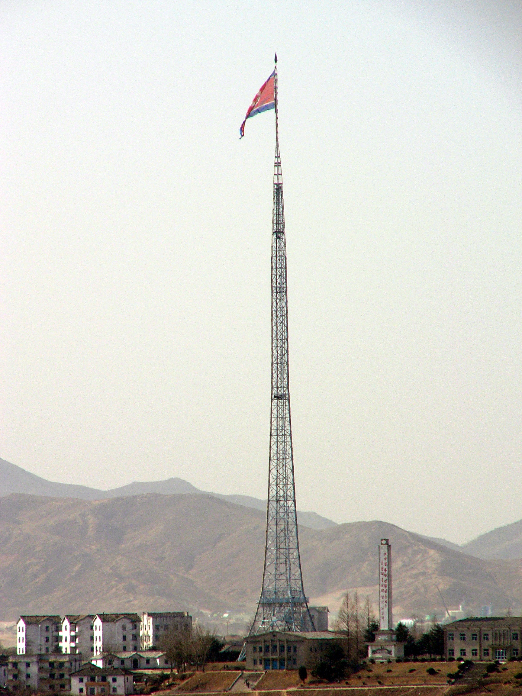
English: The world's fifth-tallest flagpole, flying the North Korean flag over Gijeong-ri, near Panmunjeom. Based on Panmunjeom north flagpole 2005 02 02.jpg – colour normalized
Tarix 5 iyun 2007 (original upload date)
Mənbə Transferred from en.wikipedia to Commons.
Müəllif The original uploader was Jpbarrass at ingilis Vikipediya.
Camera location37° 57′ 22,5″ N, 126° 40′ 27,08″ E Kartographer map based on OpenStreetMap.View this and other nearby images on: OpenStreetMapinfo 37.956250; 126.674190
Object location37° 56′ 43,19″ N, 126° 39′ 18,58″ E Kartographer map based on OpenStreetMap.View this and other nearby images on: OpenStreetMapinfo 37.945330; 126.655160

Lisenziya

Object
No copyright on artistic work
The depicted structure situated in or visible from public space (e.g. a building, a bridge, a signage) in North Korea North Korea is ineligible for copyright as it is a simple or ordinary work with no architectural or artistic properties that would have made it a copyrighted structure. It may also be a work of an engineer (like an infrastructure), not of an architect. In several countries like South Korea and the United States, bridges are not among their copyrightable works.
Notes:
  • Different jurisdictions have different levels of originality with regards to works of art or architecture: see Threshold of originality for more details.
  • In a few countries like France and Thailand, bridges may be among their copyrightable works.
  • A building or a bridge is eligible for copyright if it is a true architectural work; images of such buildings or bridges are not allowed on Wikimedia Commons unless there is an applicable freedom of panorama (that allows commercial uses) in the jurisdiction where the building or the bridge is located; see Commons:Freedom of panorama for more details.
  • For images of architecture that are in public domain, please use {{PD-old-architecture}}. Refer to its documentation for jurisdiction-specific tags.

English ∙ Tagalog ∙ 한국어 ∙ slovenščina ∙ +/−

Fotoqrafiya
w:az:Creative Commons
istinad vermək
Bu fayl Creative Commons Attribution 2.0 Generic lisenziyası altında yayımlanır.
Siz heç bir məhdudiyyət olmadan:
  • paylaşa bilərsiniz – əsəri köçürə, paylaya və ötürə bilərsiniz
  • remiks edə bilərsiniz – əsəri adaptasiya edə bilərsiniz
Aşağıdakı şərtlərə əməl etməklə:
  • istinad vermək – Müvafiq istinad verməli, lisenziyaya keçid əlavə etməli və dəyişikliklər edilib-edilmədiyini bildirməlisiniz . Siz bunu istənilən şəkildə edə bilərsiniz, lakin lisenziya verənin sizə şəxsən icazə verdiyini göstərən formada yox.
https://creativecommons.org/licenses/by/2.0CC BY 2.0 Creative Commons Attribution 2.0 truetrue

Orijinal yükləmə gündəliyi

The original description page was here. All following user names refer to en.wikipedia.
  • 2007-06-05 13:00 Jpbarrass 1728×2304×8 (1188881 bytes) The world's third tallest flagpole, flying the North Korean flag over Gijeong-ri, near Panmunjeom (37°56'30.24"N, 126°40'48.07"E) From a file already on Wikipedia - colour normalised

Başlıqlar

Bu faylın nəyi təmsil etdiyinə dair bir sətirlik izahat əlavə et

Bu faylda təsvir olunan elementlər

təsvir edir

copyright status ingilis

copyrighted ingilis

lisenziya

Creative Commons Attribution 2.0 Generic ingilis

captured with ingilis

Panasonic Lumix DMC-FZ10 ingilis

yaranma tarixi

5 iyun 2007

coordinates of the point of view ingilis

37°57'22.500"N, 126°40'27.084"E

coordinates of depicted place ingilis

37°56'43.188"N, 126°39'18.576"E

ISO speed ingilis

50

exposure time ingilis

0,00125 saniyə

f-number ingilis

5,6

focal length ingilis

72 millimetr

Faylın tarixçəsi

Faylın əvvəlki versiyasını görmək üçün gün/tarix bölməsindəki tarixlərə klikləyin.

Tarix/VaxtMiniatürÖlçülərİstifadəçiŞərh
hal-hazırkı12:44, 3 yanvar 200812:44, 3 yanvar 2008 tarixindəki versiyanın miniatür görüntüsü1.728 × 2.304 (1,13 MB)Redline{{Information |Description={{en|The world's tallest flagpole, flying the North Korean flag over Gijeong-ri, near Panmunjeom Based on en::image:Panmunjeom north flagpole 2005 02 02.jpg - colour normalised}} |Source=Transfered from [http://en.wikipedi

Faylın istifadəsi

Aşağıdakı səhifə bu faylı istifadə edir:

  • Bayraq dirəyi

Faylın qlobal istifadəsi

Bu fayl aşağıdakı vikilərdə istifadə olunur:

  • af.wikipedia.org layihəsində istifadəsi
    • Vlag
    • Vlag van Noord-Korea
  • ar.wikipedia.org layihəsində istifadəsi
    • المنطقة المنزوعة السلاح (كوريا)
  • be.wikipedia.org layihəsində istifadəsi
    • Кіджандон
    • Пханмунджом
  • bg.wikipedia.org layihəsində istifadəsi
    • Флагщок
    • Корейска демилитаризирана зона
  • bn.wikipedia.org layihəsində istifadəsi
    • কোরীয় সংঘাত
  • cy.wikipedia.org layihəsində istifadəsi
    • Baner Gogledd Corea
  • da.wikipedia.org layihəsində istifadəsi
    • Nordkoreas flag
    • Gijeong-dong
  • de.wikipedia.org layihəsində istifadəsi
    • Flagge Nordkoreas
    • Demilitarisierte Zone (Korea)
    • Fahnenmast
  • el.wikipedia.org layihəsində istifadəsi
    • Γκίτζονγκ-ντονγκ
  • en.wikipedia.org layihəsində istifadəsi
    • National flag
    • Wikipedia:Unusual articles
    • Flag of North Korea
    • Panmunjom
    • Korean Demilitarized Zone
    • Kijong-dong
    • Wikipedia:Unusual articles/Places and infrastructure
    • List of flagpoles by height
  • es.wikipedia.org layihəsində istifadəsi
    • Bandera de Corea del Norte
    • Kijŏng-dong
    • Conflicto coreano
  • et.wikipedia.org layihəsində istifadəsi
    • Panmunjom
  • fa.wikipedia.org layihəsində istifadəsi
    • پرچم کره شمالی
  • fr.wikipedia.org layihəsində istifadəsi
    • Zone coréenne démilitarisée
    • Conflit coréen
  • he.wikipedia.org layihəsində istifadəsi
    • תורן
  • hi.wikipedia.org layihəsində istifadəsi
    • कोरियाई विसैन्यीकृत क्षेत्र
  • hy.wikipedia.org layihəsində istifadəsi
    • Դրոշակաձող
  • it.wikipedia.org layihəsində istifadəsi
    • Zona demilitarizzata coreana
    • Kijŏng-dong
  • ja.wikipedia.org layihəsində istifadəsi
    • 朝鮮民主主義人民共和国の国旗
    • 軍事境界線 (朝鮮半島)
  • km.wikipedia.org layihəsində istifadəsi
    • ទង់ជាតិកូរ៉េខាងជើង
  • ko.wikipedia.org layihəsində istifadəsi
    • 조선민주주의인민공화국의 국기
    • 한반도 군사 분계선
    • 기 (상징)
    • 기정동
  • ky.wikipedia.org layihəsində istifadəsi
    • Кижондон
    • КЭДРдин туусу
  • lt.wikipedia.org layihəsində istifadəsi
    • Panmundžomas
  • lv.wikipedia.org layihəsində istifadəsi
    • Korejas Demilitarizētā zona
  • mn.wikipedia.org layihəsində istifadəsi
    • Солонгосын цэрэггүй бүс
  • my.wikipedia.org layihəsində istifadəsi
    • နိုင်ငံတော်အလံ
  • nds.wikipedia.org layihəsində istifadəsi
    • Flagg vun Noordkorea
  • nl.wikipedia.org layihəsində istifadəsi
    • Nationale vlag

Bu faylın qlobal istifadəsinə baxın.

Metaməlumatlar

Bu faylda fotoaparat və ya skanerlə əlavə olunmuş məlumatlar var. Əgər fayl sonradan olunubsa, bəzi parametrlər bu şəkildə göstərilənlərdən fərqli ola bilər.

Kamera istehsalçısıPanasonic
Kamera modeliDMC-FZ10
Exposure time1/800 saniyə (0,00125)
F nömrəsif/5,6
ISO sürət reytinqi50
Orijinal tarix və vaxt05:50, 2 fevral 2005
Fokus məsafəsi72 mm
OrientasiyaNormal
Üfüqi xətt72 dpi
Şaquli xətt72 dpi
Proqram təminatıVer1.05
Faylın dəyişməsi tarixi və vaxtı05:50, 2 fevral 2005
Y və C komponetlərinə görə yerləşmə sırasıCo-sited
Ekspozisiya proqramıNormal proqram
Exif versiyası2.2
Tarix və vaxt rəqəmləşdirilir05:50, 2 fevral 2005
Image compression mode4
APEX shutter speed9,644
Obyektiv gözü5
APEX exposure bias0
Maximum land aperture3 APEX (f/2,83)
Metering modeDizaynlı
İşıq mənbəsiSübh
FlaşFlaş yandırılmadı, compulsory flash suppression
Rəng sahəsisRGB
Sensing methodBirkristallı matrisli rəngli sensor
Custom image processingNormal proses
Exposure modeAvtomatik ekspozisiya
Ağ balansıBəyaz balansın avtomatik tənzimlənməsi
Digital zoom ratio0
Focal length in 35 mm film432 mm
Scene capture typeStandart
KontrastNormal
DoymuşluqNormal
KəskinlikAğır
Subject distance rangeUzaq məsafədən çəkiliş
Mənbə — "https://az.wikipedia.org/wiki/Fayl:Gijeong-ri_Flag.jpg"
Informasiya Melumat Axtar