Butun axtardiqlarinizi tapmaq ucun buraya: DAXIL OLUN
  Mp4 Mp3 Axtar Yukle
  Video Axtar Yukle
  Shekil Axtar Yukle
  Informasiya Melumat Axtar
  Hazir Inshalar Toplusu
  AZERI CHAT + Tanishliq
  1-11 Sinif Derslikler Yukle
  Saglamliq Tibbi Melumat
  Whatsapp Plus Yukle(Yeni)

  • Ana səhifə
  • Təsadüfi
  • Yaxınlıqdakılar
  • Daxil ol
  • Nizamlamalar
İndi ianə et Əgər Vikipediya sizin üçün faydalıdırsa, bu gün ianə edin.

Fayl:Florida Current map.jpg

  • Fayl
  • Müzakirə
  • Vikianbar üzərindən baxış
  • Lokal izah əlavə et
  • Fayl
  • Faylın tarixçəsi
  • Faylın istifadəsi
  • Faylın qlobal istifadəsi
Fayl:Florida Current map.jpg
Daha yüksək versiyası yoxdur.
Florida_Current_map.jpg (600 × 418 piksel, fayl həcmi: 40 KB, MIME növü: image/jpeg)
Bu fayl Vikianbarda yerləşir. Açıqlama səhifəsindəki məlumatlar aşağıda göstərilib.
Vikianbar azad lisenziyalı media anbarıdır. Siz də töhfə verə bilərsiniz.

Xülasə

İzahFlorida Current map.jpg
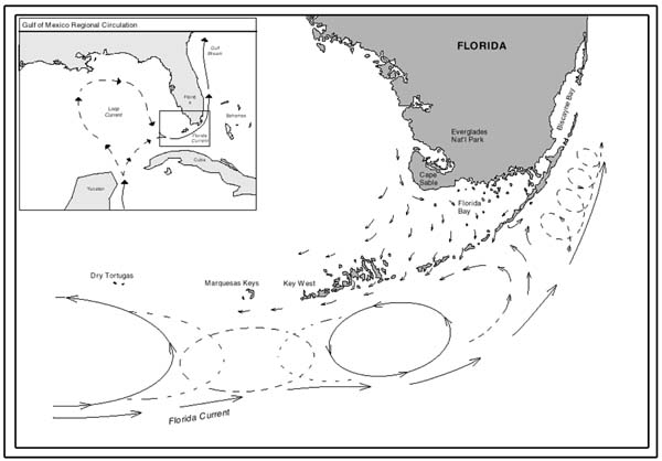
English: Map showing current patterns throughout the Florida Keys. Note how clockwise and counterclockwise gyres exist shoreward of the Florida Current.
Tarix 8 iyun 2010
Mənbə http://oceanexplorer.noaa.gov/explorations/islands01/background/wind/media/fl_currents.html
Müəllif National Oceanic and Atmospheric Administration
This geology image could be re-created using vector graphics as an SVG file. This has several advantages; see Commons:Media for cleanup for more information. If an SVG form of this image is available, please upload it and afterwards replace this template with {{vector version available|new image name}}.
It is recommended to name the SVG file “Florida Current map.svg”—then the template Vector version available (or Vva) does not need the new image name parameter.
This geology image was uploaded in the JPEG format even though it consists of non-photographic data. This information could be stored more efficiently or accurately in the PNG or SVG format. If possible, please upload a PNG or SVG version of this image without compression artifacts, derived from a non-JPEG source (or with existing artifacts removed). After doing so, please tag the JPEG version with {{Superseded|NewImage.ext}} and remove this tag. This tag should not be applied to photographs or scans. If this image is a diagram or other image suitable for vectorisation, please tag this image with {{Convert to SVG}} instead of {{BadJPEG}}. If not suitable for vectorisation, use {{Convert to PNG}}. For more information, see {{BadJPEG}}.

Lisenziya

Public domainPublic domainfalsefalse
Public domain
This image is in the public domain because it contains materials that originally came from the U.S. National Oceanic and Atmospheric Administration, taken or made as part of an employee's official duties.

العربية ∙ čeština ∙ Deutsch ∙ Zazaki ∙ English ∙ español ∙ eesti ∙ suomi ∙ français ∙ hrvatski ∙ magyar ∙ italiano ∙ 日本語 ∙ 한국어 ∙ македонски ∙ മലയാളം ∙ Plattdüütsch ∙ Nederlands ∙ polski ∙ português ∙ română ∙ русский ∙ sicilianu ∙ slovenščina ∙ Türkçe ∙ Tiếng Việt ∙ 简体中文 ∙ 繁體中文 ∙ +/−

Başlıqlar

Bu faylın nəyi təmsil etdiyinə dair bir sətirlik izahat əlavə et

Bu faylda təsvir olunan elementlər

təsvir edir

copyright status ingilis

ictimai mülkiyyət

yurisdiksiyasındadır: Amerika Birləşmiş Ştatları
təyinetmə üsulu: work of the federal government of the United States ingilis

yaranma tarixi

8 iyun 2010

Faylın tarixçəsi

Faylın əvvəlki versiyasını görmək üçün gün/tarix bölməsindəki tarixlərə klikləyin.

Tarix/VaxtMiniatürÖlçülərİstifadəçiŞərh
hal-hazırkı08:27, 12 dekabr 201708:27, 12 dekabr 2017 tarixindəki versiyanın miniatür görüntüsü600 × 418 (40 KB)InverseHypercubeUser created page with UploadWizard

Faylın istifadəsi

Aşağıdakı səhifə bu faylı istifadə edir:

  • Florida cərəyanı

Faylın qlobal istifadəsi

Bu fayl aşağıdakı vikilərdə istifadə olunur:

  • be.wikipedia.org layihəsində istifadəsi
    • Фларыдскае цячэнне
  • ca.wikipedia.org layihəsində istifadəsi
    • Corrent de Florida
  • cv.wikipedia.org layihəsində istifadəsi
    • Флорида юхăмĕ
  • de.wikipedia.org layihəsində istifadəsi
    • Floridastrom
  • en.wikipedia.org layihəsində istifadəsi
    • Florida Keys
    • Florida Current
  • es.wikipedia.org layihəsində istifadəsi
    • Corriente de Florida
  • et.wikipedia.org layihəsində istifadəsi
    • Florida hoovus
  • fa.wikipedia.org layihəsində istifadəsi
    • جریان فلوریدا
  • hr.wikipedia.org layihəsində istifadəsi
    • Floridska struja
  • it.wikipedia.org layihəsində istifadəsi
    • Corrente della Florida
  • ja.wikipedia.org layihəsində istifadəsi
    • フロリダ海流
  • nl.wikipedia.org layihəsində istifadəsi
    • Floridastroom
    • Gebruiker:Romaine/Zeestromen
  • nn.wikipedia.org layihəsində istifadəsi
    • Floridastraumen
  • pl.wikipedia.org layihəsində istifadəsi
    • Prąd Florydzki
  • pt.wikipedia.org layihəsində istifadəsi
    • Corrente da Flórida
  • ru.wikipedia.org layihəsində istifadəsi
    • Флоридское течение
  • sh.wikipedia.org layihəsində istifadəsi
    • Floridska struja
  • sr.wikipedia.org layihəsində istifadəsi
    • Флоридска струја
  • uk.wikipedia.org layihəsində istifadəsi
    • Флорида-Кіс
  • www.wikidata.org layihəsində istifadəsi
    • Q1263083
Mənbə — "https://az.wikipedia.org/wiki/Fayl:Florida_Current_map.jpg"
Informasiya Melumat Axtar