Sınaq göstərişi ölçüsü: 776 × 600 piksel. Digər ölçülər: 311 × 240 piksel | 621 × 480 piksel | 880 × 680 piksel.
Faylın orijinalı (880 × 680 piksel, fayl həcmi: 164 KB, MIME növü: image/jpeg)
Bu fayl Vikianbarda yerləşir. Açıqlama səhifəsindəki məlumatlar aşağıda göstərilib. Vikianbar azad lisenziyalı media anbarıdır. Siz də töhfə verə bilərsiniz. |
| İzah |
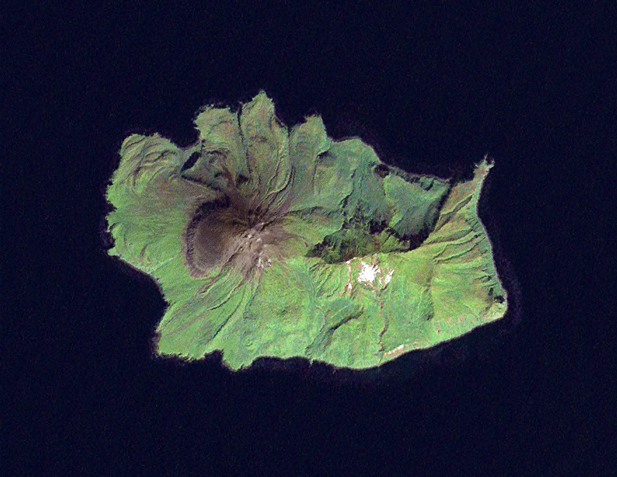
Čeština: Ekarma ( japonsky: 越渇磨島, Ekaruma-tó; rusky: Остров Зкарма) je jeden z ostrovů v Kurilském souostroví. Ekarma se rozkládá 8,5 km západně od ostrova Šiaškotan, za Ekarmskou úžinou, na ploše 30 km². Vystupuje strmě z moře jako vulkán (v západní části ostrova) až do maximální výšky 1 170 m. n. m.
English: Landsat 7 image of the Kuril Island of Ekarma, 14.25 meter resolution. Based on Global Orthorectified Landsat dataset (ETM+); WRS_PATH 101, WRS_ROW 026. Generated using panchromatic band for intensity, and color from "true-color" combination of 28.5 meter resolution bands 3, 2, & 1 (as R, G, B respectively). Data combined and color curves enhanced in the Gimp.
日本語: 越渇留磨島(エカルマ島、えかるまとう)は中部 千島、捨子古丹島から越渇留間海峡を挟んだ北西約5海里に位置する、東西約7.4km、幅約5.5kmの長方形の島である。全島で一山を形成していて、海抜は1179m。日本領時代は北海道根室支庁占守郡に属した。日本政府は国際法的には所属未定と主張しているが、ロシア連邦が実効支配している。ロシア名エカルマ島(о。Экарма)。
한국어: 예카르마 섬()는 중부 쿠릴 열도, 시아코탄 섬에서부터 예카르마 해협을 사이에 둔 북서 약 5 해리에 위치하는, 동서 약 7.4 km, 폭 5.5 km의 섬이다. 해발은 1179m이고 일본이 지배해을 때에는 홋카이도 네무로 지청 슈무슈 군에 속했다. 일본 정부는 소속 미정이라고 주장하고 있지만, 러시아가 실효 지배하고 있다.
Nederlands: Ekarma (Russisch: Остров Экарма; ostrov Ekarma; Japans: 越渇磨島; Ekaruma-tó) is een vulkanisch eiland dat deel uitmaakt van de noordelijke groep van de Grote Koerilen, onderdeel van de Koerilenarchipel, die onderdeel is van de Russische oblast Sachalin en die vroeger onderdeel was van Japan.
Русский: Экарма (яп. экарума-то) — остров в Северной группе Большой гряды Курильских островов. Как и другие острова архипелага административно входит в Сахалинскую область. Необитаем. |
|||||||
| Tarix | Data acquisition: 2000-09-11. Orthorectified version produced: 2002-12-04. Image created: 2007-02-04. | |||||||
| Mənbə | Data from USGS GloVis server http://glovis.usgs.gov/. Landsat Orthorectified data generated through NASA's Commercial Remote Sensing Program. | |||||||
| Müəllif | Data: NASA. Image: Dave Pape | |||||||
| İcazə (Faylın təkrar istifadəsi) |
|
|||||||
| Digər versiyalar | Image:Ekarma.png |
| Camera location | | View this and other nearby images on: OpenStreetMap |
|---|
Faylın tarixçəsi
Faylın əvvəlki versiyasını görmək üçün gün/tarix bölməsindəki tarixlərə klikləyin.
| Tarix/Vaxt | Miniatür | Ölçülər | İstifadəçi | Şərh | |
|---|---|---|---|---|---|
| hal-hazırkı | 19:34, 4 fevral 2007 | | 880 × 680 (164 KB) | Davepape | {{cs|'''Ekarma''' ( japonsky: 越渇磨島, ''Ekaruma-tó''; rusky: ''Остров Зкарма'') je jeden z ostrovů v Kurilském souostroví. Ekarma se rozkládá 8,5 km západně od [[:cs: |
Faylın istifadəsi
Bu faylı istifadə edən səhifə yoxdur (digər layihələrdəki səhifələr göstərilmir).
Faylın qlobal istifadəsi
Bu fayl aşağıdakı vikilərdə istifadə olunur:
- ace.wikipedia.org layihəsində istifadəsi
- af.wikipedia.org layihəsində istifadəsi
- ar.wikipedia.org layihəsində istifadəsi
- arz.wikipedia.org layihəsində istifadəsi
- be.wikipedia.org layihəsində istifadəsi
- bg.wikipedia.org layihəsində istifadəsi
- ca.wikipedia.org layihəsində istifadəsi
- ceb.wikipedia.org layihəsində istifadəsi
- da.wikipedia.org layihəsində istifadəsi
- de.wikipedia.org layihəsində istifadəsi
- en.wikipedia.org layihəsində istifadəsi
- es.wikipedia.org layihəsində istifadəsi
- eu.wikipedia.org layihəsində istifadəsi
- fa.wikipedia.org layihəsində istifadəsi
- fr.wikipedia.org layihəsində istifadəsi
- he.wikipedia.org layihəsində istifadəsi
- hr.wikipedia.org layihəsində istifadəsi
- it.wikipedia.org layihəsində istifadəsi
- ko.wikipedia.org layihəsində istifadəsi
- nl.wikipedia.org layihəsində istifadəsi
- nn.wikipedia.org layihəsində istifadəsi
- no.wikipedia.org layihəsində istifadəsi
- ru.wikipedia.org layihəsində istifadəsi
- tr.wikipedia.org layihəsində istifadəsi
- www.wikidata.org layihəsində istifadəsi
- zh.wikipedia.org layihəsində istifadəsi