Bu fayl Vikianbarda yerləşir. Açıqlama səhifəsindəki məlumatlar aşağıda göstərilib. Vikianbar azad lisenziyalı media anbarıdır. Siz də töhfə verə bilərsiniz. |
This historical map image could be re-created using vector graphics as an SVG file. This has several advantages; see Commons:Media for cleanup for more information. If an SVG form of this image is available, please upload it and afterwards replace this template with
{{vector version available|new image name}}.It is recommended to name the SVG file “East-Hem 1025ad.svg”—then the template Vector version available (or Vva) does not need the new image name parameter. |
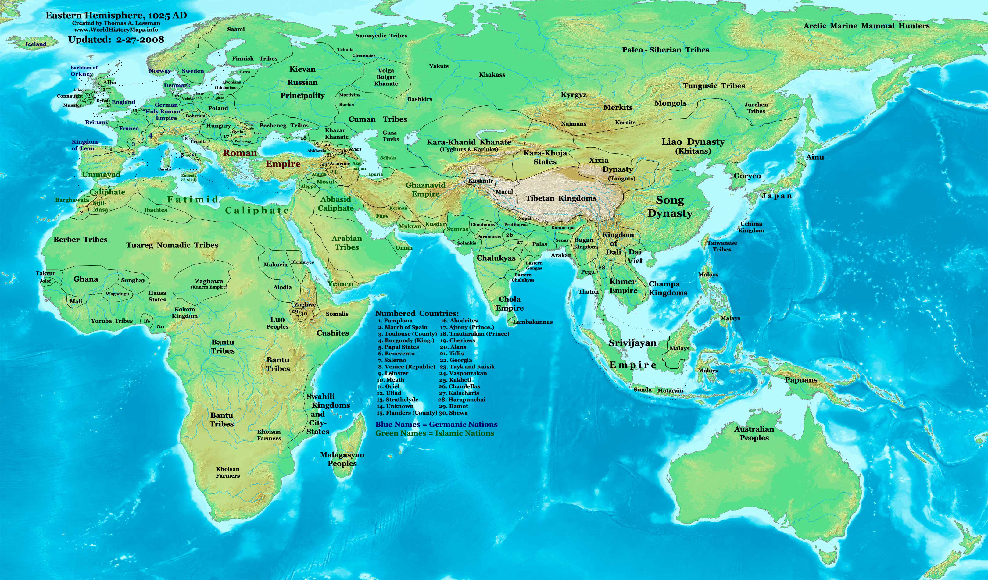
| İzah | Eastern Hemisphere in 1025 AD. |
| Mənbə | self-made (For reference information, see the Map Source References section below.) |
| Müəllif | Thomas Lessman (Contact!) |
| İcazə (Faylın təkrar istifadəsi) |
Mən, bu işin müəllif hüquqları sahibi, onu aşağıdakı lisenziyaya əsasən dərc edirəm: Bu fayl Creative Commons Attribution-Share Alike 3.0 Unported lisenziyası altında yayımlanır.
|
| Digər versiyalar | see East-Hem_1025ad.jpg file history on Wikipedia. |
Map Summary
Original Source URL: http://www.thomaslessman.com/History/images/East-Hem_1025ad.jpg.
This map of the Eastern Hemisphere in 1025 AD was created by Thomas Lessman, based on information from the sources listed below. This map is free for educational use (see Permission info above). When using this map, please mention that it is available for free at www.WorldHistoryMaps.info.
Map Source References
- Remember, sources often conflict with each other. This map is only as accurate as the information that is available to me. To report any errors or to help further this work, please click here, or email Thomas Lessman at talessman@yis.us
References for information contained in this map:
1. Borders of Europe are mostly derived from the www.Euratlas.com map of Europe in 1000 AD.
- (Please note: Bogomolov.PL has done a great job of showing me possible discrepancies in my north European borders compared to this source, due to the differences in the geographical layout of the maps.)
2. Borders of Asian countries derive from various Wikipedia articles and Google history map searches.
3. Fringe areas like Africa, Australia, Siberia, etc. derive from various articles in Wikipedia.
4. Much of the information in this map was cross-checked with Bruce Gordon's Regnal Chronologies archive copy at the Wayback Machine.
Other Maps by Thomas Lessman
| Maps of the eastern hemisphere showing history
Bold dates are available on Wikimedia or Wikipedia. | ||
| Primeval | ||
| Ancient
|
·| 600 BC | 550 BC | 527 BC | 500 BC |
400 BC | ·| 1 AD | 50 AD | 100 AD | 200 AD | 300 AD | | |
| Medieval |
·| 500 AD | 565 AD | 600 AD | 700 AD | | |
| Modern |
·| 1500 AD | · * For historical maps of the whole world, | |
Orijinal yükləmə gündəliyi
- 2008-01-21 22:17 Talessman 3240×1903×8 (795129 bytes) Corrected borders of Southeast Asia, Africa, Scandinavia, and added more info for East Asia and Africa.
- 2007-12-05 20:33 Talessman 3240×1903×8 (774637 bytes) Corrected borders for Mongolia, added names of smaller countries (with numbered legend), added more info for Africa, corrected information for Indonesia.
- 2007-11-09 15:14 Talessman 3240×1903×8 (727501 bytes) Corrected borders of Srivijaya, Sudan, and Ethiopia, also added info on other African tribes and nations, also added info for far eastern islands.
- 2007-09-26 16:26 Talessman 2880×1692×8 (571380 bytes) Author: Thomas A. Lessman. Source URL: http://www.ThomasLessman.com/History/images/East-Hem_1025ad.jpg. Image was created by me (Thomas Lessman) based on historical information located on Wikipedia, as well as information from maps located in Wikipedia an
- 2007-09-12 21:54 Talessman 2880×1692×8 (558662 bytes) Author: Thomas A. Lessman. Source URL: http://www.ThomasLessman.com/History/images/East-Hem_1025ad.jpg. Image was created by me (Thomas Lessman) based on historical information located on Wikipedia, as well as information from maps located in Wikipedia an
Faylın tarixçəsi
Faylın əvvəlki versiyasını görmək üçün gün/tarix bölməsindəki tarixlərə klikləyin.
| Tarix/Vaxt | Miniatür | Ölçülər | İstifadəçi | Şərh | |
|---|---|---|---|---|---|
| hal-hazırkı | 11:09, 16 yanvar 2009 | | 3.240 × 1.903 (3,16 MB) | Ukabia | {{Information |Description= |Source= |Date= |Author= |Permission= |other_versions= }} |
| 21:27, 9 may 2008 |  | 3.240 × 1.903 (778 KB) | Talessman | {{Information |Description=Eastern Hemisphere in 1025 AD. |Source=self-made |Author=User:Talessman |Permission={{self|cc-by-sa-3.0}} }} |
Faylın istifadəsi
Bu faylı istifadə edən səhifə yoxdur (digər layihələrdəki səhifələr göstərilmir).
Faylın qlobal istifadəsi
Bu fayl aşağıdakı vikilərdə istifadə olunur:
- ar.wikipedia.org layihəsində istifadəsi
- arz.wikipedia.org layihəsində istifadəsi
- azb.wikipedia.org layihəsində istifadəsi
- be.wikipedia.org layihəsində istifadəsi
- bs.wikipedia.org layihəsində istifadəsi
- ceb.wikipedia.org layihəsində istifadəsi
- de.wikipedia.org layihəsində istifadəsi
- de.wikiversity.org layihəsində istifadəsi
- en.wikipedia.org layihəsində istifadəsi
- es.wikipedia.org layihəsində istifadəsi
- fa.wikipedia.org layihəsində istifadəsi
- fr.wikipedia.org layihəsində istifadəsi
- gl.wikipedia.org layihəsində istifadəsi
- he.wikipedia.org layihəsində istifadəsi
- hu.wikipedia.org layihəsində istifadəsi
- io.wikipedia.org layihəsində istifadəsi
- lt.wikipedia.org layihəsində istifadəsi
- lv.wikipedia.org layihəsində istifadəsi
- mk.wikipedia.org layihəsində istifadəsi
- mr.wikipedia.org layihəsində istifadəsi
- my.wikipedia.org layihəsində istifadəsi
- pnb.wikipedia.org layihəsində istifadəsi
- ps.wikipedia.org layihəsində istifadəsi
- ro.wikipedia.org layihəsində istifadəsi
- rue.wikipedia.org layihəsində istifadəsi
- ru.wikipedia.org layihəsində istifadəsi
- shn.wikipedia.org layihəsində istifadəsi
- si.wikipedia.org layihəsində istifadəsi
- sv.wikipedia.org layihəsində istifadəsi
- sw.wikipedia.org layihəsində istifadəsi
- tg.wikipedia.org layihəsində istifadəsi
- th.wikipedia.org layihəsində istifadəsi
Bu faylın qlobal istifadəsinə baxın.