Butun axtardiqlarinizi tapmaq ucun buraya: DAXIL OLUN
  Mp4 Mp3 Axtar Yukle
  Video Axtar Yukle
  Shekil Axtar Yukle
  Informasiya Melumat Axtar
  Hazir Inshalar Toplusu
  AZERI CHAT + Tanishliq
  1-11 Sinif Derslikler Yukle
  Saglamliq Tibbi Melumat
  Whatsapp Plus Yukle(Yeni)

  • Ana səhifə
  • Təsadüfi
  • Yaxınlıqdakılar
  • Daxil ol
  • Nizamlamalar
İndi ianə et Əgər Vikipediya sizin üçün faydalıdırsa, bu gün ianə edin.

Fayl:Debris-GEO1280.jpg

  • Fayl
  • Müzakirə
  • Vikianbar üzərindən baxış
  • Lokal izah əlavə et
  • Fayl
  • Faylın tarixçəsi
  • Faylın istifadəsi
  • Faylın qlobal istifadəsi
Fayl:Debris-GEO1280.jpg
Sınaq göstərişi ölçüsü: 750 × 600 piksel. Digər ölçülər: 300 × 240 piksel | 600 × 480 piksel | 960 × 768 piksel | 1.280 × 1.024 piksel.
Faylın orijinalı (1.280 × 1.024 piksel, fayl həcmi: 125 KB, MIME növü: image/jpeg)
Bu fayl Vikianbarda yerləşir. Açıqlama səhifəsindəki məlumatlar aşağıda göstərilib.
Vikianbar azad lisenziyalı media anbarıdır. Siz də töhfə verə bilərsiniz.
İzahDebris-GEO1280.jpg
English: Debris plot by NASA.

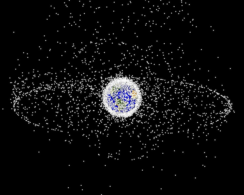
A computer-generated image of objects in Earth orbit that are currently being tracked. Approximately 95% of the objects in this illustration are orbital debris, i.e., not functional satellites. The dots represent the current location of each item. The orbital debris dots are scaled according to the image size of the graphic to optimize their visibility and are not scaled to Earth. The image provides a good visualization of where the greatest orbital debris populations exist.

This image is generated from a distant oblique vantage point to provide a good view of the object population in the geosynchronous region (around 35,785 km altitude). Note the larger population of objects over the northern hemisphere is due mostly to Russian objects in high-inclination, high-eccentricity orbits.
Mənbə NASA Orbital Debris Program Office, photo gallery
Müəllif NASA image
İcazə
(Faylın təkrar istifadəsi)
Public domainPublic domainfalsefalse
Public domain This file is in the public domain in the United States because it was solely created by NASA. NASA copyright policy states that "NASA material is not protected by copyright unless noted". (See Template:PD-USGov, NASA copyright policy page or JPL Image Use Policy.)
Warnings:
  • Use of NASA logos, insignia and emblems is restricted per U.S. law 14 CFR 1221.
  • The NASA website hosts a large number of images from the Soviet/Russian space agency, and other non-American space agencies. These are not necessarily in the public domain.
  • Materials based on Hubble Space Telescope data may be copyrighted if they are not explicitly produced by the STScI.[1] See also {{PD-Hubble}} and {{Cc-Hubble}}.
  • The SOHO (ESA & NASA) joint project implies that all materials created by its probe are copyrighted and require permission for commercial non-educational use. [2]
  • Images featured on the Astronomy Picture of the Day (APOD) web site may be copyrighted. [3]
  • The National Space Science Data Center (NSSDC) site has been known to host copyrighted content. Its photo gallery FAQ states that all of the images in the photo gallery are in the public domain "Unless otherwise noted."
This image was uploaded in the JPEG format even though it consists of non-photographic data. This information could be stored more efficiently or accurately in the PNG or SVG format. If possible, please upload a PNG or SVG version of this image without compression artifacts, derived from a non-JPEG source (or with existing artifacts removed). After doing so, please tag the JPEG version with {{Superseded|NewImage.ext}} and remove this tag. This tag should not be applied to photographs or scans. If this image is a diagram or other image suitable for vectorisation, please tag this image with {{Convert to SVG}} instead of {{BadJPEG}}. If not suitable for vectorisation, use {{Convert to PNG}}. For more information, see {{BadJPEG}}.

Başlıqlar

Bu faylın nəyi təmsil etdiyinə dair bir sətirlik izahat əlavə et
This illustration depicts space debris in low Earth orbit, the condensed region of white closest to Earth, and in geostationary orbit, farthest away at 35,786 kilometers (22,236 miles) above the Earth's equator. Source: NASA
خلائی ملبہ کی ایک تصویر

Bu faylda təsvir olunan elementlər

təsvir edir

Kosmik tullantı

copyright status ingilis

ictimai mülkiyyət

yurisdiksiyasındadır: Amerika Birləşmiş Ştatları
təyinetmə üsulu: work of the federal government of the United States ingilis

media type ingilis

image/jpeg

Faylın tarixçəsi

Faylın əvvəlki versiyasını görmək üçün gün/tarix bölməsindəki tarixlərə klikləyin.

Tarix/VaxtMiniatürÖlçülərİstifadəçiŞərh
hal-hazırkı16:45, 1 fevral 200516:45, 1 fevral 2005 tarixindəki versiyanın miniatür görüntüsü1.280 × 1.024 (125 KB)Srbauerdebris plot by NASA

Faylın istifadəsi

Aşağıdakı səhifə bu faylı istifadə edir:

  • Kosmik tullantı

Faylın qlobal istifadəsi

Bu fayl aşağıdakı vikilərdə istifadə olunur:

  • af.wikipedia.org layihəsində istifadəsi
    • Ruimtehysbak
    • Geostasionêre wentelbaan
  • an.wikipedia.org layihəsində istifadəsi
    • Vasuera espacial
  • ar.wikipedia.org layihəsində istifadəsi
    • بوابة:علم الفلك/مقالة مختارة
    • مخلفات فضائية
    • بوابة:الفضاء
    • بوابة:الفضاء/مقالة مختارة
    • بوابة:علم الفلك/مقالة مختارة/7
    • إنفيسات
    • بوابة:الفضاء/مقالة مختارة/1
    • متلازمة كيسلر
    • مجموعة العمل لتنسيق الحطام المداري
    • وجود الإنسان في الفضاء
  • be-tarask.wikipedia.org layihəsində istifadəsi
    • Касьмічнае сьмецьце
  • be.wikipedia.org layihəsində istifadəsi
    • Касмічнае смецце
  • bn.wikipedia.org layihəsində istifadəsi
    • ভূসমলয় কক্ষপথ
  • ca.wikipedia.org layihəsində istifadəsi
    • Òrbita geosíncrona
    • Brossa espacial
    • Síndrome de Kessler
  • cs.wikipedia.org layihəsində istifadəsi
    • Odpad
    • Kosmické smetí
  • da.wikipedia.org layihəsində istifadəsi
    • Rumaffald
  • de.wikipedia.org layihəsində istifadəsi
    • Internationale Raumstation
    • Benutzer:Arieswings
    • Wikipedia:Auskunft/Archiv/2014/Woche 28
  • de.wiktionary.org layihəsində istifadəsi
    • Weltraummüll
  • el.wikipedia.org layihəsində istifadəsi
    • Διαστημικά συντρίμμια
  • en.wikipedia.org layihəsində istifadəsi
    • Earth
    • International Space Station
    • Space colonization
    • Geosynchronous orbit
    • Geostationary orbit
    • Envisat
    • Outer space
    • Space debris
    • Talk:Geostationary orbit
    • Planetes
    • Kessler syndrome
    • Portal:Outer space
    • Spacecraft cemetery
    • Catcher's Mitt
    • Human presence in space
    • User talk:Penyulap/staticEnglish
    • Space Surveillance Telescope
    • File talk:Debris-GEO1280.jpg
    • User:Ginnybarnes/Spacecraft cemetery
    • Portal:World
    • User:FreshYoMama/TWA/Earth
    • User:FreshYoMama/TWA/Earth/2
    • User:Mumuhuohuo

Bu faylın qlobal istifadəsinə baxın.

Mənbə — "https://az.wikipedia.org/wiki/Fayl:Debris-GEO1280.jpg"
Informasiya Melumat Axtar