Sınaq göstərişi ölçüsü: 800 × 418 piksel. Digər ölçülər: 320 × 167 piksel | 640 × 334 piksel | 1.000 × 522 piksel.
Faylın orijinalı (1.000 × 522 piksel, fayl həcmi: 75 KB, MIME növü: image/png)
Bu fayl Vikianbarda yerləşir. Açıqlama səhifəsindəki məlumatlar aşağıda göstərilib. Vikianbar azad lisenziyalı media anbarıdır. Siz də töhfə verə bilərsiniz. |

|
File:Corrientes-oceanicas-en.svg is a vector version of this file. It should be used in place of this PNG file when not inferior.
File:Corrientes-oceanicas.png → File:Corrientes-oceanicas-en.svg
For more information, see Help:SVG. |
 |
Xülasə
| İzah |
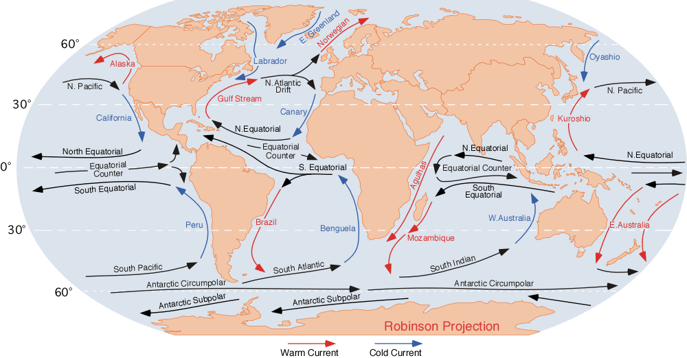
English: the ocean currents.
Note that
Finally, a few gyres also exist at the poles (not shown at this map); these are:
|
| Tarix | |
| Mənbə | http://blue.utb.edu/paullgj/geog3333/lectures/physgeog.html, original image |
| Müəllif | Dr. Michael Pidwirny (see http://www.physicalgeography.net) |
| İcazə (Faylın təkrar istifadəsi) |
Public domain. U.S. government publication. |
Lisenziya
This work is in the public domain in the United States because it is a work prepared by an officer or employee of the United States Federal Government as part of that person’s official duties under the terms of Title 17, Chapter 1, Section 105 of the US Code.
Note: This only applies to original works of the Federal Government and not to the work of any individual U.S. state, territory, commonwealth, county, municipality, or any other subdivision. This template also does not apply to postage stamp designs published by the United States Postal Service since 1978. (See § 313.6(C)(1) of Compendium of U.S. Copyright Office Practices). It also does not apply to certain US coins; see The US Mint Terms of Use.
|
||
| Bu fayl bütün əlaqəli və qonşu hüquqlar da daxil olmaqla, müəllif hüquqları qanununa əsasən məlum məhdudiyyətlərdən azad olduğu müəyyən edilmişdir. | ||
Orijinal yükləmə gündəliyi
| Tarix/Vaxt | Ölçülər | İstifadəçi | Şərh |
|---|---|---|---|
| 10 avqust 2007, 06:43:09 | 1000 × 522 (70712 bytes) | L30nc1t0 (müzakirə · töhfələr) | {{Information |Description=Imagen de las corrientes oceánicas mundiales. |Source=http://blue.utb.edu/paullgj/geog3333/lectures/physgeog.html |Date=Desconocido |Author=Desconocido |Permission=Desconocido. Entidad pública gubernamental estadounidense. |ot |
Faylın tarixçəsi
Faylın əvvəlki versiyasını görmək üçün gün/tarix bölməsindəki tarixlərə klikləyin.
| Tarix/Vaxt | Miniatür | Ölçülər | İstifadəçi | Şərh | |
|---|---|---|---|---|---|
| hal-hazırkı | 10:18, 3 dekabr 2014 | | 1.000 × 522 (75 KB) | GifTagger | Bot: Converting file to superior PNG file. (Source: Corrientes-oceanicas.gif). This GIF was problematic due to non-greyscale color table. |
Faylın istifadəsi
Aşağıdakı 7 səhifə bu faylı istifadə edir:
Faylın qlobal istifadəsi
Bu fayl aşağıdakı vikilərdə istifadə olunur:
- af.wikipedia.org layihəsində istifadəsi
- ar.wikipedia.org layihəsində istifadəsi
- ast.wikipedia.org layihəsində istifadəsi
- be.wikipedia.org layihəsində istifadəsi
- bg.wikipedia.org layihəsində istifadəsi
- bh.wikipedia.org layihəsində istifadəsi
- ca.wikipedia.org layihəsində istifadəsi
- ce.wikipedia.org layihəsində istifadəsi
- cv.wikipedia.org layihəsində istifadəsi
- da.wikipedia.org layihəsində istifadəsi
- de.wikipedia.org layihəsində istifadəsi
- el.wikipedia.org layihəsində istifadəsi
- en.wikipedia.org layihəsində istifadəsi
- Sailing
- Ocean current
- Sea lane
- Cape Horn Current
- South Atlantic Current
- Subantarctic
- Lomonosov Current
- Sea
- Ocean
- Wikipedia:Reference desk/Archives/Science/2013 April 24
- Wikipedia:Reference desk/Archives/Science/2017 November 27
- Wikipedia:Reference desk/Archives/Science/2019 July 30
- File talk:Corrientes-oceanicas.png
- en.wikibooks.org layihəsində istifadəsi
- eo.wikipedia.org layihəsində istifadəsi
- es.wikipedia.org layihəsində istifadəsi
Bu faylın qlobal istifadəsinə baxın.