Butun axtardiqlarinizi tapmaq ucun buraya: DAXIL OLUN
  Mp4 Mp3 Axtar Yukle
  Video Axtar Yukle
  Shekil Axtar Yukle
  Informasiya Melumat Axtar
  Hazir Inshalar Toplusu
  AZERI CHAT + Tanishliq
  1-11 Sinif Derslikler Yukle
  Saglamliq Tibbi Melumat
  Whatsapp Plus Yukle(Yeni)

  • Ana səhifə
  • Təsadüfi
  • Yaxınlıqdakılar
  • Daxil ol
  • Nizamlamalar
İndi ianə et Əgər Vikipediya sizin üçün faydalıdırsa, bu gün ianə edin.

Fayl:Colonisation 1800.png

  • Fayl
  • Müzakirə
  • Vikianbar üzərindən baxış
  • Lokal izah əlavə et
  • Fayl
  • Faylın tarixçəsi
  • Faylın istifadəsi
  • Faylın qlobal istifadəsi
  • Metaməlumatlar
Fayl:Colonisation 1800.png
Sınaq göstərişi ölçüsü: 800 × 351 piksel. Digər ölçülər: 320 × 140 piksel | 640 × 281 piksel | 1.425 × 625 piksel.
Faylın orijinalı (1.425 × 625 piksel, fayl həcmi: 42 KB, MIME növü: image/png)
Bu fayl Vikianbarda yerləşir. Açıqlama səhifəsindəki məlumatlar aşağıda göstərilib.
Vikianbar azad lisenziyalı media anbarıdır. Siz də töhfə verə bilərsiniz.

Xülasə

İzahColonisation 1800.png
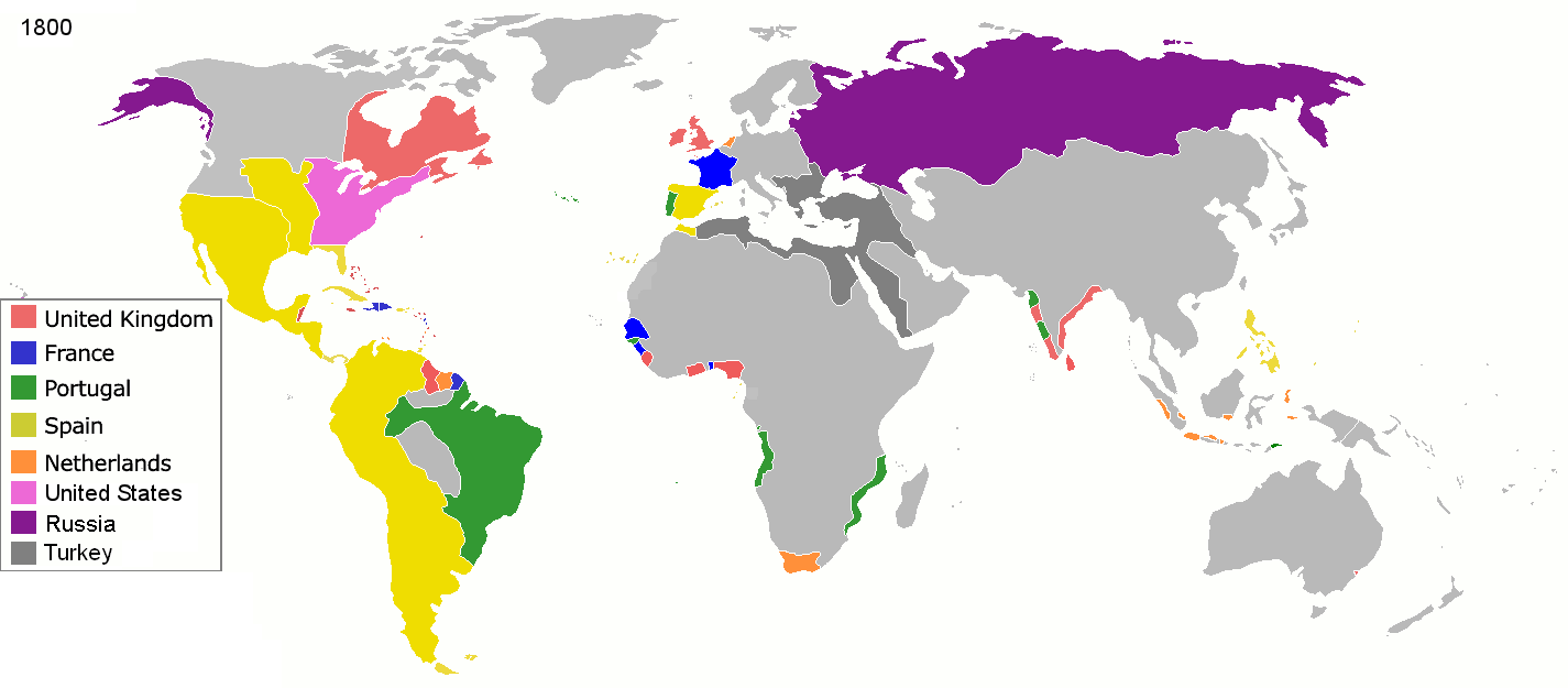
English: Colonial empires in 1800
Français : Empires coloniaux en 1800
Español: Imperios coloniales en 1800
Português: Impérios Coloniais em 1800
 
United Kingdom
 
France
 
Portugal
 
Spain
 
Netherlands
 
United States
 
Russia
 
Turkey
Maps of world history
BC

5000 · 2000 · 1000 · 500 · 400 · 323 · 300 · 200 · 100 · 50


AD

1 · 50 · 100 · 200 · 250 · 300 · 400 · 500 · 700 · 750 · 820 · 900 · 1200 · 1500 · 1556 · 1648 · 1700 · 1750 · 1815 · 1859 · 1871 · 1914 · 1935 · 1954 · 1989 · 2000 ·


Maps of colonization history
1492 · 1550 · 1600 · 1660 · 1754 · 1800 · 1812 · 1822 · 1885 · 1898 · 1914 · 1920 · 1936 · 1938 · 1945 · 1959 · 1974 · 1975 · 2007
Animated Map

Maps of Cold War
1959 · 1980 · Nows ·

see also: Eastern Hemisphere only maps template (1300BC-1500AD)

(this template: · view · discuss )
Tarix 1 mart 2008
Mənbə Öz işi
Müəllif Jluisrs
İcazə
(Faylın təkrar istifadəsi)
Public domainPublic domainfalsefalse
Public domain Mən, bu əsərin müəllif hüquqlarının sahibi kimi, əsəri ictimai mülkiyyətə buraxıram. Bu icazə bütün dünyada qüvvədədir.
In some countries this may not be legally possible; if so:
Mən hər kəsə bu əsərdən hər hansı bir məqsəd üçün, heç bir şərt olmadan, qanunla belə şərtlər tələb olunmadığı təqdirdə istifadə etmək hüququnu verirəm.
File:Colonial empires in 1800.svg is a vector version of this file. It should be used in place of this PNG file when not inferior.

File:Colonisation 1800.png → File:Colonial empires in 1800.svg

For more information, see Help:SVG.

In other languages
Alemannisch ∙ العربية ∙ беларуская (тарашкевіца) ∙ български ∙ বাংলা ∙ català ∙ нохчийн ∙ čeština ∙ dansk ∙ Deutsch ∙ Ελληνικά ∙ English ∙ British English ∙ Esperanto ∙ español ∙ eesti ∙ euskara ∙ فارسی ∙ suomi ∙ français ∙ Frysk ∙ galego ∙ Alemannisch ∙ עברית ∙ हिन्दी ∙ hrvatski ∙ magyar ∙ հայերեն ∙ Bahasa Indonesia ∙ Ido ∙ italiano ∙ 日本語 ∙ ქართული ∙ 한국어 ∙ lietuvių ∙ македонски ∙ മലയാളം ∙ Bahasa Melayu ∙ မြန်မာဘာသာ ∙ norsk bokmål ∙ Plattdüütsch ∙ Nederlands ∙ norsk nynorsk ∙ norsk ∙ occitan ∙ polski ∙ prūsiskan ∙ português ∙ português do Brasil ∙ română ∙ русский ∙ sicilianu ∙ Scots ∙ slovenčina ∙ slovenščina ∙ српски / srpski ∙ svenska ∙ தமிழ் ∙ ไทย ∙ Türkçe ∙ татарча / tatarça ∙ українська ∙ vèneto ∙ Tiếng Việt ∙ 中文 ∙ 中文(中国大陆) ∙ 中文(简体) ∙ 中文(繁體) ∙ 中文(马来西亚) ∙ 中文(新加坡) ∙ 中文(臺灣) ∙ +/−
New SVG image


Annotations
InfoField
This image is annotated: View the annotations at Commons
1261
511
80
75
1425
625

The extent of British influence in New Zealand in 1800 was the existence of whaling ships and flax traders. Americans and French were also present in New Zealand waters. Missionary presence had not even been established yet, and gun traders weren't significant until about the time of the Musket Wars. New Zealand not British prior to 1840 annexation. However, under the 1788 amended charter of the New South Wales colony, islands adjacent to that region of Australia within the bounds of 10°37'S and 43°39'S are included under it. This includes all but the Southern half of South Island. Recognizing this might be like recognizing the Treaty of Tordesillas on this map, but there is some basis for most of New Zealand being counted as a British colony on this map. (See: http://en.wikipedia.org/wiki/History_of_new_zealand#British_sovereignty, http://en.wikipedia.org/wiki/43rd_parallel_south) Nanib (talk) 19:08, 8 September 2011 (UTC)

322
479
121
142
1425
625

Araucania and Patagonia not colonized or occupied by Europeans. Mapuche groups prevented Southward expansion by Spanish. Chile and Argentina began occupying the region from 1843-1902. http://en.wikipedia.org/wiki/Patagonia#Chilean_and_Argentine_expansion_.281843-1902.29

468
48
96
73
1425
625

A Norwegian colony existed at Nuuk from 1728. It became Danish in 1814. http://en.wikipedia.org/wiki/Nuuk

778
335
68
82
1425
625

Omanese colonies on East African coast from 1698. It might be good to include this, but if the focus of this map is European-related colonies, then it shouldn't be. http://en.wikipedia.org/wiki/Oman#Oman_and_East_Africa

965
242
48
45
1425
625

British may have had further holdings in Bengal. http://en.wikipedia.org/wiki/Company_rule_in_India#Expansion_and_territory

800
297
41
32
1425
625

Zeila, in Western Somililand, ruled by Ottomans from 1548. http://en.wikipedia.org/wiki/History_of_Somaliland#Ottoman_Somaliland

615
329
27
25
1425
625

Dutch Gold Coast from 1598. It might be too small to show. http://en.wikipedia.org/wiki/Dutch_Gold_Coast

1167
281
155
64
1425
625

The Spanish East Indies in the Pacific. After its discovery in 1521, all of Micronesia was included in the Captaincy General of the Philippines of Spain, but his claim effectively began in 1885, the year in which the Micronesia partitioned between Spain and Germany.

729
214
69
69
1425
625

In 1800 the French occupation lasted (http://en.wikipedia.org/wiki/French_campaign_in_Egypt_and_Syria)

Başlıqlar

Bu faylın nəyi təmsil etdiyinə dair bir sətirlik izahat əlavə et
Колониальные империи в 1800 году

Bu faylda təsvir olunan elementlər

təsvir edir

yaradıcı

Vikidata elementi olmayan bir neçə dəyər

Vikimedia istifadəçi adı: Jluisrs
URL: /wiki/user:Jluisrs
müəllifin qısa adı: Jluisrs

copyright status ingilis

müəllif hüquqları ilə qorunur, lakin müəllif hüquqlarının sahibi tərəfindən ictimai istifadəyə verilmişdir

lisenziya

released into the public domain by the copyright holder ingilis

yaranma tarixi

1 mart 2008

source of file ingilis

original creation by uploader ingilis

media type ingilis

image/png

checksum ingilis

1c447d15b6569cd35e35abf1b38379514daaa313

təyinetmə üsulu: SHA-1

data size ingilis

42.860 Bayt

hündürlüyü/boyu

625 piksel

eni

1.425 piksel

Faylın tarixçəsi

Faylın əvvəlki versiyasını görmək üçün gün/tarix bölməsindəki tarixlərə klikləyin.

(ən yeni | ən əvvəlki) Göstər (10 daha yeni | 10 daha köhnə) (10 | 20 | 50 | 100 | 250 | 500).
Tarix/VaxtMiniatürÖlçülərİstifadəçiŞərh
hal-hazırkı19:28, 1 may 201619:28, 1 may 2016 tarixindəki versiyanın miniatür görüntüsü1.425 × 625 (42 KB)Mega-lightDominican Republic was a French colonia between 1795 and 1808 through Treaty of Basilea.
19:21, 1 may 201619:21, 1 may 2016 tarixindəki versiyanın miniatür görüntüsü1.425 × 625 (42 KB)Mega-lightDominican Republic was a French colonia between 1795 and 1808.
23:55, 27 sentyabr 201423:55, 27 sentyabr 2014 tarixindəki versiyanın miniatür görüntüsü1.425 × 625 (42 KB)Leftcryminor
05:48, 16 may 201305:48, 16 may 2013 tarixindəki versiyanın miniatür görüntüsü1.425 × 625 (40 KB)Kraj35British settlement in Australia - Sydney and Parramatta.
03:30, 16 yanvar 201203:30, 16 yanvar 2012 tarixindəki versiyanın miniatür görüntüsü1.425 × 625 (52 KB)Quigleycleaner legend
14:07, 29 aprel 201014:07, 29 aprel 2010 tarixindəki versiyanın miniatür görüntüsü1.425 × 625 (49 KB)Kieran4Border changes
14:06, 29 aprel 201014:06, 29 aprel 2010 tarixindəki versiyanın miniatür görüntüsü1.425 × 625 (49 KB)Kieran4Dutch claims in Indonesia were exaggerated and Cape Colony was too small.
16:50, 15 fevral 200916:50, 15 fevral 2009 tarixindəki versiyanın miniatür görüntüsü1.425 × 625 (49 KB)EuroHistoryTeacherlousiana was spanish in 1800, would be french officially in 1803 then sold to USA. no spanish settlement in western sahara, or spanish guinea. USA was not a colonisation power.
20:38, 21 yanvar 200920:38, 21 yanvar 2009 tarixindəki versiyanın miniatür görüntüsü1.425 × 625 (49 KB)TashkentFox{{Information |Description= |Source= |Date= |Author= |Permission= |other_versions= }}
(ən yeni | ən əvvəlki) Göstər (10 daha yeni | 10 daha köhnə) (10 | 20 | 50 | 100 | 250 | 500).

Faylın istifadəsi

Aşağıdakı səhifə bu faylı istifadə edir:

  • Kolonializm

Faylın qlobal istifadəsi

Bu fayl aşağıdakı vikilərdə istifadə olunur:

  • af.wikipedia.org layihəsində istifadəsi
    • Imperialisme
  • ast.wikipedia.org layihəsində istifadəsi
    • Década del 1790
    • Sieglu XVIII
    • Virreinatu de Nueva España
  • ba.wikipedia.org layihəsində istifadəsi
    • Империализм
  • be.wikipedia.org layihəsində istifadəsi
    • Іспанская імперыя
  • bs.wikipedia.org layihəsində istifadəsi
    • Imperijalizam
  • ca.wikipedia.org layihəsində istifadəsi
    • Colonialisme
    • Viquiprojecte:Colonialisme
    • Tema:Uepakudoa142kpom
  • ce.wikipedia.org layihəsində istifadəsi
    • Империализм
  • cs.wikipedia.org layihəsində istifadəsi
    • Kolonie
  • da.wikipedia.org layihəsində istifadəsi
    • Imperialisme
    • Kolonialisme
  • en.wikipedia.org layihəsində istifadəsi
    • Imperialism
    • List of national border changes (1815–1914)
    • Wikipedia:Graphics Lab/Image workshop/Archive/Nov 2008
    • Talk:Spain/Archive 7
    • User:Benisajew/sandbox
  • eo.wikipedia.org layihəsində istifadəsi
    • Imperiismo
    • Koloniismo
  • es.wikipedia.org layihəsində istifadəsi
    • Años 1800
    • Años 1790
    • Occidente
    • Imperialismo
    • Usuario:SPQRes/Temporal
    • Cristiandad occidental
    • Expansión europea
  • eu.wikipedia.org layihəsində istifadəsi
    • Inperialismo
    • Txikipedia:Inperialismo
  • fi.wikipedia.org layihəsində istifadəsi
    • Siirtomaa
  • fr.wikipedia.org layihəsində istifadəsi
    • Années 1800
    • Colonialisme
    • Société occidentale
    • Culture de l'Europe
  • gl.wikipedia.org layihəsində istifadəsi
    • Colonialismo
    • Imperialismo
    • Vicerreinado de Nova España
  • ha.wikipedia.org layihəsində istifadəsi
    • Imperialism
  • he.wikipedia.org layihəsində istifadəsi
    • העשור הראשון של המאה ה-19
  • hy.wikipedia.org layihəsində istifadəsi
    • Իսպանական կայսրություն
  • id.wikipedia.org layihəsində istifadəsi
    • Imperium kolonial
  • io.wikipedia.org layihəsində istifadəsi
    • Yari 1800a
  • it.wikipedia.org layihəsində istifadəsi
    • Colonialismo
  • ja.wikipedia.org layihəsində istifadəsi
    • 植民地
    • 植民地主義
  • ka.wikipedia.org layihəsində istifadəsi
    • კოლონიალიზმი
  • meta.wikimedia.org layihəsində istifadəsi
    • Grants:APG/Proposals/2017-2018 round 1/Amical Wikimedia/Progress report form
    • Grants:APG/Proposals/2017-2018 round 1/Amical Wikimedia/Impact report form
  • ml.wikipedia.org layihəsində istifadəsi
    • കോളനിവാഴ്ച

Bu faylın qlobal istifadəsinə baxın.

Metaməlumatlar

Bu faylda fotoaparat və ya skanerlə əlavə olunmuş məlumatlar var. Əgər fayl sonradan olunubsa, bəzi parametrlər bu şəkildə göstərilənlərdən fərqli ola bilər.

Üfüqi xətt37,8 dpc
Şaquli xətt37,8 dpc
Mənbə — "https://az.wikipedia.org/wiki/Fayl:Colonisation_1800.png"
Informasiya Melumat Axtar