Sınaq göstərişi ölçüsü: 599 × 599 piksel. Digər ölçülər: 240 × 240 piksel | 480 × 480 piksel | 768 × 768 piksel | 1.023 × 1.024 piksel | 1.631 × 1.632 piksel.
Faylın orijinalı (1.631 × 1.632 piksel, fayl həcmi: 365 KB, MIME növü: image/jpeg)
Bu fayl Vikianbarda yerləşir. Açıqlama səhifəsindəki məlumatlar aşağıda göstərilib. Vikianbar azad lisenziyalı media anbarıdır. Siz də töhfə verə bilərsiniz. |
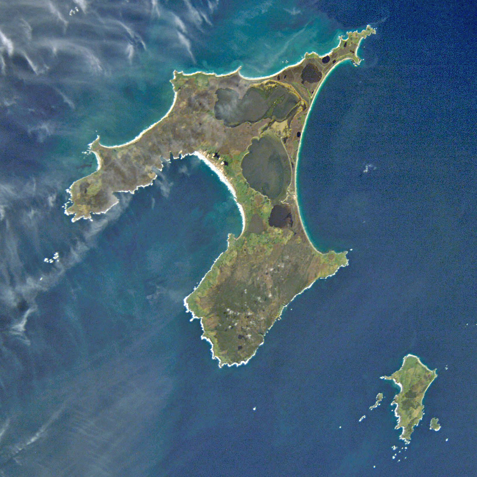
== Xülasə ==NASA GOV
| İzah |
English: NASA astronaut image of Chatham Islands, New Zealand, in the Pacific Ocean. North is up.
Deutsch: NASA-Astronautenbild der Chatham-Inseln, Neuseeland, im Pazifischen Ozean
Français : Image satellite de la NASA montrant les îles Chatham, dans l'océan Pacifique. Orientée nord.
|
||||||||||||||||||||||||||||||||||||||||||||||||||
| Tarix | |||||||||||||||||||||||||||||||||||||||||||||||||||
| Mənbə | http://eol.jsc.nasa.gov/scripts/sseop/QuickView.pl?directory=ESC&ID=ISS005-E-15265 | ||||||||||||||||||||||||||||||||||||||||||||||||||
| Müəllif | NASA | ||||||||||||||||||||||||||||||||||||||||||||||||||
| İcazə (Faylın təkrar istifadəsi) |
Conditions of Use of Astronaut Photographs | ||||||||||||||||||||||||||||||||||||||||||||||||||
| Camera location | | View this and other nearby images on: OpenStreetMap |
|---|
This image or video was catalogued by Johnson Space Center of the United States National Aeronautics and Space Administration (NASA) under Photo ID: ISS005-E-15265. This tag does not indicate the copyright status of the attached work. A normal copyright tag is still required. See Commons:Licensing. Other languages:
|
| Bu təsvirin si, orijinala əsaslanaraq rəqəmsal qaydadadır. Dəyişiklik: cropped.
|
Lisenziya
This file is in the public domain in the United States because it was created by the Image Science & Analysis Laboratory, of the NASA Johnson Space Center. NASA copyright policy states that "NASA material is not protected by copyright unless noted". (NASA media use guidelines or Conditions of Use of Astronaut Photographs).
Photo source: ISS005-E-15265.
|

|
This image has been assessed under the valued image criteria and is considered the most valued image on Commons within the scope: Satellite picture of the Chatham Islands. You can see its nomination here. |
Faylın tarixçəsi
Faylın əvvəlki versiyasını görmək üçün gün/tarix bölməsindəki tarixlərə klikləyin.
| Tarix/Vaxt | Miniatür | Ölçülər | İstifadəçi | Şərh | |
|---|---|---|---|---|---|
| hal-hazırkı | 20:02, 13 aprel 2011 | | 1.631 × 1.632 (365 KB) | Alexrk2 | digitally enhanced |
| 04:46, 17 sentyabr 2005 |  | 1.631 × 1.632 (269 KB) | Zeimusu | Chatham Islands, photo taken by Astronaut aboard the ISS Based on Public Domain image from Nasa. Earth Sciences and Image Analysis, NASA-Johnson Space Center. 24 Sep. 2003. "Astronaut Photography of Earth - Quick View." http://eol.jsc.nasa.gov/scripts/s |
Faylın istifadəsi
Aşağıdakı səhifə bu faylı istifadə edir:
Faylın qlobal istifadəsi
Bu fayl aşağıdakı vikilərdə istifadə olunur:
- af.wikipedia.org layihəsində istifadəsi
- ar.wikipedia.org layihəsində istifadəsi
- be.wikipedia.org layihəsində istifadəsi
- bn.wikipedia.org layihəsində istifadəsi
- br.wikipedia.org layihəsində istifadəsi
- ca.wikipedia.org layihəsində istifadəsi
- ceb.wikipedia.org layihəsində istifadəsi
- cs.wikipedia.org layihəsində istifadəsi
- da.wikipedia.org layihəsində istifadəsi
- de.wikipedia.org layihəsində istifadəsi
- de.wiktionary.org layihəsində istifadəsi
- el.wikipedia.org layihəsində istifadəsi
- en.wikipedia.org layihəsində istifadəsi
- en.wikivoyage.org layihəsində istifadəsi
- eo.wikipedia.org layihəsində istifadəsi
- es.wikipedia.org layihəsində istifadəsi
- et.wikipedia.org layihəsində istifadəsi
- fa.wikipedia.org layihəsində istifadəsi
- frr.wikipedia.org layihəsində istifadəsi
- fr.wikipedia.org layihəsində istifadəsi
- fr.wiktionary.org layihəsində istifadəsi
- fy.wikipedia.org layihəsində istifadəsi
- gl.wikipedia.org layihəsində istifadəsi
Bu faylın qlobal istifadəsinə baxın.