Butun axtardiqlarinizi tapmaq ucun buraya: DAXIL OLUN
  Mp4 Mp3 Axtar Yukle
  Video Axtar Yukle
  Shekil Axtar Yukle
  Informasiya Melumat Axtar
  Hazir Inshalar Toplusu
  AZERI CHAT + Tanishliq
  1-11 Sinif Derslikler Yukle
  Saglamliq Tibbi Melumat
  Whatsapp Plus Yukle(Yeni)

  • Ana səhifə
  • Təsadüfi
  • Yaxınlıqdakılar
  • Daxil ol
  • Nizamlamalar
İndi ianə et Əgər Vikipediya sizin üçün faydalıdırsa, bu gün ianə edin.

Fayl:Cat Island, Bahamas.JPG

  • Fayl
  • Müzakirə
  • Lokal izah əlavə et
  • Fayl
  • Faylın tarixçəsi
  • Faylın istifadəsi
  • Faylın qlobal istifadəsi
  • Metaməlumatlar
Fayl:Cat Island, Bahamas.JPG
Sınaq göstərişi ölçüsü: 800 × 532 piksel. Digər ölçülər: 320 × 213 piksel | 640 × 426 piksel | 1.024 × 681 piksel | 1.280 × 852 piksel | 2.560 × 1.703 piksel | 4.256 × 2.832 piksel.

Faylın orijinalı (4.256 × 2.832 piksel, fayl həcmi: 6,61 MB, MIME növü: image/jpeg)

Bu fayl Vikianbarda yerləşir. Açıqlama səhifəsindəki məlumatlar aşağıda göstərilib.
Vikianbar azad lisenziyalı media anbarıdır. Siz də töhfə verə bilərsiniz.

Xülasə

İzahCat Island, Bahamas.JPG
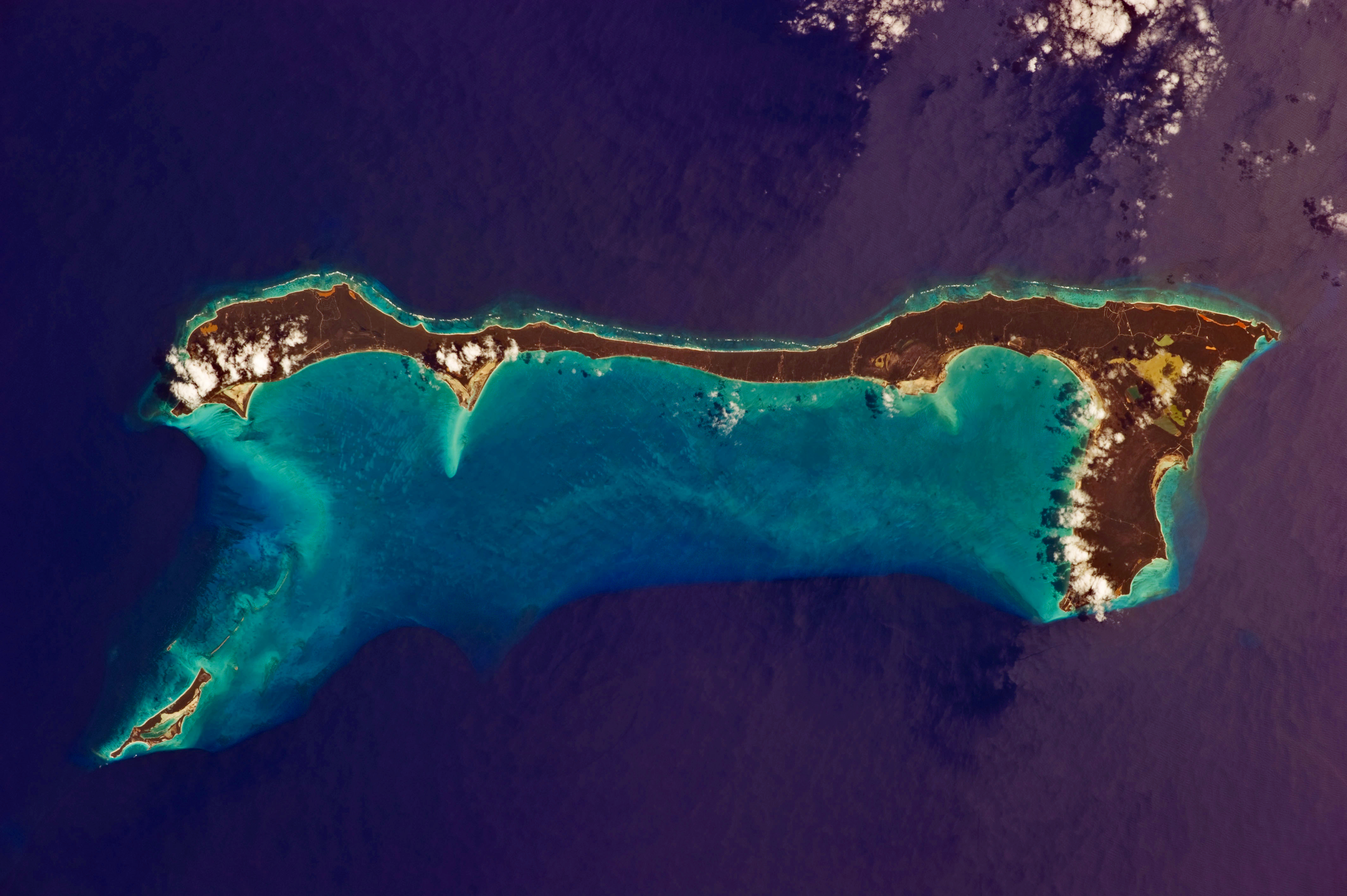
English: Like most other islands in the Bahamas, Cat Island is located on a large depositional platform that is composed mainly of carbonate sediments and surrounding reefs. The approximately 77 kilometre-long island is the part of the platform continuously exposed above water, which allows for soil development (brown to tan areas) and the growth of vegetation. Shallow water to the west-south-west (below the island in this view) appears bright blue, in contrast to the deeper ocean waters to the north, east, and south. In this astronaut photograph, the ocean surface near the south-eastern half of the island has a slight grey tinge due to sun-glint, or light reflecting off the water surface back towards the International Space Station. Small white cumulus clouds obscure some parts of the island.
Tarix 10 mart 2011
Mənbə NASA Earth Observatory
Müəllif ISS Expedition 26 crew
Camera location24° 24′ 00″ N, 75° 36′ 00″ W Kartographer map based on OpenStreetMap.View this and other nearby images on: OpenStreetMapinfo 24.400000; -75.600000
This image or video was catalogued by Johnson Space Center of the United States National Aeronautics and Space Administration (NASA) under Photo ID: ISS026-E-33193.

This tag does not indicate the copyright status of the attached work. A normal copyright tag is still required. See Commons:Licensing.
Other languages:

Afrikaans ∙ العربية ∙ беларуская (тарашкевіца) ∙ български ∙ Bahaso Jambi ∙ català ∙ čeština ∙ dansk ∙ Deutsch ∙ English ∙ español ∙ فارسی ∙ français ∙ galego ∙ magyar ∙ հայերեն ∙ Bahasa Indonesia ∙ italiano ∙ 日本語 ∙ македонски ∙ മലയാളം ∙ Nederlands ∙ polski ∙ português ∙ русский ∙ sicilianu ∙ slovenščina ∙ Türkçe ∙ українська ∙ 简体中文 ∙ 繁體中文 ∙ +/−

Image acquired with a Nikon D3S digital camera using an effective 135 mm lens, and is provided by the ISS Crew Earth Observations experiment and Image Science & Analysis Laboratory, Johnson Space Center.

Lisenziya

Public domainPublic domainfalsefalse
Public domain This file is in the public domain in the United States because it was solely created by NASA. NASA copyright policy states that "NASA material is not protected by copyright unless noted". (See Template:PD-USGov, NASA copyright policy page or JPL Image Use Policy.)
Warnings:
  • Use of NASA logos, insignia and emblems is restricted per U.S. law 14 CFR 1221.
  • The NASA website hosts a large number of images from the Soviet/Russian space agency, and other non-American space agencies. These are not necessarily in the public domain.
  • Materials based on Hubble Space Telescope data may be copyrighted if they are not explicitly produced by the STScI.[1] See also {{PD-Hubble}} and {{Cc-Hubble}}.
  • The SOHO (ESA & NASA) joint project implies that all materials created by its probe are copyrighted and require permission for commercial non-educational use. [2]
  • Images featured on the Astronomy Picture of the Day (APOD) web site may be copyrighted. [3]
  • The National Space Science Data Center (NSSDC) site has been known to host copyrighted content. Its photo gallery FAQ states that all of the images in the photo gallery are in the public domain "Unless otherwise noted."
Annotations
InfoField
This image is annotated: View the annotations at Commons
69
90
931
437
4256
2832

Atlantic Ocean

1005
1070
59
53
4256
2832

Arthur's Town

3016
1054
43
43
4256
2832

Mount Alvernia

314
2076
436
383
4256
2832

Little San Salvador Island

Başlıqlar

Bu faylın nəyi təmsil etdiyinə dair bir sətirlik izahat əlavə et

Bu faylda təsvir olunan elementlər

təsvir edir

əhəmiyyətli hadisə

Expedition 26 ingilis

copyright status ingilis

ictimai mülkiyyət

təyinetmə üsulu: work of the federal government of the United States ingilis

yaranma tarixi

10 mart 2011

coordinates of the point of view ingilis

24°24'0.000"N, 75°36'0.000"W

captured with ingilis

Nikon D3S ingilis

kataloq kodu

ISS026-E-33193

kataloq: Media catalogue of the Johnson Space Center ingilis

media type ingilis

image/jpeg

checksum ingilis

a9a07a0a67e728e4b279b83655dcf3cb43be9433

təyinetmə üsulu: SHA-1

data size ingilis

6.927.574 Bayt

hündürlüyü/boyu

2.832 piksel

eni

4.256 piksel

exposure time ingilis

0,002 saniyə

f-number ingilis

8

ISO speed ingilis

200

anlayışın sinfi

fotoqrafiya

focal length ingilis

135 millimetr

Faylın tarixçəsi

Faylın əvvəlki versiyasını görmək üçün gün/tarix bölməsindəki tarixlərə klikləyin.

Tarix/VaxtMiniatürÖlçülərİstifadəçiŞərh
hal-hazırkı10:37, 21 mart 201110:37, 21 mart 2011 tarixindəki versiyanın miniatür görüntüsü4.256 × 2.832 (6,61 MB)Originalwana{{Information |Description ={{en|1=Like most other islands in the Bahamas, Cat Island is located on a large depositional platform that is composed mainly of carbonate sediments and surrounding reefs. The approximately 77 kilometre-long island is the pa

Faylın istifadəsi

Aşağıdakı səhifə bu faylı istifadə edir:

  • Ket-Aylend (Baham adaları)

Faylın qlobal istifadəsi

Bu fayl aşağıdakı vikilərdə istifadə olunur:

  • ar.wikipedia.org layihəsində istifadəsi
    • جزيرة كات
  • arz.wikipedia.org layihəsində istifadəsi
    • جزيره كات
  • ca.wikipedia.org layihəsində istifadəsi
    • Illa Cat
  • ceb.wikipedia.org layihəsində istifadəsi
    • Cat Island (distrito)
  • cs.wikipedia.org layihəsində istifadəsi
    • Cat Island
  • de.wikipedia.org layihəsində istifadəsi
    • Cat Island (Bahamas)
  • de.wikivoyage.org layihəsində istifadəsi
    • Bahamas
  • el.wikipedia.org layihəsində istifadəsi
    • Κατ Άιλαντ
  • en.wikipedia.org layihəsində istifadəsi
    • Cat Island, The Bahamas
  • es.wikipedia.org layihəsində istifadəsi
    • Isla Cat
  • fi.wikipedia.org layihəsində istifadəsi
    • Cat Island
  • fr.wikipedia.org layihəsində istifadəsi
    • Cat Island (Bahamas)
  • gl.wikipedia.org layihəsində istifadəsi
    • Cat Island
  • he.wikipedia.org layihəsində istifadəsi
    • משטח קרבונטי
    • משתמש:WikiJunkie/רשימות שימושיות שמופקות באמצעות הבוט ליסטריה/איים - כל הערכים שחסרים
  • it.wikipedia.org layihəsində istifadəsi
    • Cat (isola)
  • ko.wikipedia.org layihəsində istifadəsi
    • 캣섬
  • lt.wikipedia.org layihəsində istifadəsi
    • Kato sala
  • nl.wikipedia.org layihəsində istifadəsi
    • Cat Island
  • no.wikipedia.org layihəsində istifadəsi
    • Cat Island (Bahamas)
  • pl.wikipedia.org layihəsində istifadəsi
    • Cat Island
  • pt.wikipedia.org layihəsində istifadəsi
    • Ilha Cat
  • ro.wikipedia.org layihəsində istifadəsi
    • Insula Cat
  • www.wikidata.org layihəsində istifadəsi
    • Q1050154
  • zh.wikipedia.org layihəsində istifadəsi
    • 卡特島

Metaməlumatlar

Bu faylda fotoaparat və ya skanerlə əlavə olunmuş məlumatlar var. Əgər fayl sonradan olunubsa, bəzi parametrlər bu şəkildə göstərilənlərdən fərqli ola bilər.

Kamera istehsalçısıNIKON CORPORATION
Kamera modeliNIKON D3S
Exposure time1/500 saniyə (0,002)
F nömrəsif/8
ISO sürət reytinqi200
Orijinal tarix və vaxt15:41, 10 mart 2011
Fokus məsafəsi135 mm
OrientasiyaNormal
Üfüqi xətt300 dpi
Şaquli xətt300 dpi
Proqram təminatıMicrosoft Windows Photo Gallery 6.0.6001.18000
Faylın dəyişməsi tarixi və vaxtı10:29, 21 mart 2011
Ekspozisiya proqramıShutter priority
Exif versiyası2.21
Tarix və vaxt rəqəmləşdirilir15:41, 10 mart 2011
APEX shutter speed8,965784
Obyektiv gözü6
APEX exposure bias0
Maximum land aperture3 APEX (f/2,83)
Metering modeCenter weighted average
İşıq mənbəsiNaməlum
FlaşFlaş yandırılmadı
DateTime subseconds68
DateTimeOriginal subseconds68
DateTimeDigitized subseconds68
Rəng sahəsisRGB
Sensing methodBirkristallı matrisli rəngli sensor
Custom image processingNormal proses
Exposure modeAvtomatik ekspozisiya
Ağ balansıBəyaz balansın avtomatik tənzimlənməsi
Digital zoom ratio1
Focal length in 35 mm film135 mm
Scene capture typeStandart
KontrastNormal
DoymuşluqNormal
KəskinlikNormal
Subject distance rangeNaməlum
Mənbə — "https://az.wikipedia.org/wiki/Fayl:Cat_Island,_Bahamas.JPG"
Informasiya Melumat Axtar