Sınaq göstərişi ölçüsü: 471 × 599 piksel. Digər ölçülər: 188 × 240 piksel | 377 × 480 piksel | 603 × 768 piksel | 804 × 1.024 piksel | 1.609 × 2.048 piksel | 4.400 × 5.600 piksel.
Faylın orijinalı (4.400 × 5.600 piksel, fayl həcmi: 9,04 MB, MIME növü: image/jpeg)
Bu fayl Vikianbarda yerləşir. Açıqlama səhifəsindəki məlumatlar aşağıda göstərilib. Vikianbar azad lisenziyalı media anbarıdır. Siz də töhfə verə bilərsiniz. |
|
| İzah |
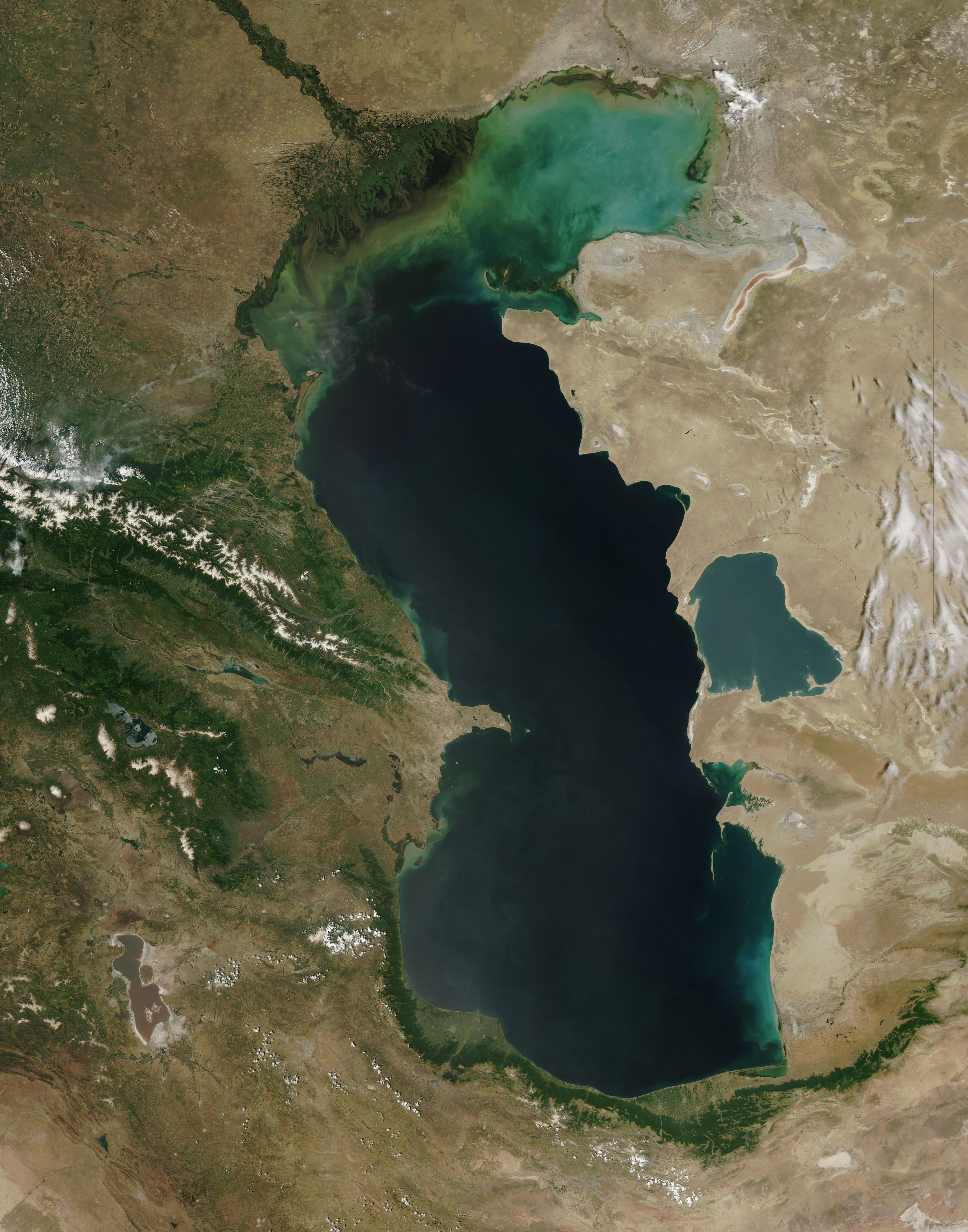
Español: El Mar Caspio visto desde la órbita terrestre English: This is a view from orbit of the Caspian Sea as imaged by the MODIS sensor on the Terra satellite. Caption: The original caption from NASA: ::"The northern part of the Caspian Sea is plagued by a process called eutrophication, in which agricultural run-off rich in fertilizers stimulates rampant growth of algae in the water. The death and decay of these algae robs the water of oxygen, with obvious negative consequences for aquatic life. This image of the Caspian Sea shows swirls of green and blue near the mouth of the Volga River (top center), which indicate the presence of algae. The bright blue color of the northeastern part of the sea may be due to a mixture of plant life and sediment, for this is where the sea is most shallow. This image is from the Moderate Resolution Imaging Spectroradiometer (MODIS) on the Terra satellite on June 11, 2003. |
| Tarix | (UTC) |
| Mənbə | |
| Müəllif |
|
| Bu təsvirin si, orijinala əsaslanaraq rəqəmsal qaydadadır. Dəyişiklik: cloned out and healed little all the little red lines. İlkin təsvir buradadır: Caspian Sea from orbit.jpg. etdi IdLoveOne.
|
| This file is in the public domain in the United States because it was solely created by NASA. NASA copyright policy states that "NASA material is not protected by copyright unless noted". (See Template:PD-USGov, NASA copyright policy page or JPL Image Use Policy.) | ||
Warnings:
|
Orijinal yükləmə gündəliyi
This image is a derivative work of the following images:
- File:Caspian_Sea_from_orbit.jpg licensed with PD-USGov-NASA
- 2010-06-14T09:16:01Z Originalwana 4400x5600 (3608474 Bytes) higher res
- 2005-02-08T15:10:25Z Pixeltoo 550x700 (68127 Bytes) Caspian sea by space [[Nasa]]
Uploaded with derivativeFX
Faylın tarixçəsi
Faylın əvvəlki versiyasını görmək üçün gün/tarix bölməsindəki tarixlərə klikləyin.
| Tarix/Vaxt | Miniatür | Ölçülər | İstifadəçi | Şərh | |
|---|---|---|---|---|---|
| hal-hazırkı | 23:51, 2 sentyabr 2010 | | 4.400 × 5.600 (9,04 MB) | IdLoveOne~commonswiki | cloning and healing |
| 16:19, 2 sentyabr 2010 |  | 4.400 × 5.600 (9,04 MB) | IdLoveOne~commonswiki | more cleaning | |
| 16:07, 2 sentyabr 2010 |  | 4.400 × 5.600 (9,04 MB) | IdLoveOne~commonswiki | cleaned more on lower left | |
| 15:46, 2 sentyabr 2010 |  | 4.400 × 5.600 (9,04 MB) | IdLoveOne~commonswiki | {{Information |Description={{es|El '''Mar Caspio''' visto desde la órbita terrestre}} {{en|This is a view from orbit of the Caspian Sea as imaged by the MODIS sensor on the Terra satellite. '''Caption:''' The original caption from NASA: ::"The n |
Faylın istifadəsi
Aşağıdakı səhifə bu faylı istifadə edir:
Faylın qlobal istifadəsi
Bu fayl aşağıdakı vikilərdə istifadə olunur:
- alt.wikipedia.org layihəsində istifadəsi
- ba.wikipedia.org layihəsində istifadəsi
- ca.wikipedia.org layihəsində istifadəsi
- ce.wikipedia.org layihəsində istifadəsi
- Каспий-хӀорд
- Нохчийн гӀайре
- Кеп:Каспий-хӀордан гӀайренаш
- Адсыз ада
- Ӏашур-Ада
- Каспий-хӀордан гӀайренийн могӀам
- Кюр-Даши
- Хиль (гӀайре)
- Игнат даши
- Зенбиль
- ГӀум (гӀайре)
- Бёюк-Зиря
- Чигил
- Сенги-Муган
- Чилов гӀайре
- Яшма (гӀайре)
- Охана йаккхий гӀайренаш
- Джамбайн гӀайре
- Спиркин Осерёдок
- Тюленьи гӀайренаш
- Тюлений (Каспий-хӀорд)
- Верхни Осередок
- Нордови
- Чисти Банка
- Зюдев (гӀайре, Росси)
- Коневски
- Баткачни
- Лихачёв (гӀайре)
- Нижни (гӀайре)
- Мали Сетной
- Большой Сетной
- Мали Зюдостински
- Большой Зюдостински
- Огурджале
- Даш-Зиря
- Хере-Зиря
- Кюр-Дили
- Суатли адалари
- Гутан (гӀайре)
- Даш адалари
- Пираллахи (ахгӀайре)
- Бабурий
- Боьйуьк Тава
- Гарабаттаг (гӀайре)
- Гу (гӀайре)
- Дахили Даш
- Каравансарай (гӀайре)
Bu faylın qlobal istifadəsinə baxın.