
Sınaq göstərişi ölçüsü: 800 × 548 piksel. Digər ölçülər: 320 × 219 piksel | 640 × 439 piksel | 1.024 × 702 piksel | 1.280 × 877 piksel | 1.669 × 1.144 piksel.
Faylın orijinalı (1.669 × 1.144 piksel, fayl həcmi: 151 KB, MIME növü: image/png)
Bu fayl Vikianbarda yerləşir. Açıqlama səhifəsindəki məlumatlar aşağıda göstərilib. Vikianbar azad lisenziyalı media anbarıdır. Siz də töhfə verə bilərsiniz. |
Xülasə
| İzah |
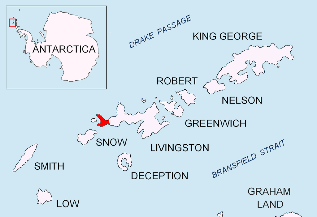
English: Location of Byers Peninsula on Livingston Island in the South Shetland Islands. |
| Tarix | |
| Mənbə | Öz işi |
| Müəllif | Apcbg |
Lisenziya
I, the copyright holder of this work, hereby publish it under the following licenses:
Bu fayl Creative Commons Attribution-Share Alike 3.0 Unported lisenziyası altında yayımlanır.
- Siz heç bir məhdudiyyət olmadan:
- paylaşa bilərsiniz – əsəri köçürə, paylaya və ötürə bilərsiniz
- remiks edə bilərsiniz – əsəri adaptasiya edə bilərsiniz
- Aşağıdakı şərtlərə əməl etməklə:
- istinad vermək – Müvafiq istinad verməli, lisenziyaya keçid əlavə etməli və dəyişikliklər edilib-edilmədiyini bildirməlisiniz . Siz bunu istənilən şəkildə edə bilərsiniz, lakin lisenziya verənin sizə şəxsən icazə verdiyini göstərən formada yox.
- bənzər paylaşma – Əsəri remix edirsinizsə, dəyişdirirsinizsə və ya üzərində iş aparırsınızsa, öz töhfələrinizi orijinalda olduğu kimi eyni və ya uyğun lisenziya altında yayımlamalısınız.

|
Bu sənədi GNU Azad Sənədləşdirmə Lisenziyası, Versiya 1.2 və ya Azad Proqram Fondu tərəfindən nəşr olunan hər hansı sonrakı versiya şərtlərinə əsasən dəyişməz bölmələr, ön qapaq mətnləri və arxa qapaq mətnləri olmadan köçürmək, yayımlamaq və / və ya dəyişdirmək üçün icazə verilir; Lisenziyanın bir nüsxəsi GNU Azad Sənədləşdirmə Lisenziyası adlı hissəyə daxil edilmişdir. |
İstədiyiniz lisenziyanı seçə bilərsiniz.
Faylın tarixçəsi
Faylın əvvəlki versiyasını görmək üçün gün/tarix bölməsindəki tarixlərə klikləyin.
| Tarix/Vaxt | Miniatür | Ölçülər | İstifadəçi | Şərh | |
|---|---|---|---|---|---|
| hal-hazırkı | 16:03, 24 avqust 2010 | | 1.669 × 1.144 (151 KB) | Apcbg | + location in Antarctica |
| 17:28, 1 may 2010 |  | 1.669 × 1.144 (5,47 MB) | Apcbg | {{Information |Description={{en|1=Location of Byers Peninsula on Livingston Island in the South Shetland Islands.}} |Source={{own}} |Author=Apcbg |Date=2010-05-01 |Permission= |other_versions= }} Category:Maps of Antarctica |
Faylın istifadəsi
Aşağıdakı səhifə bu faylı istifadə edir:
Faylın qlobal istifadəsi
Bu fayl aşağıdakı vikilərdə istifadə olunur:
- bg.wikipedia.org layihəsində istifadəsi
- ca.wikipedia.org layihəsində istifadəsi
- ceb.wikipedia.org layihəsində istifadəsi
- en.wikipedia.org layihəsində istifadəsi
- Nikopol Point
- Svishtov Cove
- Start Point (Livingston Island)
- President Beaches
- Byers Peninsula
- New Plymouth (Livingston Island)
- Devils Point
- Hell Gates
- Robbery Beaches
- Camp Byers
- Raskuporis Cove
- Belene Cove
- Kardzhali Point
- Ograzhden Cove
- Baba Tonka Cove
- Kukuzel Cove
- Sevar Point
- Dometa Point
- Urvich Wall
- Rish Point
- Isbul Point
- Drong Hill
- Dospey Heights
- Voyteh Point
- Aglen Point
- Tsamblak Hill
- Sparadok Point
- Dulo Hill
- Vardim Rocks
- Essex Point
- Chester Cone
- Ray Promontory
Bu faylın qlobal istifadəsinə baxın.