Butun axtardiqlarinizi tapmaq ucun buraya: DAXIL OLUN
  Mp4 Mp3 Axtar Yukle
  Video Axtar Yukle
  Shekil Axtar Yukle
  Informasiya Melumat Axtar
  Hazir Inshalar Toplusu
  AZERI CHAT + Tanishliq
  1-11 Sinif Derslikler Yukle
  Saglamliq Tibbi Melumat
  Whatsapp Plus Yukle(Yeni)

  • Ana səhifə
  • Təsadüfi
  • Yaxınlıqdakılar
  • Daxil ol
  • Nizamlamalar
İndi ianə et Əgər Vikipediya sizin üçün faydalıdırsa, bu gün ianə edin.

Fayl:Broadgate and Precincts - geograph.org.uk - 554599.jpg

  • Fayl
  • Müzakirə
  • Lokal izah əlavə et
  • Fayl
  • Faylın tarixçəsi
  • Faylın istifadəsi
  • Faylın qlobal istifadəsi
Fayl:Broadgate and Precincts - geograph.org.uk - 554599.jpg
Daha yüksək versiyası yoxdur.

Broadgate_and_Precincts_-_geograph.org.uk_-_554599.jpg (640 × 480 piksel, fayl həcmi: 96 KB, MIME növü: image/jpeg)

Bu fayl Vikianbarda yerləşir. Açıqlama səhifəsindəki məlumatlar aşağıda göstərilib.
Vikianbar azad lisenziyalı media anbarıdır. Siz də töhfə verə bilərsiniz.

Xülasə

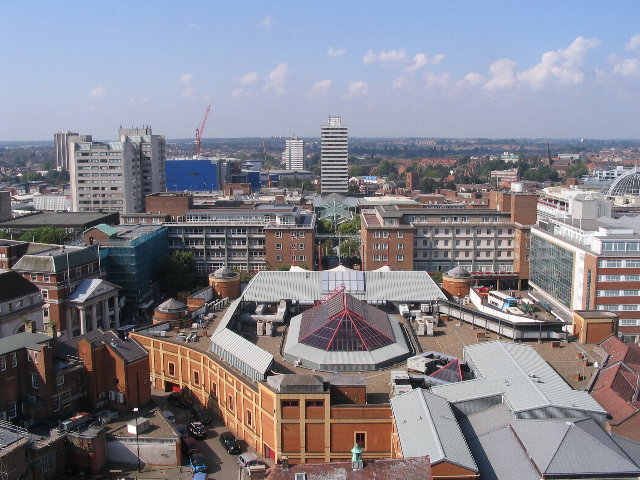
İzahBroadgate and Precincts - geograph.org.uk - 554599.jpg
English: Broadgate and Precincts Taken from the tower of the old cathedral church of St. Michael, looking westwards down the line of the Upper and Lower Precinct shopping areas towards Mercia House[1], the tower block at the bottom end of the Lower Precinct. To the right of Mercia House is the red sandstone tower of St John's Church. To its left a little further into the distance is the Skydome and Odeon complex in Spon Street, partially obscured by the blue blob of Ikea. The grey tower block to the left is Coventry Point in Market Way. In the foreground is the roof of the Cathedral Lanes shopping centre swamping Broadgate. Left foreground is Pepper Lane, running towards High Street.

To see how it looked in 1975, see https://www.geograph.org.uk/photo/156892

and 1983 : https://www.geograph.org.uk/photo/1059854 .
Tarix 13 sentyabr 2007
Mənbə From geograph.org.uk
Müəllif E Gammie
Atribut
(required by the license)
InfoField
E Gammie / Broadgate and Precincts / 
CC BY-SA 2.0
InfoField
E Gammie / Broadgate and Precincts
Camera location52° 24′ 29″ N, 1° 30′ 30″ W  Heading=270° Kartographer map based on OpenStreetMap.View this and other nearby images on: OpenStreetMapinfo 52.408030; -1.508200
Object location52° 24′ 29″ N, 1° 30′ 50″ W  Heading=270° Kartographer map based on OpenStreetMap.View this and other nearby images on: OpenStreetMapinfo 52.408050; -1.514000

Lisenziya

This image was taken from the Geograph project collection. See this photograph's page on the Geograph website for the photographer's contact details. The copyright on this image is owned by E Gammie and is licensed for reuse under the Creative Commons Attribution-ShareAlike 2.0 license.
w:az:Creative Commons
istinad vermək bənzər paylaşma
Bu fayl Creative Commons Attribution-Share Alike 2.0 Generic lisenziyası altında yayımlanır.
Atribut: E Gammie
Siz heç bir məhdudiyyət olmadan:
  • paylaşa bilərsiniz – əsəri köçürə, paylaya və ötürə bilərsiniz
  • remiks edə bilərsiniz – əsəri adaptasiya edə bilərsiniz
Aşağıdakı şərtlərə əməl etməklə:
  • istinad vermək – Müvafiq istinad verməli, lisenziyaya keçid əlavə etməli və dəyişikliklər edilib-edilmədiyini bildirməlisiniz . Siz bunu istənilən şəkildə edə bilərsiniz, lakin lisenziya verənin sizə şəxsən icazə verdiyini göstərən formada yox.
  • bənzər paylaşma – Əsəri remix edirsinizsə, dəyişdirirsinizsə və ya üzərində iş aparırsınızsa, öz töhfələrinizi orijinalda olduğu kimi eyni və ya uyğun lisenziya altında yayımlamalısınız.
https://creativecommons.org/licenses/by-sa/2.0CC BY-SA 2.0 Creative Commons Attribution-Share Alike 2.0 truetrue

Başlıqlar

Bu faylın nəyi təmsil etdiyinə dair bir sətirlik izahat əlavə et
Broadgate and Precincts

Bu faylda təsvir olunan elementlər

təsvir edir

commercial building ingilis

city center ingilis

Coventry ingilis

yaradıcı

Vikidata elementi olmayan bir neçə dəyər

URL: https://www.geograph.org.uk/profile/5838
obyektin rolu: fotoqraf
müəllifin qısa adı: E Gammie

copyright status ingilis

copyrighted ingilis

lisenziya

Creative Commons Attribution-ShareAlike 2.0 Generic ingilis

başlıq: Broadgate and Precincts (ingilis)
müəllifin qısa adı: E Gammie

yaranma tarixi

13 sentyabr 2007

coordinates of the point of view ingilis

52°24'28.91"N, 1°30'29.52"W

heading ingilis: 270 dərəcə

source of file ingilis

file available on the internet ingilis

istifadəçi: Geograph Britain and Ireland ingilis
URL-də təsvir edilmişdir: https://www.geograph.org.uk/photo/554599
geograph.org.uk image ID ingilis: 554599

coordinates of depicted place ingilis

52°24'28.98"N, 1°30'50.40"W

heading ingilis: 270 dərəcə

media type ingilis

image/jpeg

checksum ingilis

765c40fc8df3b2a127741cd782691d7f857428b4

təyinetmə üsulu: SHA-1

data size ingilis

97.903 Bayt

hündürlüyü/boyu

480 piksel

eni

640 piksel

geograph.org.uk image ID ingilis

554599

anlayışın sinfi

fotoqrafiya

yaradılma yeri

Coventry ingilis

Faylın tarixçəsi

Faylın əvvəlki versiyasını görmək üçün gün/tarix bölməsindəki tarixlərə klikləyin.

Tarix/VaxtMiniatürÖlçülərİstifadəçiŞərh
hal-hazırkı02:26, 6 fevral 201102:26, 6 fevral 2011 tarixindəki versiyanın miniatür görüntüsü640 × 480 (96 KB)GeographBot== {{int:filedesc}} == {{Information |description={{en|1=Broadgate and Precincts Taken from the tower of the old cathedral church of St. Michael, looking westwards down the line of the Upper and Lower Precinct shopping areas towards Mercia House[1], the t

Faylın istifadəsi

Aşağıdakı 2 səhifə bu faylı istifadə edir:

  • Birləşmiş Krallıq şəhərlərinin siyahısı
  • Koventri

Faylın qlobal istifadəsi

Bu fayl aşağıdakı vikilərdə istifadə olunur:

  • af.wikipedia.org layihəsində istifadəsi
    • Coventry
  • an.wikipedia.org layihəsində istifadəsi
    • Coventry
  • ar.wikipedia.org layihəsində istifadəsi
    • كوفنتري
  • arz.wikipedia.org layihəsində istifadəsi
    • مدينه كوفنترى
  • ast.wikipedia.org layihəsində istifadəsi
    • Coventry
  • azb.wikipedia.org layihəsində istifadəsi
    • بیرلشمیش شاهلیقین شهرلری
    • کاونتری
  • be-tarask.wikipedia.org layihəsində istifadəsi
    • Ковэнтры
  • be.wikipedia.org layihəsində istifadəsi
    • Ковентры
  • ca.wikipedia.org layihəsində istifadəsi
    • London Wasps
    • Coventry
  • ceb.wikipedia.org layihəsində istifadəsi
    • Coventry (kapital sa kondado)
  • cy.wikipedia.org layihəsində istifadəsi
    • Coventry
  • da.wikipedia.org layihəsində istifadəsi
    • Coventry
  • de.wikipedia.org layihəsində istifadəsi
    • Coventry
  • de.wikivoyage.org layihəsində istifadəsi
    • West Midlands
    • West Midlands (County)
  • diq.wikipedia.org layihəsində istifadəsi
    • Coventry
  • el.wikipedia.org layihəsində istifadəsi
    • Κόβεντρι
  • en.wikipedia.org layihəsində istifadəsi
    • User:Wackslas/mostpopulousuk
  • en.wikivoyage.org layihəsində istifadəsi
    • West Midlands (county)
    • West Midlands (region)
  • eo.wikipedia.org layihəsində istifadəsi
    • Coventry
  • es.wikipedia.org layihəsində istifadəsi
    • Coventry
  • eu.wikipedia.org layihəsində istifadəsi
    • Coventry
  • frr.wikipedia.org layihəsində istifadəsi
    • Coventry
  • fr.wikipedia.org layihəsində istifadəsi
    • Coventry
  • fr.wikivoyage.org layihəsində istifadəsi
    • Angleterre
    • Coventry
    • Midlands de l'Ouest
  • fy.wikipedia.org layihəsində istifadəsi
    • Coventry
  • ga.wikipedia.org layihəsində istifadəsi
    • Coventry
  • gl.wikipedia.org layihəsində istifadəsi
    • Coventry
  • he.wikivoyage.org layihəsində istifadəsi
    • מערב המידלנדס
  • hy.wikipedia.org layihəsində istifadəsi
    • Քովենտրի
  • ku.wikipedia.org layihəsində istifadəsi
    • Coventry
  • lld.wikipedia.org layihəsində istifadəsi
    • Coventry
  • mdf.wikipedia.org layihəsində istifadəsi
    • Ковэнтри
  • mt.wikipedia.org layihəsində istifadəsi
    • Renju Unit
  • mzn.wikipedia.org layihəsində istifadəsi
    • کاونتری
  • nn.wikipedia.org layihəsində istifadəsi
    • Coventry
  • no.wikipedia.org layihəsində istifadəsi
    • Coventry
  • os.wikipedia.org layihəsində istifadəsi
    • Ковентри
  • pl.wikipedia.org layihəsində istifadəsi
    • Coventry
  • pl.wikivoyage.org layihəsində istifadəsi
    • Coventry
  • pnb.wikipedia.org layihəsində istifadəsi
    • کونٹری
  • ro.wikipedia.org layihəsində istifadəsi
    • Coventry
  • ru.wikinews.org layihəsində istifadəsi
    • Категория:Ковентри (Великобритания)
  • sco.wikipedia.org layihəsində istifadəsi
    • Coventry
  • sr.wikipedia.org layihəsində istifadəsi
    • Ковентри

Bu faylın qlobal istifadəsinə baxın.

Mənbə — "https://az.wikipedia.org/wiki/Fayl:Broadgate_and_Precincts_-_geograph.org.uk_-_554599.jpg"
Informasiya Melumat Axtar