Sınaq göstərişi ölçüsü: 556 × 600 piksel. Digər ölçülər: 222 × 240 piksel | 445 × 480 piksel | 777 × 838 piksel.
Faylın orijinalı (777 × 838 piksel, fayl həcmi: 37 KB, MIME növü: image/png)
Bu fayl Vikianbarda yerləşir. Açıqlama səhifəsindəki məlumatlar aşağıda göstərilib. Vikianbar azad lisenziyalı media anbarıdır. Siz də töhfə verə bilərsiniz. |
Xülasə
| İzah |
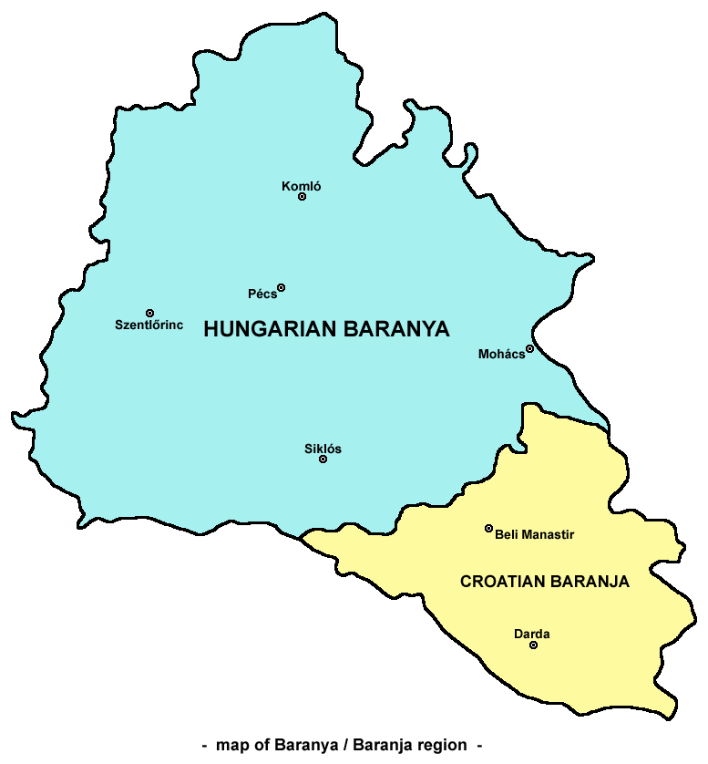
English: Map of Baranya / Baranja region in Hungary and Croatia. Note: it is generally accepted that southern and eastern borders of Baranya / Baranja are rivers Drava and Danube, while north-western borders are less clear. This map show north-western borders of the region in accordance with borders of historical Baranya county in the Kingdom of Hungary, but according to other interpretations, north-western border of Baranya / Baranja is either Mecsek mountain either Balaton lake.
Српски / srpski: Mapa Baranje / zemljovid Baranje u Mađarskoj i Hrvatskoj. Napomena: opšte / opće je prihvaćeno da južnu i istočnu granicu Baranje čine reke / rijeke Drava i Dunav, dok su severozapadne / sjeverozapadne granice manje jasne. Ova mapa / ovaj zemljovid prikazuje severozapadne / sjeverozapadne granice regiona / regije u saglasnosti sa granicama istorijske / povijesne Baranjske županije u Kraljevini Ugarskoj, ali prema drugim interpretacijama, severozapadnu / sjeverozapadnu granicu Baranje čine ili planina Meček ili jezero Balaton. |
| Tarix | 24 may 2006 (original upload date) |
| Mənbə | Transferred from en.wikipedia to Commons. |
| Müəllif | Original uploader and author was PANONIAN at English wikipedia. |
| Digər versiyalar |
|


Lisenziya
Self made map by user:PANONIAN.
| This work has been released into the public domain by its author, PANONIAN at ingilis Vikipediya. This applies worldwide. In some countries this may not be legally possible; if so: PANONIAN grants anyone the right to use this work for any purpose, without any conditions, unless such conditions are required by law. |
References
- Školski istorijski atlas, treće izdanje, Zavod za izdavanje udžbenika Socijalističke Republike Srbije, Beograd, 1970.
- Peter Rokai - Zoltan Đere - Tibor Pal - Aleksandar Kasaš, Istorija Mađara, Beograd, 2002.
- Nada Miletić Stanić, Pravoslavne crkve u Baranji, Novi Sad, 1999.
- Stevan Mihaldžić, Baranja od najstarijih vremena do danas, Beograd, 1991.
- http://upload.wikimedia.org/wikipedia/commons/9/99/Baranya_county_map_(1891).jpg
.jpg)
Orijinal yükləmə gündəliyi
The original description page was here. All following user names refer to en.wikipedia.
- 2006-05-24 00:16 PANONIAN 732×779×8 (32939 bytes)
Faylın tarixçəsi
Faylın əvvəlki versiyasını görmək üçün gün/tarix bölməsindəki tarixlərə klikləyin.
| Tarix/Vaxt | Miniatür | Ölçülər | İstifadəçi | Şərh | |
|---|---|---|---|---|---|
| hal-hazırkı | 10:09, 15 oktyabr 2009 | | 777 × 838 (37 KB) | WikiEditor2004 | |
| 22:42, 16 mart 2007 |  | 732 × 779 (32 KB) | Frokor | {{Information |Description=Map of Baranya/en:Baranja region (self made) |Source=Originally from [http://en.wikipedia.org en.wikipedia]; description page is/was [http://en.wikipedia.org/w/index.php?title=Image%3ABARANYA.png he |
Faylın istifadəsi
Aşağıdakı səhifə bu faylı istifadə edir:
Faylın qlobal istifadəsi
Bu fayl aşağıdakı vikilərdə istifadə olunur:
- ar.wikipedia.org layihəsində istifadəsi
- bg.wikipedia.org layihəsində istifadəsi
- bs.wikipedia.org layihəsində istifadəsi
- cs.wikipedia.org layihəsində istifadəsi
- en.wikipedia.org layihəsində istifadəsi
- es.wikipedia.org layihəsində istifadəsi
- fr.wikipedia.org layihəsində istifadəsi
- hr.wikipedia.org layihəsində istifadəsi
- hu.wikipedia.org layihəsində istifadəsi
- id.wikipedia.org layihəsində istifadəsi
- ko.wikipedia.org layihəsində istifadəsi
- nl.wikipedia.org layihəsində istifadəsi
- nn.wikipedia.org layihəsində istifadəsi
- no.wikipedia.org layihəsində istifadəsi
- pl.wikipedia.org layihəsində istifadəsi
- pt.wikipedia.org layihəsində istifadəsi
- ro.wikipedia.org layihəsində istifadəsi
- ru.wikipedia.org layihəsində istifadəsi
- sh.wikipedia.org layihəsində istifadəsi
- sk.wikipedia.org layihəsində istifadəsi
- sv.wikipedia.org layihəsində istifadəsi
- tr.wikipedia.org layihəsində istifadəsi
- uk.wikipedia.org layihəsində istifadəsi
- www.wikidata.org layihəsində istifadəsi
- zh.wikipedia.org layihəsində istifadəsi
- zh.wikivoyage.org layihəsində istifadəsi