
Bu SVG-faylın PNG formatındakı bu görünüşünün ölçüsü: 776 × 600 piksel. Digər ölçülər: 311 × 240 piksel | 621 × 480 piksel | 994 × 768 piksel | 1.280 × 989 piksel | 2.560 × 1.978 piksel | 783 × 605 piksel.
Faylın orijinalı (SVG faylı, nominal olaraq 783 × 605 piksel, faylın ölçüsü: 245 KB)
Bu fayl Vikianbarda yerləşir. Açıqlama səhifəsindəki məlumatlar aşağıda göstərilib. Vikianbar azad lisenziyalı media anbarıdır. Siz də töhfə verə bilərsiniz. |
| İzah |
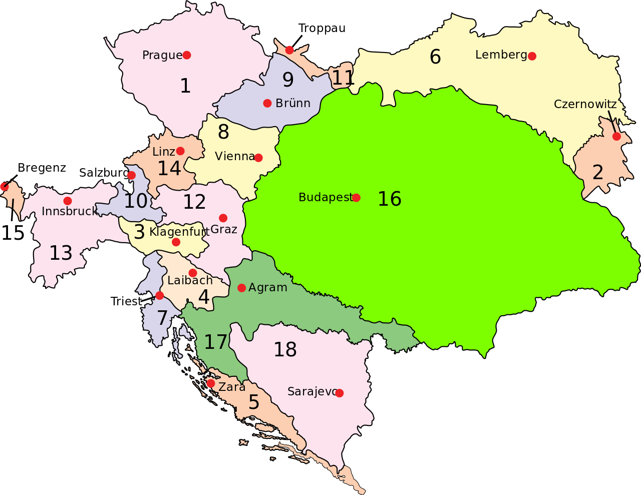
English: Austria–Hungary: Empire of Austria (Cisleithania): 1. Bohemia, 2. Bukovina, 3. Carinthia, 4. Carniola, 5. Dalmatia, 6. Galicia, 7. Küstenland, 8. Lower Austria, 9. Moravia, 10. Salzburg, 11. Silesia, 12. Styria, 13. Tyrol, 14. Upper Austria, 15. Vorarlberg; Kingdom of Hungary (Transleithania): 16. Hungary proper 17. Croatia-Slavonia; Austrian-Hungarian Condominium: 18. Bosnia and Herzegovina Deutsch: Österreich-Ungarn 1910: Cisleithanien: 1. Böhmen, 2. Bukowina, 3. Kärnten, 4. Krain, 5. Dalmatien, 6. Galizien, 7. Küstenland, 8. Österreich unter der Enns, 9. Mähren, 10. Salzburg, 11. Schlesien, 12. Steiermark, 13. Tirol, 14. Österreich ob der Enns, 15. Vorarlberg; Transleithanien: 16. Ungarn, 17. Kroatien und Slawonien; 18. Bosnien und Herzegowina Čeština: Rakousko-Uhersko: Rakouské císařství: 1. České země, 2. Bukovina, 3. Korutany, 4. Kraňsko, 5. Dalmácie, 6. Halič, 7. Rakouské přímoří, 8. Dolní Uhry, 9. Morava, 10. Salcbursko (Solnohradsko), 11. Slezsko, 12. Štýrsko, 13. Tyroly, 14. Horní Uhry, 15. Vorarlbersko; Uherské země: 16. Uhry (Horní a Dolní) 17. Chorvatsko-Slavonie; Rakousko-Uherský kondominát: 18. Bosna a Hercegovina |
||
| Tarix | (UTC) | ||
| Mənbə | |||
| Müəllif |
|
||
| İcazə (Faylın təkrar istifadəsi) |
|
||
| Digər versiyalar | Derivative works of this file: Austria-Hungary map hu.svgImage:Austria-Hungary map-blank.svg, for more maps derived from this template see Category:Maps of Austria-Hungary ssp. or whatlinks |
[[Category:Maps of th
|Permission= |other_versions= }}
| Bu təsvirin si, orijinala əsaslanaraq rəqəmsal qaydadadır. Dəyişiklik: Capital of Dalmatia (5) was Zara today Zadar. İlkin təsvir buradadır: Austria-Hungary map.svg.
|
Mən, bu işin müəllif hüquqları sahibi, onu aşağıdakı lisenziyaya əsasən dərc edirəm:
| This work has been released into the public domain by its author, Example, at the ingilis Vikipediya project. This applies worldwide. In case this is not legally possible: |
Orijinal yükləmə gündəliyi
This image is a derivative work of the following images:
- File:Austria-Hungary_map.svg licensed with PD-user-w
Uploaded with derivativeFX
Faylın tarixçəsi
Faylın əvvəlki versiyasını görmək üçün gün/tarix bölməsindəki tarixlərə klikləyin.
| Tarix/Vaxt | Miniatür | Ölçülər | İstifadəçi | Şərh | |
|---|---|---|---|---|---|
| hal-hazırkı | 12:28, 20 fevral 2009 | | 783 × 605 (245 KB) | Ivh123 | {{Information |Description={{en| <br>'''<u>Austria–Hungary</u>''':<br>'''Empire of Austria (Cisleithania)''': 1. Bohemia, 2. Bukovina, 3. Carinthia, 4. Carniola, 5. Dalmatia, 6. Galicia, 7. Küstenland, 8. Lower Austria, 9. Moravia, 10. Salzburg, 11. Si |
Faylın istifadəsi
Aşağıdakı səhifə bu faylı istifadə edir:
Faylın qlobal istifadəsi
Bu fayl aşağıdakı vikilərdə istifadə olunur:
- ar.wikipedia.org layihəsində istifadəsi
- azb.wikipedia.org layihəsində istifadəsi
- bn.wikipedia.org layihəsində istifadəsi
- el.wikipedia.org layihəsində istifadəsi
- en.wikipedia.org layihəsində istifadəsi
- History of Croatia
- House of Habsburg
- Yugoslav Committee
- Multinational state
- Portal:Croatia
- Croatian–Hungarian Settlement
- Wikipedia:Reference desk/Archives/Humanities/2010 November 19
- Green Cadres
- May Declaration
- National Council of Slovenes, Croats and Serbs
- Dissolution of Austria-Hungary
- Zagreb Resolution
- User:Falcaorib/Austria-Hungary
- Progressive Youth (Croatia)
- User:JMvanDijk/Sandbox 9/Box 4/Box 1
- eo.wikipedia.org layihəsində istifadəsi
- et.wikipedia.org layihəsində istifadəsi
- fa.wikipedia.org layihəsində istifadəsi
- hr.wikipedia.org layihəsində istifadəsi
- hu.wikipedia.org layihəsində istifadəsi
- hy.wikipedia.org layihəsində istifadəsi
- id.wikipedia.org layihəsində istifadəsi
- it.wikipedia.org layihəsində istifadəsi
- ko.wikipedia.org layihəsində istifadəsi
- lt.wikipedia.org layihəsində istifadəsi
- lv.wikipedia.org layihəsində istifadəsi
- nl.wikipedia.org layihəsində istifadəsi
- pnb.wikipedia.org layihəsində istifadəsi
- pt.wikipedia.org layihəsində istifadəsi
- ru.wikipedia.org layihəsində istifadəsi
- sh.wikipedia.org layihəsində istifadəsi
Bu faylın qlobal istifadəsinə baxın.