Sınaq göstərişi ölçüsü: 800 × 322 piksel. Digər ölçülər: 320 × 129 piksel | 640 × 257 piksel.
Faylın orijinalı (1.493 × 600 piksel, fayl həcmi: 163 KB, MIME növü: image/jpeg)
Bu fayl Vikianbarda yerləşir. Açıqlama səhifəsindəki məlumatlar aşağıda göstərilib. Vikianbar azad lisenziyalı media anbarıdır. Siz də töhfə verə bilərsiniz. |
| İzah |
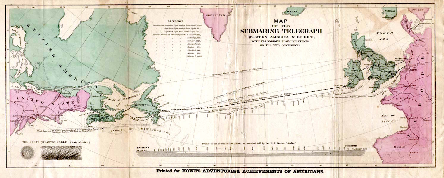
English: Map of the 1858 Atlantic Cable route (from http://atlantic-cable.com/Maps/index.htm).
Français : Carte des routes de câbles sous-marins transatlatiques de 1858.
Русский: Карта прокладки телеграфного кабеля через Атлантику в 1858 г.
Українська: Карта першого трансатлантичного телеграфного кабеля в 1858 р. |
| Tarix | the 1858 |
| Mənbə | Howe's Adventures & Achievements of Americans; en:Image:Atlantic_cable_Map.jpg |
| Müəllif | Naməlum |
| İcazə (Faylın təkrar istifadəsi) |
English: Image is out of copyright, but the scan used here was sourced from http://atlantic-cable.com/Maps/index.htm without my permission (I am the site owner). I grant permission for use of the scan on Wikipedia.
Українська: Зображення не захищене авторським правом, але сканування, яке тут використовується, було отримано з http://atlantic-cable.com/Maps/index.htm без мого дозволу (я власник сайту). Надаю дозвіл на використання сканування у Вікіпедії. |
|
This work is in the public domain in its country of origin and other countries and areas where the copyright term is the author's life plus 70 years or fewer. You must also include a United States public domain tag to indicate why this work is in the public domain in the United States. | |
| Bu fayl bütün əlaqəli və qonşu hüquqlar da daxil olmaqla, müəllif hüquqları qanununa əsasən məlum məhdudiyyətlərdən azad olduğu müəyyən edilmişdir. | |
This media file is in the public domain in the United States. This applies to U.S. works where the copyright has expired, often because its first publication occurred prior to January 1, 1930, and if not then due to lack of notice or renewal. See this page for further explanation.
|
 | |
Faylın tarixçəsi
Faylın əvvəlki versiyasını görmək üçün gün/tarix bölməsindəki tarixlərə klikləyin.
| Tarix/Vaxt | Miniatür | Ölçülər | İstifadəçi | Şərh | |
|---|---|---|---|---|---|
| hal-hazırkı | 14:35, 29 yanvar 2018 | 1.493 × 600 (163 KB) | Soerfm | Color, brightness | |
| 15:53, 9 mart 2006 | 1.493 × 600 (136 KB) | Jailbird | Map of the 1858 Atlantic Cable route from Frank Leslie's Illustrated Newspaper, August 21, 1858 from en:Image:Atlantic_cable_Map.jpg {{PD-Old}} |
Faylın istifadəsi
Aşağıdakı səhifə bu faylı istifadə edir:
Faylın qlobal istifadəsi
Bu fayl aşağıdakı vikilərdə istifadə olunur:
- be-tarask.wikipedia.org layihəsində istifadəsi
- bs.wikipedia.org layihəsində istifadəsi
- ca.wikipedia.org layihəsində istifadəsi
- cs.wikipedia.org layihəsində istifadəsi
- de.wikipedia.org layihəsində istifadəsi
- en.wikipedia.org layihəsində istifadəsi
- en.wikibooks.org layihəsində istifadəsi
- en.wikivoyage.org layihəsində istifadəsi
- eo.wikipedia.org layihəsində istifadəsi
- es.wikipedia.org layihəsində istifadəsi
- et.wikipedia.org layihəsində istifadəsi
- eu.wikipedia.org layihəsində istifadəsi
- fa.wikipedia.org layihəsində istifadəsi
- fi.wikipedia.org layihəsində istifadəsi
- fr.wikipedia.org layihəsində istifadəsi
- 1866
- Câble sous-marin
- Extel
- Câbles télégraphiques transatlantiques
- Discussion:Câbles télégraphiques transatlantiques
- Wikipédia:Statistiques des anecdotes de la page d'accueil/Visibilité des anecdotes (2021)
- Discussion:Câbles télégraphiques transatlantiques/LSV 19995
- Wikipédia:Statistiques des anecdotes de la page d'accueil/Visibilité des anecdotes (2021)/2021 04
- Wikipédia:Réseaux sociaux/Publications/archives/avril 2021
- Wikipédia:Le saviez-vous ?/Archives/2021
- Wikipédia:Le Bistro/5 août 2022
- Télégraphie électrique
- gd.wikipedia.org layihəsində istifadəsi
- id.wikipedia.org layihəsində istifadəsi
- io.wikipedia.org layihəsində istifadəsi
- it.wikipedia.org layihəsində istifadəsi
- ja.wikipedia.org layihəsində istifadəsi
- kk.wikipedia.org layihəsində istifadəsi
Bu faylın qlobal istifadəsinə baxın.