
Bu fayl Vikianbarda yerləşir. Açıqlama səhifəsindəki məlumatlar aşağıda göstərilib. Vikianbar azad lisenziyalı media anbarıdır. Siz də töhfə verə bilərsiniz. |
Xülasə
| İzah |
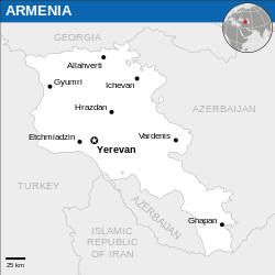
Català: Mapa de localització d'Armenia.
English: Locator map of Armenia. |
| Tarix | |
| Mənbə |
English: Armenia Locator Map (ReliefWeb), ESRI, UNCS |
| Müəllif | |
| Digər versiyalar |
File:Armenia - Location Map (2013) - ARM - UNOCHA.svg contains 3 translations.
|
| SVG genesis |
_-_ARM_-_UNOCHA.svg&lang=ca)
_-_ARM_-_UNOCHA.svg&lang=en)
_-_ARM_-_UNOCHA.svg&lang=id)
_-_ARM_-_UNOCHA.svg)
_-_ARM_-_UNOCHA.svg&action=edit&redlink=1)
_-_ARM_-_UNOCHA.svg)
| This SVG file contains embedded text that can be translated into your language, using any capable SVG editor, text editor or the SVG Translate tool. For more information see: About translating SVG files. |
_-_ARM_-_UNOCHA.svg)
This file is translated using SVG <switch> elements. All translations are stored in the same file! Learn more.
For most Wikipedia projects, you can embed the file normally (without a To translate the text into your language, you can use the SVG Translate tool. Alternatively, you can download the file to your computer, add your translations using whatever software you're familiar with, and re-upload it with the same name. You will find help in Graphics Lab if you're not sure how to do this. |
Lisenziya
- Siz heç bir məhdudiyyət olmadan:
- paylaşa bilərsiniz – əsəri köçürə, paylaya və ötürə bilərsiniz
- remiks edə bilərsiniz – əsəri adaptasiya edə bilərsiniz
- Aşağıdakı şərtlərə əməl etməklə:
- istinad vermək – Müvafiq istinad verməli, lisenziyaya keçid əlavə etməli və dəyişikliklər edilib-edilmədiyini bildirməlisiniz . Siz bunu istənilən şəkildə edə bilərsiniz, lakin lisenziya verənin sizə şəxsən icazə verdiyini göstərən formada yox.
 This map is part of a collection of 216 free country maps, created by the UN Office for the Coordination of Humanitarian Affairs (OCHA), to be used in print, web or broadcast products.
The ReliefWeb Location Maps released here are maps that highlight a country, its capital, major populated places and the surrounding regions. Attribution Requirements
Using the map without modifications: ensure that the sources and the disclaimer are below the map. Credit as follows: "Credit: OCHA". For use with alteration: remove the OCHA logo and disclaimer following any modification to the map, but keep the data sources as mentioned below the map. Credit the modified map as follows: "Based on OCHA map". You are responsible for the content of your map. We are keen to receive your feedback and hear how you used OCHA's maps. We would be grateful if you would notify us by e-mail and share your work with us. UN Disclaimer
The designations employed and the presentation of material of this map do not imply the expression of any opinion whatsoever on the part of the Secretariat of the United Nations concerning the legal status of any country, territory, city or area or of its authorities or concerning the delimitation of its frontiers or boundaries. |
Textual information (e.g. timestamp) once visible in the image itself has been moved into the image metadata and/or image description page. This makes the image easier to reuse and more language-neutral, and makes the text easier to process and search for. Commons discourages placing visible textual information in images. All licenses accepted on Commons permit this type of modification as a derivative work.
If attribution information were removed and the image is not public domain, replace this tag with {{Attribution metadata from licensed image}}.
|
Faylın tarixçəsi
Faylın əvvəlki versiyasını görmək üçün gün/tarix bölməsindəki tarixlərə klikləyin.
| Tarix/Vaxt | Miniatür | Ölçülər | İstifadəçi | Şərh | |
|---|---|---|---|---|---|
| hal-hazırkı | 01:50, 23 dekabr 2022 | | 250 × 250 (713 KB) | Wikijahnn | File uploaded using svgtranslate tool (https://svgtranslate.toolforge.org/). Added translation for ca. |
| 13:34, 9 mart 2022 |  | 250 × 250 (711 KB) | Nyilvoskt | File uploaded using svgtranslate tool (https://svgtranslate.toolforge.org/). Added translation for id. | |
| 20:43, 5 yanvar 2016 |  | 250 × 250 (709 KB) | Wereldburger758 | Resized page to drawing. Removal watermark. Validation of image. | |
| 20:46, 24 fevral 2014 |  | 254 × 254 (715 KB) | Jeremyb | xslt v2b | |
| 20:41, 10 fevral 2014 |  | 250 × 250 (1,73 MB) | Pharos | {{Information |description={{en|1=Locator Map of Armenia. {{OCHA map}}}} |date=February 2014 |source=UN Office for the Coordination of Humanitarian Affairs (OCHA) |author=[[w:Unit... |
Faylın istifadəsi
Aşağıdakı səhifə bu faylı istifadə edir:
Faylın qlobal istifadəsi
Bu fayl aşağıdakı vikilərdə istifadə olunur:
- ca.wikipedia.org layihəsində istifadəsi
- en.wikipedia.org layihəsində istifadəsi
- es.wikipedia.org layihəsində istifadəsi
- fr.wikipedia.org layihəsində istifadəsi
- gor.wikipedia.org layihəsində istifadəsi
- id.wikipedia.org layihəsində istifadəsi
- kge.wikipedia.org layihəsində istifadəsi
- ru.wikipedia.org layihəsində istifadəsi
- sat.wikipedia.org layihəsində istifadəsi
- so.wikipedia.org layihəsində istifadəsi
- ts.wikipedia.org layihəsində istifadəsi
- uk.wikipedia.org layihəsində istifadəsi
_-_ARM_-_UNOCHA.svg)