Butun axtardiqlarinizi tapmaq ucun buraya: DAXIL OLUN
  Mp4 Mp3 Axtar Yukle
  Video Axtar Yukle
  Shekil Axtar Yukle
  Informasiya Melumat Axtar
  Hazir Inshalar Toplusu
  AZERI CHAT + Tanishliq
  1-11 Sinif Derslikler Yukle
  Saglamliq Tibbi Melumat
  Whatsapp Plus Yukle(Yeni)

  • Ana səhifə
  • Təsadüfi
  • Yaxınlıqdakılar
  • Daxil ol
  • Nizamlamalar
İndi ianə et Əgər Vikipediya sizin üçün faydalıdırsa, bu gün ianə edin.

Fayl:Afghanistan region during 500 BC.jpg

  • Fayl
  • Müzakirə
  • Vikianbar üzərindən baxış
  • Lokal izah əlavə et
  • Fayl
  • Faylın tarixçəsi
  • Faylın istifadəsi
  • Faylın qlobal istifadəsi
  • Metaməlumatlar
Fayl:Afghanistan region during 500 BC.jpg
Daha yüksək versiyası yoxdur.
Afghanistan_region_during_500_BC.jpg (348 × 347 piksel, fayl həcmi: 56 KB, MIME növü: image/jpeg)
Bu fayl Vikianbarda yerləşir. Açıqlama səhifəsindəki məlumatlar aşağıda göstərilib.
Vikianbar azad lisenziyalı media anbarıdır. Siz də töhfə verə bilərsiniz.
İzahAfghanistan region during 500 BC.jpg
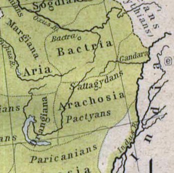
Español: Mapa histórico del Imperio Aqueménida.
English: Historic map of the Achaemenid Empire
Français : Carte historique de l'empire achéménide
Arachosia, Aria and Bactria were the ancient satraps of the Persian Achaemenid Empire that made up most of what is now Afghanistan and western Pakistan during 500 B.C. The main inhabitants of Arachosia were known as Pactyans, whose name possibly survives in today's Pakhtuns.
Tarix 1923
Mənbə

http://www.lib.utexas.edu/maps/historical/history_asia.html

http://www.lib.utexas.edu/maps/historical/shepherd/persian_empire.jpg
Müəllif William R. Shepherd (b. 1871 - d. 1934)
İcazə
(Faylın təkrar istifadəsi)
Public domainPublic domainfalsefalse
Public domain

This work is in the public domain in its country of origin and other countries and areas where the copyright term is the author's life plus 70 years or fewer.


You must also include a United States public domain tag to indicate why this work is in the public domain in the United States.
 Note that a few countries have copyright terms longer than 70 years: Mexico has 100 years, Jamaica has 95 years, Colombia has 80 years, and Guatemala and Samoa have 75 years. This image may not be in the public domain in these countries, which moreover do not implement the rule of the shorter term. Honduras has a general copyright term of 75 years, but it does implement the rule of the shorter term. Copyright may extend on works created by French who died for France in World War II (more information), Russians who served in the Eastern Front of World War II (known as the Great Patriotic War in Russia) and posthumously rehabilitated victims of Soviet repressions (more information).
Bu fayl bütün əlaqəli və qonşu hüquqlar da daxil olmaqla, müəllif hüquqları qanununa əsasən məlum məhdudiyyətlərdən azad olduğu müəyyən edilmişdir.
https://creativecommons.org/publicdomain/mark/1.0/PDMCreative Commons Public Domain Mark 1.0falsefalse
Digər versiyalar File:Map of the Achaemenid Empire.jpg (full)

Başlıqlar

Bu faylın nəyi təmsil etdiyinə dair bir sətirlik izahat əlavə et

Bu faylda təsvir olunan elementlər

təsvir edir

copyright status ingilis

ictimai mülkiyyət

yaranma tarixi

1923

media type ingilis

image/jpeg

checksum ingilis

b4c7eb3a6331a88f235720771aa4cb7956e30af9

təyinetmə üsulu: SHA-1

data size ingilis

57.525 Bayt

hündürlüyü/boyu

347 piksel

eni

348 piksel

Faylın tarixçəsi

Faylın əvvəlki versiyasını görmək üçün gün/tarix bölməsindəki tarixlərə klikləyin.

Tarix/VaxtMiniatürÖlçülərİstifadəçiŞərh
hal-hazırkı13:48, 12 mart 201013:48, 12 mart 2010 tarixindəki versiyanın miniatür görüntüsü348 × 347 (56 KB)Officer{{Information |Description={{es|Mapa histórico del imperio Aqueménido.}} {{en|Historic map of the Achaemenid Empire}} {{fr|Carte historique de l'empire achéménide}} |Source=http://www.lib.utexas.edu/maps/historical/history_asia.html http://www.lib.ut
20:47, 21 yanvar 201020:47, 21 yanvar 2010 tarixindəki versiyanın miniatür görüntüsü324 × 357 (63 KB)Officer{{Information |Description={{es|Mapa histórico del imperio Aqueménido.}} {{en|Historic map of the Achaemenid Empire}} {{fr|Carte historique de l'empire achéménide}} |Source=http://www.lib.utexas.edu/maps/historical/history_asia.html http://www.lib.ut

Faylın istifadəsi

Aşağıdakı səhifə bu faylı istifadə edir:

  • Dürand xətti

Faylın qlobal istifadəsi

Bu fayl aşağıdakı vikilərdə istifadə olunur:

  • am.wikipedia.org layihəsində istifadəsi
    • ባክትሪያ
  • ar.wikipedia.org layihəsində istifadəsi
    • خط ديورند
    • لغات تخارية
    • أراكوسيا
  • azb.wikipedia.org layihəsində istifadəsi
    • پوشتون‌لار
  • bg.wikipedia.org layihəsində istifadəsi
    • Арахозия
  • bn.wikipedia.org layihəsində istifadəsi
    • আফগানিস্তানের ইতিহাস
    • ডুরান্ড লাইন
    • পশতুনিস্তান
  • ca.wikipedia.org layihəsində istifadəsi
    • Aracòsia
    • Paixtus
  • de.wikipedia.org layihəsində istifadəsi
    • Paschtunen
  • en.wikipedia.org layihəsində istifadəsi
    • Ancient history of Afghanistan
    • History of Afghanistan
    • Pashtuns
    • Pashtunistan
    • Durand Line
    • Farah Province
    • Arachosia
    • Theories of Pashtun origin
    • Arghandab River
    • Portal:Afghanistan
    • User talk:LastDoge
    • User:Ryanmhorne/pleiades List
    • User:Northamerica1000/Portals of the world
    • User:Lodzdeena/Əfqanıstan tarixi
    • User:Falcaorib/Afghanistan
  • eo.wikipedia.org layihəsində istifadəsi
    • Araĥozio
  • es.wikipedia.org layihəsində istifadəsi
    • Pueblo pastún
  • fa.wikipedia.org layihəsində istifadəsi
    • پشتون‌ها
  • he.wikipedia.org layihəsində istifadəsi
    • היסטוריה של אפגניסטן
    • גבול אפגניסטן-פקיסטן
  • hi.wikipedia.org layihəsində istifadəsi
    • अराकोसिया
  • hr.wikipedia.org layihəsində istifadəsi
    • Arahozija
  • id.wikipedia.org layihəsində istifadəsi
    • Garis Durand
  • it.wikipedia.org layihəsində istifadəsi
    • Battriana
    • Aracosia
  • ja.wikipedia.org layihəsində istifadəsi
    • アフガニスタン
  • ka.wikipedia.org layihəsində istifadəsi
    • არაქოზია
  • lt.wikipedia.org layihəsində istifadəsi
    • Arachosija
  • mn.wikipedia.org layihəsində istifadəsi
    • Афганистан
  • pt.wikipedia.org layihəsində istifadəsi
    • Aracósia
  • ro.wikipedia.org layihəsində istifadəsi
    • Arachosia
  • ru.wikipedia.org layihəsində istifadəsi
    • Арахозия
    • Пуштунистан
    • Доисламская история Афганистана
  • sh.wikipedia.org layihəsində istifadəsi
    • Arahozija
    • Iranska teorija o porijeklu Hrvata
  • sk.wikipedia.org layihəsində istifadəsi
    • Dejiny Afganistanu
  • sr.wikipedia.org layihəsində istifadəsi
    • Историја Авганистана

Bu faylın qlobal istifadəsinə baxın.

Metaməlumatlar

Bu faylda fotoaparat və ya skanerlə əlavə olunmuş məlumatlar var. Əgər fayl sonradan olunubsa, bəzi parametrlər bu şəkildə göstərilənlərdən fərqli ola bilər.

OrientasiyaNormal
Faylın dəyişməsi tarixi və vaxtı18:43, 12 mart 2010
Unique image ID48CAE840EE48415297A8283DF293FCD4
Mənbə — "https://az.wikipedia.org/wiki/Fayl:Afghanistan_region_during_500_BC.jpg"
Informasiya Melumat Axtar