Butun axtardiqlarinizi tapmaq ucun buraya: DAXIL OLUN
  Mp4 Mp3 Axtar Yukle
  Video Axtar Yukle
  Shekil Axtar Yukle
  Informasiya Melumat Axtar
  Hazir Inshalar Toplusu
  AZERI CHAT + Tanishliq
  1-11 Sinif Derslikler Yukle
  Saglamliq Tibbi Melumat
  Whatsapp Plus Yukle(Yeni)

  • Ana səhifə
  • Təsadüfi
  • Yaxınlıqdakılar
  • Daxil ol
  • Nizamlamalar
İndi ianə et Əgər Vikipediya sizin üçün faydalıdırsa, bu gün ianə edin.

Fayl:Aerial view Loos-Hulluch trench system July 1917.jpg

  • Fayl
  • Müzakirə
  • Vikianbar üzərindən baxış
  • Lokal izah əlavə et
  • Fayl
  • Faylın tarixçəsi
  • Faylın istifadəsi
  • Faylın qlobal istifadəsi
  • Metaməlumatlar
Fayl:Aerial view Loos-Hulluch trench system July 1917.jpg
Sınaq göstərişi ölçüsü: 516 × 599 piksel. Digər ölçülər: 207 × 240 piksel | 413 × 480 piksel | 661 × 768 piksel | 882 × 1.024 piksel | 1.432 × 1.663 piksel.
Faylın orijinalı (1.432 × 1.663 piksel, fayl həcmi: 1,01 MB, MIME növü: image/jpeg)
Bu fayl Vikianbarda yerləşir. Açıqlama səhifəsindəki məlumatlar aşağıda göstərilib.
Vikianbar azad lisenziyalı media anbarıdır. Siz də töhfə verə bilərsiniz.
İzahAerial view Loos-Hulluch trench system July 1917.jpg
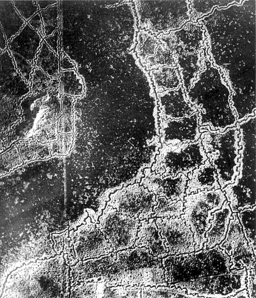
English: An aerial reconnaissance photograph of the opposing trenches and no-man's land between Loos-en-Gohelle and Hulluch in Artois, France, taken at 7.15 pm, 22 July 1917. German trenches are at the right and bottom, British trenches are at the top left. The vertical line to the left of centre indicates the course of a pre-war road or track.

The location is Hill 70, attacked and taken between 15 and 25 August 1917 by the Canadian Corps.

Français : Photographie de reconnaissance aérienne des tranchées adverses et du no-man's-land qui les sépare. Les tranchées allemandes sont en bas à droite, les tranchées à gauches sont anglaises. La ligne verticale sur la gauche est tout ce qui reste d'une route. Photo prise entre Loos et Hulluch, en Artois (France) à 19h15, le 22 juillet 1917.
Русский: Аэрофотосъемка траншей (окопов) и ходов сообщения противников и разделяющей их ничейной земли, Западноевропейский театр войны. Справа внизу немецкие окопы, слева — английские, канадские. Вертикальная линия слева — это всё, что осталось от дороги. Аэроснимок сделан между Лоосом и Хюлухом, в Артуа (Франция) в 19.15, 22 июля 1917 года.
Tarix 22 iyul 1917
Mənbə
Image of the exterior main entrance to the Imperial War Museum in London. This photograph Q 45786 comes from the collections of the Imperial War Museums
(collection no. 1900-03)
Flag of the United Kingdom.
Müəllif NaməlumUnknown author
İcazə
(Faylın təkrar istifadəsi)
Public domainPublic domainfalsefalse
Public domain
This work created by the United Kingdom Government is in the public domain.

This is because it is one of the following:

  1. It is a photograph taken prior to 1 June 1957; or
  2. It was published prior to 1975; or
  3. It is an artistic work other than a photograph or engraving (e.g. a painting) which was created prior to 1975.

HMSO has declared that the expiry of Crown Copyrights applies worldwide (ref: HMSO Email Reply)
More information.

See also Copyright and Crown copyright artistic works.

Deutsch ∙ English ∙ Español ∙ français ∙ italiano ∙ Nederlands ∙ polski ∙ português ∙ sicilianu ∙ slovenščina ∙ suomi ∙ Türkçe ∙ македонски ∙ русский ∙ українська ∙ മലയാളം ∙ 한국어 ∙ 日本語 ∙ 简体中文 ∙ 繁體中文 ∙ العربية ∙ +/−

Camera location50° 28′ 18″ N, 2° 48′ 21″ E Kartographer map based on OpenStreetMap.View this and other nearby images on: OpenStreetMapinfo 50.471667; 2.805833

Note: Location is approximate.

VI seal
Valued image

This image has been assessed under the valued image criteria and is considered the most valued image on Commons within the scope: World War I trench systems, aerial view. You can see its nomination here.

Başlıqlar

Bu faylın nəyi təmsil etdiyinə dair bir sətirlik izahat əlavə et

Bu faylda təsvir olunan elementlər

təsvir edir

copyright status ingilis

ictimai mülkiyyət

anlayışın sinfi

ağ-qara fotoqrafiya

aerofotoşəkil

Commons quality assessment ingilis

Wikimedia Commons valued image ingilis

başlama tarixi: 12 iyun 2008

yaranma tarixi

22 iyul 1917Qriqori təqvimi

coordinates of the point of view ingilis

50°28'18.001"N, 2°48'20.999"E

media type ingilis

image/jpeg

data size ingilis

1.054.509 Bayt

hündürlüyü/boyu

1.663 piksel

eni

1.432 piksel

checksum ingilis

f5cf44ff0d6369e0af6c6ba32a25eccfdb30b5aa

təyinetmə üsulu: SHA-1

Faylın tarixçəsi

Faylın əvvəlki versiyasını görmək üçün gün/tarix bölməsindəki tarixlərə klikləyin.

Tarix/VaxtMiniatürÖlçülərİstifadəçiŞərh
hal-hazırkı15:15, 13 fevral 202515:15, 13 fevral 2025 tarixindəki versiyanın miniatür görüntüsü1.432 × 1.663 (1,01 MB)Ichmatch prior crop
15:12, 13 fevral 202515:12, 13 fevral 2025 tarixindəki versiyanın miniatür görüntüsü2.243 × 1.748 (1,46 MB)Ichlarger
03:12, 16 yanvar 201203:12, 16 yanvar 2012 tarixindəki versiyanın miniatür görüntüsü742 × 864 (542 KB)CentpacrrRemove text.
05:49, 10 dekabr 200505:49, 10 dekabr 2005 tarixindəki versiyanın miniatür görüntüsü767 × 864 (243 KB)Gsl~commonswiki{{PD-BritishGov}}

Faylın istifadəsi

Aşağıdakı səhifə bu faylı istifadə edir:

  • Neytral zona

Faylın qlobal istifadəsi

Bu fayl aşağıdakı vikilərdə istifadə olunur:

  • arz.wikipedia.org layihəsində istifadəsi
    • ارض ماحدش يملكها
    • حرب خنادق
  • ast.wikipedia.org layihəsində istifadəsi
    • Guerra de trincheres
  • be-tarask.wikipedia.org layihəsində istifadəsi
    • Акоп
  • be.wikipedia.org layihəsində istifadəsi
    • Нічыйная зямля
  • bg.wikipedia.org layihəsində istifadəsi
    • Ничия земя
  • bn.wikipedia.org layihəsində istifadəsi
    • অমিমাংসিত ভূমি
  • br.wikipedia.org layihəsində istifadəsi
    • Hulluch
  • ca.wikipedia.org layihəsində istifadəsi
    • Guerra de trinxeres
    • Terra de ningú (guerra)
  • da.wikipedia.org layihəsində istifadəsi
    • Skyttegrav
    • Teknologi under 1. verdenskrig
  • de.wikipedia.org layihəsində istifadəsi
    • Benutzer:Rahn schießt!/MonkeesTVSerie
  • en.wikipedia.org layihəsində istifadəsi
    • Trench warfare
    • No man's land
    • Gas attacks at Hulluch
    • Wikipedia:Graphics Lab/Photography workshop/Eight Requests/Archive/2012
    • Frederick Charles Victor Laws
  • es.wikipedia.org layihəsində istifadəsi
    • Guerra de trincheras
    • Tierra de nadie (guerra)
  • et.wikipedia.org layihəsində istifadəsi
    • Hulluch
  • eu.wikipedia.org layihəsində istifadəsi
    • Inorena ez den lur
  • fa.wikipedia.org layihəsində istifadəsi
    • منطقه بی‌طرف
  • fi.wikipedia.org layihəsində istifadəsi
    • Juoksuhauta
  • fr.wikipedia.org layihəsində istifadəsi
    • Loos-en-Gohelle
    • Guerre de tranchées
    • Hulluch
    • Utilisateur:Wart Dark/Guerre de tranchée
    • Bataille d'Hulluch
    • Utilisateur:Skiff/A illustrer
    • Utilisateur:Thib Phil/Bac à sable 17
  • fr.wikiversity.org layihəsində istifadəsi
    • Guerres au XXe siècle/Première Guerre mondiale
  • gl.wikipedia.org layihəsində istifadəsi
    • Guerra de trincheiras
  • hu.wikipedia.org layihəsində istifadəsi
    • Lövészárok-hadviselés
  • hy.wikipedia.org layihəsində istifadəsi
    • Ոչ մեկի հող
  • id.wikipedia.org layihəsində istifadəsi
    • Tanah tak bertuan
  • it.wikipedia.org layihəsində istifadəsi
    • Fronte occidentale (1914-1918)
    • Guerra di trincea
    • Terra di nessuno
  • it.wikiquote.org layihəsində istifadəsi
    • Terra di nessuno
  • ja.wikipedia.org layihəsində istifadəsi
    • 塹壕
    • 機甲戦
    • 無人地帯
  • ko.wikipedia.org layihəsində istifadəsi
    • 무인지대
  • ml.wikipedia.org layihəsində istifadəsi
    • പുറമ്പോക്കുകൾ (അന്തർദ്ദേശീയം)
  • ms.wikipedia.org layihəsində istifadəsi
    • Peperangan kubu parit
  • nl.wikipedia.org layihəsində istifadəsi
    • Loopgravenoorlog
  • nl.wiktionary.org layihəsində istifadəsi
    • loopgravenoorlog
  • no.wikipedia.org layihəsində istifadəsi
    • Første verdenskrig
    • Våpenteknologi under første verdenskrig

Bu faylın qlobal istifadəsinə baxın.

Metaməlumatlar

Bu faylda fotoaparat və ya skanerlə əlavə olunmuş məlumatlar var. Əgər fayl sonradan olunubsa, bəzi parametrlər bu şəkildə göstərilənlərdən fərqli ola bilər.

OrientasiyaNormal
Üfüqi xətt72 dpi
Şaquli xətt72 dpi
Y və C komponetlərinə görə yerləşmə sırasıMərkəzləşdirilmiş
Exif versiyası2.21
Meaning of each component
  1. Y
  2. Cb
  3. Cr
  4. mövcud deyil
Supported Flashpix version1
Rəng sahəsisRGB
Scene capture typeStandart
Mənbə — "https://az.wikipedia.org/wiki/Fayl:Aerial_view_Loos-Hulluch_trench_system_July_1917.jpg"
Informasiya Melumat Axtar