
Bu fayl Vikianbarda yerləşir. Açıqlama səhifəsindəki məlumatlar aşağıda göstərilib. Vikianbar azad lisenziyalı media anbarıdır. Siz də töhfə verə bilərsiniz. |
Xülasə
| İzah |
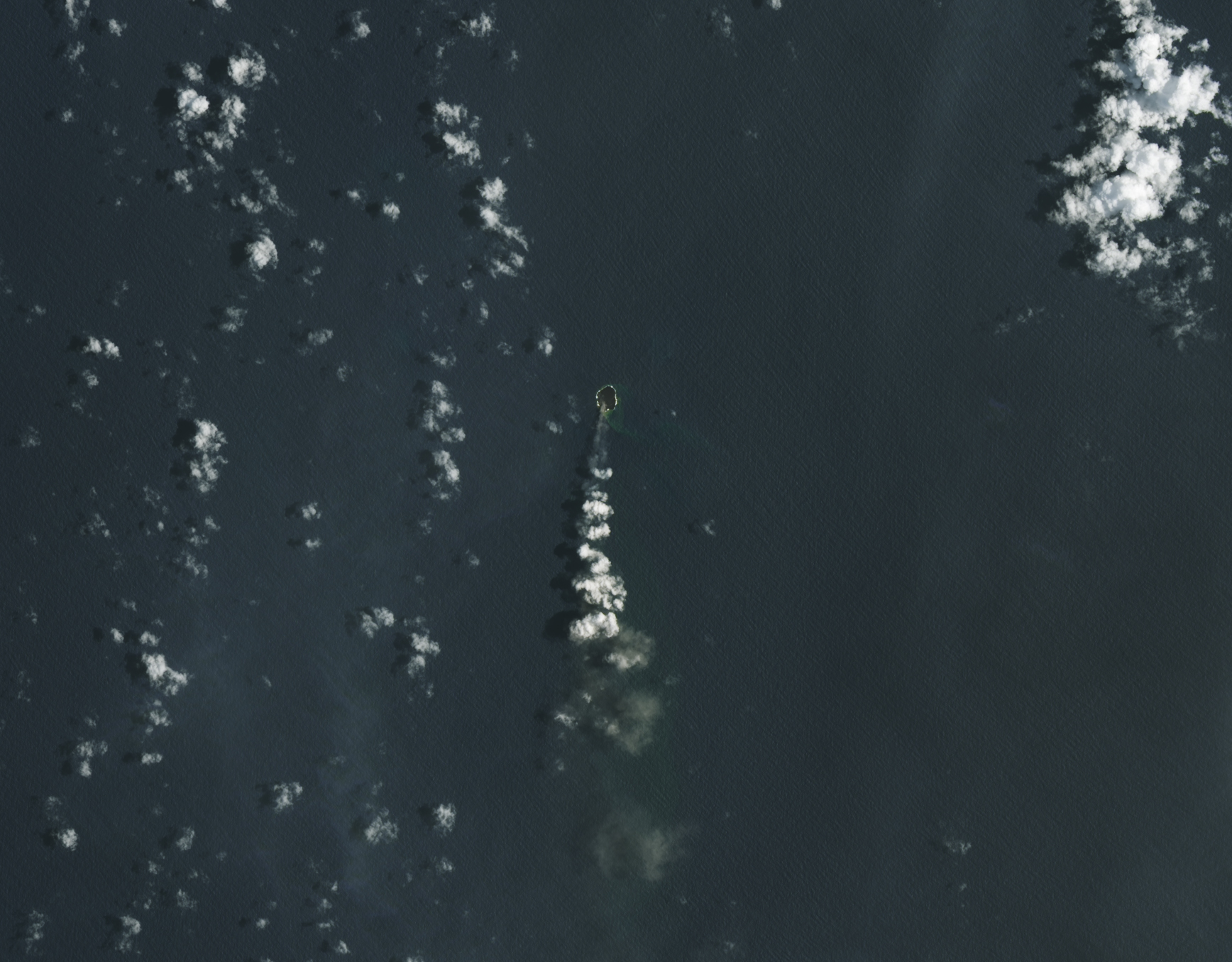
English: A small island at Tonga’s Home Reef got a little roomier in recent weeks.
The underwater volcano emerged above sea level during a 2022 eruption, adding new land to the nation of islands in the South Pacific Ocean. It continued to grow during eruptions in September 2023, January 2024, and June 2024, expanding to 12.2 hectares (30.1 acres). During the most recent period of activity, from December 2024 to January 2025, the island grew another 3.7 hectares. Landsat satellites observed the island’s recent growth spurt. The OLI-2 (Operational Land Imager-2) on Landsat 9 captured an image of the island on November 11, 2024 (left), before the latest expansion. The OLI (Operational Land Imager) on Landsat 8 imaged the same location on February 2, 2025 (right). The new land formed as lava flowed from the volcano’s vent and solidified into rock. The discolored water around the island is a sign of gases and magmatic fluids escaping from the volcano. “Most likely, we’re seeing a large amount of yellow sulfur mixing with the blue ocean to give the plumes a greenish hue,” said Cornel de Ronde, a geologist at GNS Science and the co-author of a study in Geochemistry, Geophysics, Geosystems about monitoring submarine volcanoes. The impact of underwater volcanic eruptions on marine ecosystems can be mixed. Some of the substances found in underwater plumes, especially iron, can encourage the growth of phytoplankton, said Sharon Walker, a NOAA oceanographer and lead author of the study. However, the hot, acidic plumes are also known to be harmful to many species of fish and other types of marine life. Meanwhile, the new land offers more habitat for pioneer species, such as bacteria, algae, lichens, insects, and seabirds. Prior to 2022, Home Reef had four recorded eruptions, including events in 1852 and 1857 that formed small, temporary islands. In 2006, an eruption also produced an island that had cliffs measuring up to 70 meters (230 feet) tall and survived for about nine months. Geologists expect the current island to last longer. “Some of the previous eruptions had a more explosive character, which led to land made of a more fragmented, easily erodible material,” said Simon Plank, a researcher from the German Aerospace Center (DLR). “This one is characterized by effusive flows that form a hard material that gives the island a high chance of surviving for several years.” Home Reef sits within the Tonga-Kermadec subduction zone, an area where three tectonic plates are colliding at the fastest converging boundary in the world. Here, the Pacific Plate is sinking beneath two other small plates, yielding one of Earth’s deepest trenches and most active volcanic arcs. So far, Home Reef’s eruptions have had little impact on people, unlike the neighboring Hunga Tonga-Hunga Ha‘apai volcano, which erupted in 2022, triggering a tsunami, covering nearby islands with ash, and damaging crops and fisheries. “Given what the world witnessed at Hunga, it’s certainly worth monitoring submarine volcanoes,” said de Ronde. “Satellites offer one of the best, quickest, and safest ways to do that.” NASA Earth Observatory images by Lauren Dauphin, using Landsat data from the U.S. Geological Survey. Story by Adam Voiland. |
||
| Tarix | Taken on 2 fevral 2025 | ||
| Mənbə |
A Growth Spurt for Home Reef (direct link)
|
||
| Müəllif | NASA Earth Observatory images by Lauren Dauphin, using Landsat data from the U.S. Geological Survey. Story by Adam Voiland. | ||
| Digər versiyalar |
|
||
| Keywords | Water; Image of the Day; Volcanoes; Land |
.jpg)
.jpg)
.jpg)
Lisenziya
| This file is in the public domain in the United States because it was solely created by NASA. NASA copyright policy states that "NASA material is not protected by copyright unless noted". (See Template:PD-USGov, NASA copyright policy page or JPL Image Use Policy.) | ||
Warnings:
|
This image is in the public domain in the United States because it only contains materials that originally came from the United States Geological Survey, an agency of the United States Department of the Interior. For more information, see the official USGS copyright policy.
|
Faylın tarixçəsi
Faylın əvvəlki versiyasını görmək üçün gün/tarix bölməsindəki tarixlərə klikləyin.
| Tarix/Vaxt | Miniatür | Ölçülər | İstifadəçi | Şərh | |
|---|---|---|---|---|---|
| hal-hazırkı | 22:35, 25 oktyabr 2025 | | 1.736 × 1.355 (1,05 MB) | OptimusPrimeBot | #Spacemedia - Upload of https://eoimages.gsfc.nasa.gov/images/imagerecords/153000/153941/homereef_oli_20250202_lrg.jpg via Commons:Spacemedia |
Faylın istifadəsi
Bu faylı istifadə edən səhifə yoxdur (digər layihələrdəki səhifələr göstərilmir).
.jpg)