Butun axtardiqlarinizi tapmaq ucun buraya: DAXIL OLUN
  Mp4 Mp3 Axtar Yukle
  Video Axtar Yukle
  Shekil Axtar Yukle
  Informasiya Melumat Axtar
  Hazir Inshalar Toplusu
  AZERI CHAT + Tanishliq
  1-11 Sinif Derslikler Yukle
  Saglamliq Tibbi Melumat
  Whatsapp Plus Yukle(Yeni)

  • Ana səhifə
  • Təsadüfi
  • Yaxınlıqdakılar
  • Daxil ol
  • Nizamlamalar
İndi ianə et Əgər Vikipediya sizin üçün faydalıdırsa, bu gün ianə edin.

Fayl:1945-05-01GerWW2BattlefrontAtlas.jpg

  • Fayl
  • Müzakirə
  • Lokal izah əlavə et
  • Fayl
  • Faylın tarixçəsi
  • Faylın istifadəsi
  • Faylın qlobal istifadəsi
  • Metaməlumatlar
Fayl:1945-05-01GerWW2BattlefrontAtlas.jpg
Sınaq göstərişi ölçüsü: 614 × 600 piksel. Digər ölçülər: 246 × 240 piksel | 491 × 480 piksel | 786 × 768 piksel | 1.244 × 1.215 piksel.

Faylın orijinalı (1.244 × 1.215 piksel, fayl həcmi: 1,87 MB, MIME növü: image/jpeg)

Bu fayl Vikianbarda yerləşir. Açıqlama səhifəsindəki məlumatlar aşağıda göstərilib.
Vikianbar azad lisenziyalı media anbarıdır. Siz də töhfə verə bilərsiniz.

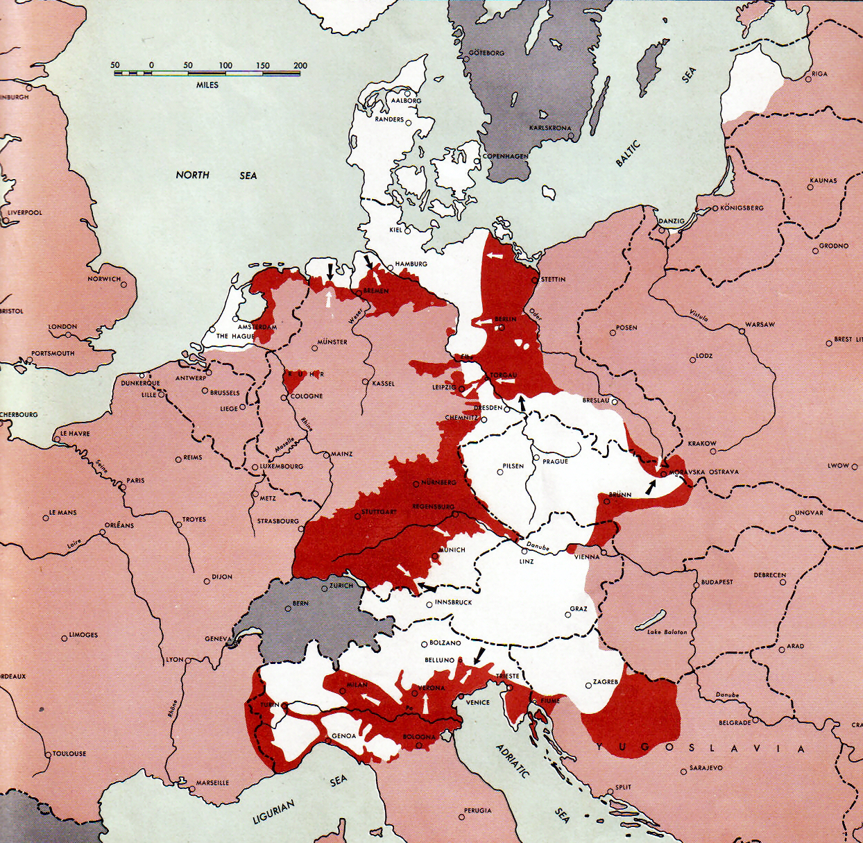
Atlas of the World Battle Fronts - War against Germany: 1945-05-01
← Previous map: 1945-04-15
→ Next map: 1945-05-15

Xülasə

İzah1945-05-01GerWW2BattlefrontAtlas.jpg
 
Neutral nations (Sweden, Switzerland, Spain, etc.)
 
Under Allied control
 
Allied forces
 
Axis forces
Map of the front against Germany: This map is taken from the source "Atlas of the World Battle Fronts in Semimonthly Phases to August 15th 1945: Supplement to The Biennial report of The Chief of Staff of the United States Army

July 1, 1943 to June 30 1945 To the Secretary of War". (See Cover, Forward and Map details)

Tarix 1945
Mənbə Document "Atlas of the World Battle Fronts in Semimonthly Phases to August 15th 1945: Supplement to The Biennial report of the Chief of Staff of the United States Army July 1, 1943 to June 30 1945 To the Secretary of War"
Müəllif Army Map Service
İcazə
(Faylın təkrar istifadəsi)
Public Domain: Work of US army

Lisenziya

Public domainPublic domainfalsefalse
Public domain
This file is a work of a U.S. Army soldier or employee, taken or made as part of that person's official duties. As a work of the U.S. federal government, it is in the public domain in the United States.

العربية ∙ বাংলা ∙ català ∙ čeština ∙ Deutsch ∙ English ∙ español ∙ eesti ∙ فارسی ∙ suomi ∙ français ∙ hrvatski ∙ magyar ∙ Bahasa Indonesia ∙ italiano ∙ 日本語 ∙ 한국어 ∙ lietuvių ∙ македонски ∙ മലയാളം ∙ မြန်မာဘာသာ ∙ Nederlands ∙ polski ∙ português ∙ русский ∙ sicilianu ∙ српски / srpski ∙ svenska ∙ Türkçe ∙ українська ∙ Tiếng Việt ∙ 中文 ∙ 中文(简体) ∙ 中文(繁體) ∙ 中文(臺灣) ∙ +/−

Başlıqlar

Bu faylın nəyi təmsil etdiyinə dair bir sətirlik izahat əlavə et
WWII front lines on 1 May 1945. Pink = Allied-occupied territory; red = area of fighting.

Bu faylda təsvir olunan elementlər

təsvir edir

May 1945 ingilis

Avropada İkinci dünya müharibəsinin sonu

Courland Pocket ingilis

copyright status ingilis

ictimai varidat

yurisdiksiyasındadır: Amerika Birləşmiş Ştatları
təyinetmə üsulu: work of the federal government of the United States ingilis

yaranma tarixi

1945

media type ingilis

image/jpeg

checksum ingilis

41b6b3471e55b7b58cff66656cd189c75139c6e3

təyinetmə üsulu: SHA-1

data size ingilis

1.962.322 Bayt

hündürlüyü/boyu

1.215 piksel

eni

1.244 piksel

Faylın tarixçəsi

Faylın əvvəlki versiyasını görmək üçün gün/tarix bölməsindəki tarixlərə klikləyin.

Tarix/VaxtMiniatürÖlçülərİstifadəçiŞərh
hal-hazırkı13:53, 10 sentyabr 201113:53, 10 sentyabr 2011 tarixindəki versiyanın miniatür görüntüsü1.244 × 1.215 (1,87 MB)FinavonReverted to version as of 15:34, 6 November 2010 COM:USOP and en:MOS:IMAGES
03:15, 10 sentyabr 201103:15, 10 sentyabr 2011 tarixindəki versiyanın miniatür görüntüsü1.274 × 1.715 (1,82 MB)Whoop whoop pull upReverted to version as of 23:50, 2 April 2011: Rv unexplained and unneeded crop.
11:30, 2 iyun 201111:30, 2 iyun 2011 tarixindəki versiyanın miniatür görüntüsü1.244 × 1.215 (1,87 MB)DIREKTOR
23:50, 2 aprel 201123:50, 2 aprel 2011 tarixindəki versiyanın miniatür görüntüsü1.274 × 1.715 (1,82 MB)Whoop whoop pull upReverted to version as of 20:15, 24 December 2007 The caption is very useful and practically all the other pictures in this series have retained them.
15:34, 6 noyabr 201015:34, 6 noyabr 2010 tarixindəki versiyanın miniatür görüntüsü1.244 × 1.215 (1,87 MB)DIREKTORCrop
20:15, 24 dekabr 200720:15, 24 dekabr 2007 tarixindəki versiyanın miniatür görüntüsü1.274 × 1.715 (1,82 MB)Mike Young{{Information |Description= thumb|left|75pxthumb|right|75pxMap of the front against Germany: This map is taken from the source "Atlas of the World Battle Fronts in Semimonthly

Faylın istifadəsi

Aşağıdakı səhifə bu faylı istifadə edir:

  • Nasist Almaniyasının ərazi-siyasi ekspansiyası

Faylın qlobal istifadəsi

Bu fayl aşağıdakı vikilərdə istifadə olunur:

  • ar.wikipedia.org layihəsində istifadəsi
    • معركة برلين
    • المسرح الأوروبي للحرب العالمية الثانية
    • المعركة في برلين
  • be.wikipedia.org layihəsində istifadəsi
    • Італьянская кампанія (1943—1945)
  • bg.wikipedia.org layihəsində istifadəsi
    • Битка за Берлин
    • Смърт на Адолф Хитлер
    • Италианска кампания (Втора световна война)
  • bs.wikipedia.org layihəsində istifadəsi
    • Masakr u Bleiburgu
  • ca.wikipedia.org layihəsində istifadəsi
    • Batalla de Berlín
  • cs.wikipedia.org layihəsində istifadəsi
    • Pražské povstání
    • Pražská ofenzíva
    • Bitva o Berlín
  • da.wikipedia.org layihəsində istifadəsi
    • Felttoget i Italien
    • Atlas of the World Battle Fronts
  • de.wikipedia.org layihəsində istifadəsi
    • Zweiter Weltkrieg
    • Bedingungslose Kapitulation der Wehrmacht
    • Militärische Operationen im Zweiten Weltkrieg
    • Chronologie des Zweiten Weltkrieges
    • Benutzer:Soenke Rahn/Kriegsende in Schleswig-Holstein (1945)
  • el.wikipedia.org layihəsində istifadəsi
    • Β΄ Παγκόσμιος Πόλεμος στη Γιουγκοσλαβία
    • Θάνατος του Αδόλφου Χίτλερ
  • en.wikipedia.org layihəsində istifadəsi
    • Battle of Berlin
    • Italian campaign (World War II)
    • Bleiburg repatriations
    • Death of Adolf Hitler
    • Flensburg Government
    • Courland Pocket
    • World War II in Yugoslavia
    • Timeline of World War II (1945)
    • User:Eurocopter/Sandbox/Archive 1
    • Wikipedia talk:Requests for mediation/Draza Mihailovic/Archive20
    • Wikipedia:Reference desk/Archives/Humanities/2012 November 10
    • User:Chickstarr404/Gather lists/12545 – "Exorcising Hitler"
  • en.wikisource.org layihəsində istifadəsi
    • Atlas of the World Battle Fronts in Semimonthly Phases to August 15 1945
  • eo.wikipedia.org layihəsində istifadəsi
    • Kurlanda Sako
  • es.wikipedia.org layihəsində istifadəsi
    • Muerte de Adolf Hitler
    • Gobierno de Flensburgo
  • et.wikipedia.org layihəsində istifadəsi
    • Teine maailmasõda
  • fa.wikipedia.org layihəsində istifadəsi
    • مرگ آدولف هیتلر
    • دولت فلنسبورگ
  • fi.wikipedia.org layihəsində istifadəsi
    • Prahan kansannousu 1945
  • fr.wikipedia.org layihəsində istifadəsi
    • Bataille de Berlin
    • Gouvernement de Flensbourg
    • Poche de Courlande
    • Théâtre européen de la Seconde Guerre mondiale
    • Vague de suicides de Demmin
  • he.wikipedia.org layihəsində istifadəsi
    • כיס קורלנד
  • hr.wikipedia.org layihəsində istifadəsi
    • Bleiburška tragedija
    • Drugi svjetski rat u Bosni i Hercegovini
  • hy.wikipedia.org layihəsində istifadəsi
    • Ադոլֆ Հիտլերի մահ

Bu faylın qlobal istifadəsinə baxın.

Metaməlumatlar

Bu faylda fotoaparat və ya skanerlə əlavə olunmuş məlumatlar var. Əgər fayl sonradan olunubsa, bəzi parametrlər bu şəkildə göstərilənlərdən fərqli ola bilər.

OrientasiyaNormal
Üfüqi xətt150 dpi
Şaquli xətt150 dpi
Proqram təminatıAdobe Photoshop CS5 Windows
Faylın dəyişməsi tarixi və vaxtı16:32, 6 noyabr 2010
Rəng sahəsisRGB
Tarix və vaxt rəqəmləşdirilir17:32, 6 noyabr 2010
Date metadata was last modified17:32, 6 noyabr 2010
Unique ID of original documentxmp.did:3B567614BBE9DF1181F0C79D050F21C7
Mənbə — "https://az.wikipedia.org/wiki/Fayl:1945-05-01GerWW2BattlefrontAtlas.jpg"
Informasiya Melumat Axtar