Butun axtardiqlarinizi tapmaq ucun buraya: DAXIL OLUN
  Mp4 Mp3 Axtar Yukle
  Video Axtar Yukle
  Shekil Axtar Yukle
  Informasiya Melumat Axtar
  Hazir Inshalar Toplusu
  AZERI CHAT + Tanishliq
  1-11 Sinif Derslikler Yukle
  Saglamliq Tibbi Melumat
  Whatsapp Plus Yukle(Yeni)

  • Ana səhifə
  • Təsadüfi
  • Yaxınlıqdakılar
  • Daxil ol
  • Nizamlamalar
İndi ianə et Əgər Vikipediya sizin üçün faydalıdırsa, bu gün ianə edin.

Fayl:1944-12-15GerWW2BattlefrontAtlas.jpg

  • Fayl
  • Müzakirə
  • Lokal izah əlavə et
  • Fayl
  • Faylın tarixçəsi
  • Faylın istifadəsi
  • Faylın qlobal istifadəsi
  • Metaməlumatlar
Fayl:1944-12-15GerWW2BattlefrontAtlas.jpg
Sınaq göstərişi ölçüsü: 621 × 599 piksel. Digər ölçülər: 249 × 240 piksel | 497 × 480 piksel | 796 × 768 piksel | 1.254 × 1.210 piksel.

Faylın orijinalı (1.254 × 1.210 piksel, fayl həcmi: 633 KB, MIME növü: image/jpeg)

Bu fayl Vikianbarda yerləşir. Açıqlama səhifəsindəki məlumatlar aşağıda göstərilib.
Vikianbar azad lisenziyalı media anbarıdır. Siz də töhfə verə bilərsiniz.

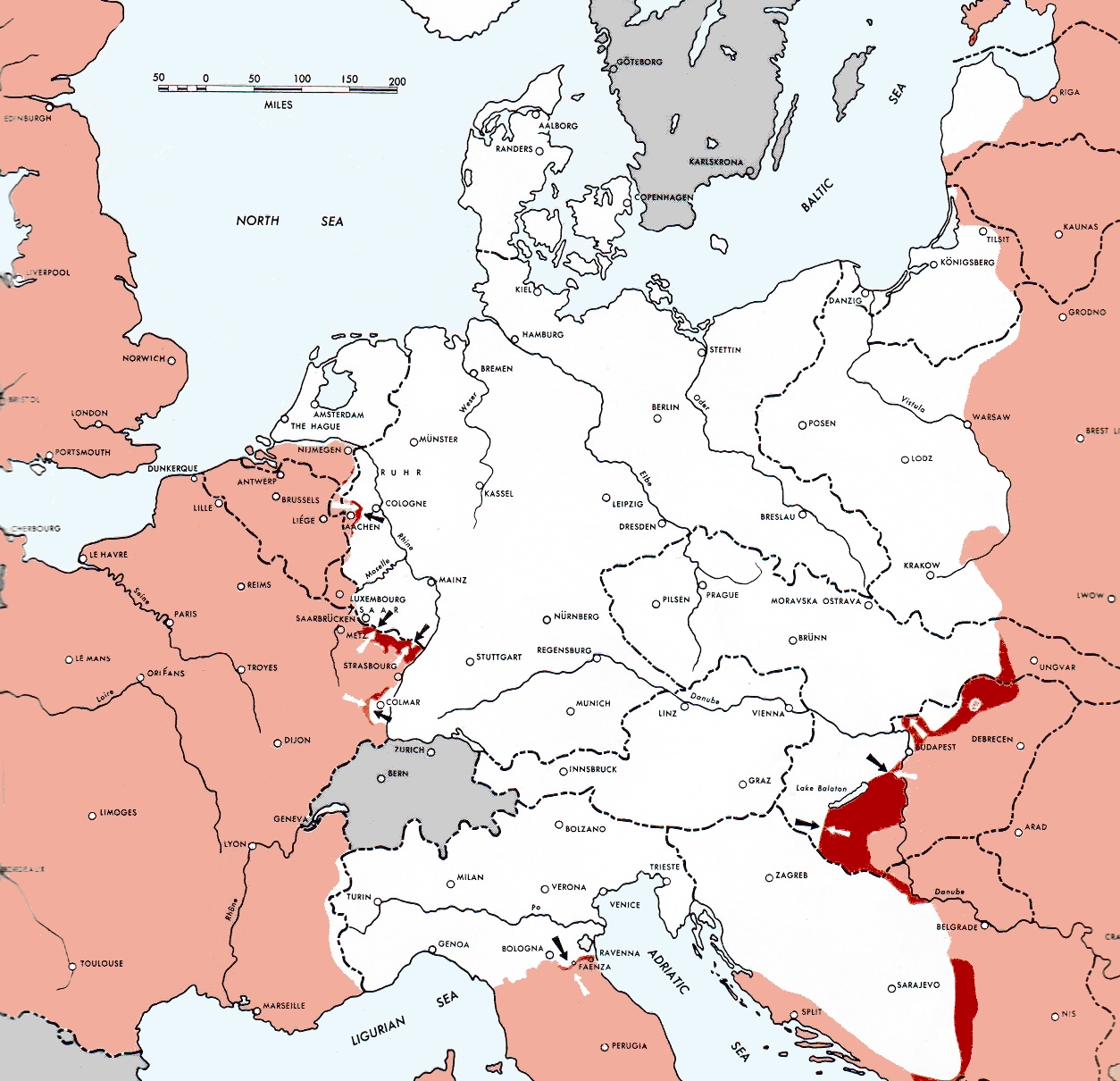
Atlas of the World Battle Fronts - War against Germany: 1944-12-15
← Previous map: 1944-12-01
→ Next map: 1945-01-01

Xülasə

İzah1944-12-15GerWW2BattlefrontAtlas.jpg
Map of the front against Germany: This map is taken from the source "Atlas of the World Battle Fronts in Semimonthly Phases to August 15th 1945: Supplement to The Biennial report of The Chief of Staff of the United States Army

July 1, 1943 to June 30 1945 To the Secretary of War". (See Cover, Forward and Map details)

Tarix 1945
Mənbə Document "Atlas of the World Battle Fronts in Semimonthly Phases to August 15th 1945: Supplement to The Biennial report of the Chief of Staff of the United States Army July 1, 1943 to June 30 1945 To the Secretary of War"
Müəllif Army Map Service
İcazə
(Faylın təkrar istifadəsi)
Public Domain: Work of US army

Lisenziya

Public domainPublic domainfalsefalse
Public domain
This file is a work of a U.S. Army soldier or employee, taken or made as part of that person's official duties. As a work of the U.S. federal government, it is in the public domain in the United States.

العربية ∙ বাংলা ∙ català ∙ čeština ∙ Deutsch ∙ English ∙ español ∙ eesti ∙ فارسی ∙ suomi ∙ français ∙ hrvatski ∙ magyar ∙ Bahasa Indonesia ∙ italiano ∙ 日本語 ∙ 한국어 ∙ lietuvių ∙ македонски ∙ മലയാളം ∙ မြန်မာဘာသာ ∙ Nederlands ∙ polski ∙ português ∙ русский ∙ sicilianu ∙ српски / srpski ∙ svenska ∙ Türkçe ∙ українська ∙ Tiếng Việt ∙ 中文 ∙ 中文(简体) ∙ 中文(繁體) ∙ 中文(臺灣) ∙ +/−

Başlıqlar

Bu faylın nəyi təmsil etdiyinə dair bir sətirlik izahat əlavə et

Bu faylda təsvir olunan elementlər

təsvir edir

copyright status ingilis

ictimai mülkiyyət

yurisdiksiyasındadır: Amerika Birləşmiş Ştatları
təyinetmə üsulu: work of the federal government of the United States ingilis

yaranma tarixi

1945

media type ingilis

image/jpeg

checksum ingilis

17cb4410034dc487ad44bd6bef9fc560c6905823

təyinetmə üsulu: SHA-1

data size ingilis

648.338 Bayt

hündürlüyü/boyu

1.210 piksel

eni

1.254 piksel

Faylın tarixçəsi

Faylın əvvəlki versiyasını görmək üçün gün/tarix bölməsindəki tarixlərə klikləyin.

Tarix/VaxtMiniatürÖlçülərİstifadəçiŞərh
hal-hazırkı01:00, 23 may 202101:00, 23 may 2021 tarixindəki versiyanın miniatür görüntüsü1.254 × 1.210 (633 KB)HohumReworked from original.
08:52, 1 may 202008:52, 1 may 2020 tarixindəki versiyanın miniatür görüntüsü1.254 × 1.210 (906 KB)Wikirictorcropped, enhanced contrast and color
10:44, 28 avqust 201110:44, 28 avqust 2011 tarixindəki versiyanın miniatür görüntüsü1.254 × 1.210 (1,17 MB)Cropbotupload cropped version, operated by User:Finavon. Summary: caption cropped
19:09, 24 dekabr 200719:09, 24 dekabr 2007 tarixindəki versiyanın miniatür görüntüsü1.274 × 1.754 (1,69 MB)Mike Young{{Information |Description= thumb|left|75pxthumb|right|75pxMap of the front against Germany: This map is taken from the source "Atlas of the World Battle Fronts in Semimonthly

Faylın istifadəsi

Aşağıdakı səhifə bu faylı istifadə edir:

  • Nasist Almaniyasının ərazi-siyasi ekspansiyası

Faylın qlobal istifadəsi

Bu fayl aşağıdakı vikilərdə istifadə olunur:

  • ar.wikipedia.org layihəsində istifadəsi
    • المسرح الأوروبي للحرب العالمية الثانية
    • التسلسل الزمني للحرب العالمية الثانية (1944)
  • be.wikipedia.org layihəsində istifadəsi
    • Італьянская кампанія (1943—1945)
  • bg.wikipedia.org layihəsində istifadəsi
    • Италианска кампания (Втора световна война)
  • da.wikipedia.org layihəsində istifadəsi
    • Felttoget i Italien
    • Atlas of the World Battle Fronts
  • en.wikipedia.org layihəsində istifadəsi
    • European theatre of World War II
    • Italian campaign (World War II)
    • Two-front war
    • Timeline of World War II (1944)
    • User:Falcaorib/Europe
    • User:Falcaorib/Germany and Prussia
  • en.wikisource.org layihəsində istifadəsi
    • Atlas of the World Battle Fronts in Semimonthly Phases to August 15 1945
  • fr.wikipedia.org layihəsində istifadəsi
    • Théâtre européen de la Seconde Guerre mondiale
  • id.wikipedia.org layihəsində istifadəsi
    • Urutan waktu Perang Dunia II (1944)
  • ko.wikipedia.org layihəsində istifadəsi
    • 유럽 전구 (제2차 세계 대전)
  • lv.wikipedia.org layihəsində istifadəsi
    • Itālijas kampaņa
  • no.wikipedia.org layihəsində istifadəsi
    • Atlas of the World Battle Fronts
  • pnb.wikipedia.org layihəsində istifadəsi
    • دوسری جنگ عظیم دا یورپی تھیٹر
  • pt.wikipedia.org layihəsində istifadəsi
    • Teatro Europeu da Segunda Guerra Mundial
  • ru.wikipedia.org layihəsində istifadəsi
    • Итальянская кампания (1943—1945)
    • Территориально-политическая экспансия нацистской Германии
  • sh.wikipedia.org layihəsində istifadəsi
    • Završna četnička dejstva u Bosni (1944–1945)
  • tr.wikipedia.org layihəsində istifadəsi
    • II. Dünya Savaşı'nda Avrupa Cephesi
  • uk.wikipedia.org layihəsində istifadəsi
    • Територіально-політична експансія Третього Рейху
    • Європейський театр Другої світової війни
  • ur.wikipedia.org layihəsində istifadəsi
    • دوسری جنگ عظیم کا یورپی تھیٹر
  • vi.wikipedia.org layihəsində istifadəsi
    • Bản đồ thế giới trong Chiến tranh thế giới thứ hai
    • Chủ đề:Chiến tranh thế giới thứ hai/Bản đồ

Metaməlumatlar

Bu faylda fotoaparat və ya skanerlə əlavə olunmuş məlumatlar var. Əgər fayl sonradan olunubsa, bəzi parametrlər bu şəkildə göstərilənlərdən fərqli ola bilər.

OrientasiyaNormal
Üfüqi xətt150 dpi
Şaquli xətt150 dpi
Proqram təminatıGIMP 2.10.24
Faylın dəyişməsi tarixi və vaxtı01:59, 23 may 2021
Rəng sahəsisRGB
Unique ID of original documentxmp.did:9fbc0100-e6fb-4e41-a28c-c2de42a8ec61
Mənbə — "https://az.wikipedia.org/wiki/Fayl:1944-12-15GerWW2BattlefrontAtlas.jpg"
Informasiya Melumat Axtar