Butun axtardiqlarinizi tapmaq ucun buraya: DAXIL OLUN
  Mp4 Mp3 Axtar Yukle
  Video Axtar Yukle
  Shekil Axtar Yukle
  Informasiya Melumat Axtar
  Hazir Inshalar Toplusu
  AZERI CHAT + Tanishliq
  1-11 Sinif Derslikler Yukle
  Saglamliq Tibbi Melumat
  Whatsapp Plus Yukle(Yeni)

  • Ana səhifə
  • Təsadüfi
  • Yaxınlıqdakılar
  • Daxil ol
  • Nizamlamalar
İndi ianə et Əgər Vikipediya sizin üçün faydalıdırsa, bu gün ianə edin.

Fayl:Nile River and delta from orbit.jpg

  • Fayl
  • Müzakirə
  • Vikianbar üzərindən baxış
  • Lokal izah əlavə et
  • Fayl
  • Faylın tarixçəsi
  • Faylın istifadəsi
  • Faylın qlobal istifadəsi
Fayl:Nile River and delta from orbit.jpg
Daha yüksək versiyası yoxdur.
Nile_River_and_delta_from_orbit.jpg (700 × 550 piksel, fayl həcmi: 85 KB, MIME növü: image/jpeg)
Bu fayl Vikianbarda yerləşir. Açıqlama səhifəsindəki məlumatlar aşağıda göstərilib.
Vikianbar azad lisenziyalı media anbarıdır. Siz də töhfə verə bilərsiniz.

Xülasə

İzahNile River and delta from orbit.jpg

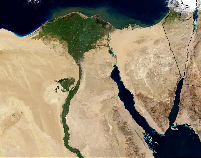
Nile River and delta from orbit Description: The Nile River and delta as seen from space by the MODIS sensor on the Terra satellite.

"Against the barren desert of northeastern Africa, the fertile valley of the Nile River runs northward through Egypt. In the higher-resolution images, the city of Cairo can be seen as a gray smudge right where the river widens into its broad fan-shaped delta. Other cities are dotted across the green landscape, giving it a speckled appearance. Where the Nile empties into the Mediterranean Sea (top) the waters are swirling with color, likely a mixture of sediment, organic matter, and possibly marine plant life. Farther west, the bright blue color of the water is likely less-organically rich sediment, perhaps sand.
"East of the delta lies the arid Sinai Peninsula, whose pointed tip is home to rugged mountains, some as high as 8,600 feet. The lattice work of pale lines marks the paths of ephemeral rivers. The Sinai Peninsula intrudes into the Red Sea. Farther east are Israel, Jordan, and Saudi Arabia. At top right is the disputed territory of the West Bank.
"In the false-color image, vegetation is bright green, water is dark blue or black, and clouds are light blue. It's interesting to notice that places that seem essentially arid, or desert-like in the true-color image in fact have a delicate layer of vegetation. For example, the central Sinai Peninsula, and most of Israel have a faint greenish tinge in the false-color images.
Українська: Супутниковий знімок дельти Нілу і Синайського півострова, Єгипет, 5 лютого 2003 року.
Tarix 5 fevral 2003
Mənbə http://visibleearth.nasa.gov/view_rec.php?id=4927 [1]
Müəllif Jacques Descloitres, MODIS Rapid Response Team, NASA/sh
Digər versiyalar
Cuaggjacgacugvajgca

Salchicha

Lisenziya

Public domainPublic domainfalsefalse
Public domain This file is in the public domain in the United States because it was solely created by NASA. NASA copyright policy states that "NASA material is not protected by copyright unless noted". (See Template:PD-USGov, NASA copyright policy page or JPL Image Use Policy.)
Warnings:
  • Use of NASA logos, insignia and emblems is restricted per U.S. law 14 CFR 1221.
  • The NASA website hosts a large number of images from the Soviet/Russian space agency, and other non-American space agencies. These are not necessarily in the public domain.
  • Materials based on Hubble Space Telescope data may be copyrighted if they are not explicitly produced by the STScI.[2] See also {{PD-Hubble}} and {{Cc-Hubble}}.
  • The SOHO (ESA & NASA) joint project implies that all materials created by its probe are copyrighted and require permission for commercial non-educational use. [3]
  • Images featured on the Astronomy Picture of the Day (APOD) web site may be copyrighted. [4]
  • The National Space Science Data Center (NSSDC) site has been known to host copyrighted content. Its photo gallery FAQ states that all of the images in the photo gallery are in the public domain "Unless otherwise noted."

Başlıqlar

Bu faylın nəyi təmsil etdiyinə dair bir sətirlik izahat əlavə et
Nile delta
delta del río Nilo
Nildelta

Bu faylda təsvir olunan elementlər

təsvir edir

copyright status ingilis

ictimai mülkiyyət

yurisdiksiyasındadır: Amerika Birləşmiş Ştatları
təyinetmə üsulu: work of the federal government of the United States ingilis

yaranma tarixi

5 fevral 2003

media type ingilis

image/jpeg

data size ingilis

86.876 Bayt

hündürlüyü/boyu

550 piksel

eni

700 piksel

checksum ingilis

770cb4720dbd887a6e7888a523804efc446bafd8

təyinetmə üsulu: SHA-1

Faylın tarixçəsi

Faylın əvvəlki versiyasını görmək üçün gün/tarix bölməsindəki tarixlərə klikləyin.

Tarix/VaxtMiniatürÖlçülərİstifadəçiŞərh
hal-hazırkı22:47, 29 noyabr 200422:47, 29 noyabr 2004 tarixindəki versiyanın miniatür görüntüsü700 × 550 (85 KB)MschlindweinNile River and delta from orbit

Faylın istifadəsi

Bu faylı istifadə edən səhifə yoxdur.

Faylın qlobal istifadəsi

Bu fayl aşağıdakı vikilərdə istifadə olunur:

  • ady.wikipedia.org layihəsində istifadəsi
    • Нил (псыхъо)
  • af.wikipedia.org layihəsində istifadəsi
    • Wikipedia:Voorbladartikels 2006
    • Nyldelta
    • Wikipedia:Voorbladartikel week 11 2006
    • Nylrivier
    • Landengte van Suez
  • ar.wikipedia.org layihəsində istifadəsi
    • الوطن العربي
    • دلتا النيل
    • تيران (جزيرة)
    • تحلل بيئي
    • مستخدم:Insan1411
    • بوابة:جغرافيا/صورة مختارة/أرشيف
    • بوابة:جغرافيا/صورة مختارة/11
    • تدهور بيئي
    • قضية تيران وصنافير
    • مخطط مصر
    • برزخ السويس
  • arz.wikipedia.org layihəsində istifadəsi
    • دلتا النيل
  • ast.wikipedia.org layihəsində istifadəsi
    • Historia d'Exiptu
  • av.wikipedia.org layihəsində istifadəsi
    • Синаялъул бащдаб чӀинкӀиллъи
    • Нилалъул делта
  • azb.wikipedia.org layihəsində istifadəsi
    • نیل چایی
  • be-tarask.wikipedia.org layihəsində istifadəsi
    • Сынайскі паўвостраў
  • be.wikipedia.org layihəsində istifadəsi
    • Ніл
    • Сінайскі паўвостраў
    • Суэцкі перашыек
  • bg.wikipedia.org layihəsində istifadəsi
    • География на Египет
    • Нил
    • Делта (география)
    • Делта на Нил
    • Суецки провлак
  • bn.wikipedia.org layihəsində istifadəsi
    • নীলনদ
  • bn.wikibooks.org layihəsində istifadəsi
    • উইকিশৈশব:ছবিতে বিশ্বের ইতিহাস/প্রাচীন মিশরীয়
  • bxr.wikipedia.org layihəsində istifadəsi
    • Гол мүрэн
  • ca.wikipedia.org layihəsində istifadəsi
    • Accident geogràfic
    • Nil
    • Història d'Egipte
    • Delta del Nil
    • Istme de Suez
  • ceb.wikipedia.org layihəsində istifadəsi
    • Isthmus of Suez
    • Nile Delta
  • cs.wikipedia.org layihəsində istifadəsi
    • Delta Nilu
    • Suezská šíje
  • cv.wikipedia.org layihəsində istifadəsi
    • Нил
    • Синай çурутравĕ
  • cy.wikipedia.org layihəsində istifadəsi
    • Hawl dynol i ddŵr a glanweithdra
  • da.wikipedia.org layihəsində istifadəsi
    • Nildeltaet
  • de.wikipedia.org layihəsində istifadəsi
    • Nildelta
    • Liste griechischer Phrasen/Delta
    • Wikipedia Diskussion:Hauptseite/Artikel des Tages/Archiv/Vorschläge/2021/Q4

Bu faylın qlobal istifadəsinə baxın.

Mənbə — "https://az.wikipedia.org/wiki/Fayl:Nile_River_and_delta_from_orbit.jpg"
Informasiya Melumat Axtar